ATTENTION: To use this site, it is necessary to enable JavaScript in your browser.
Here are the Instructions on how to enable JavaScript in your web browser.

🌿 How Energy, Water & Motion Shape the Sky

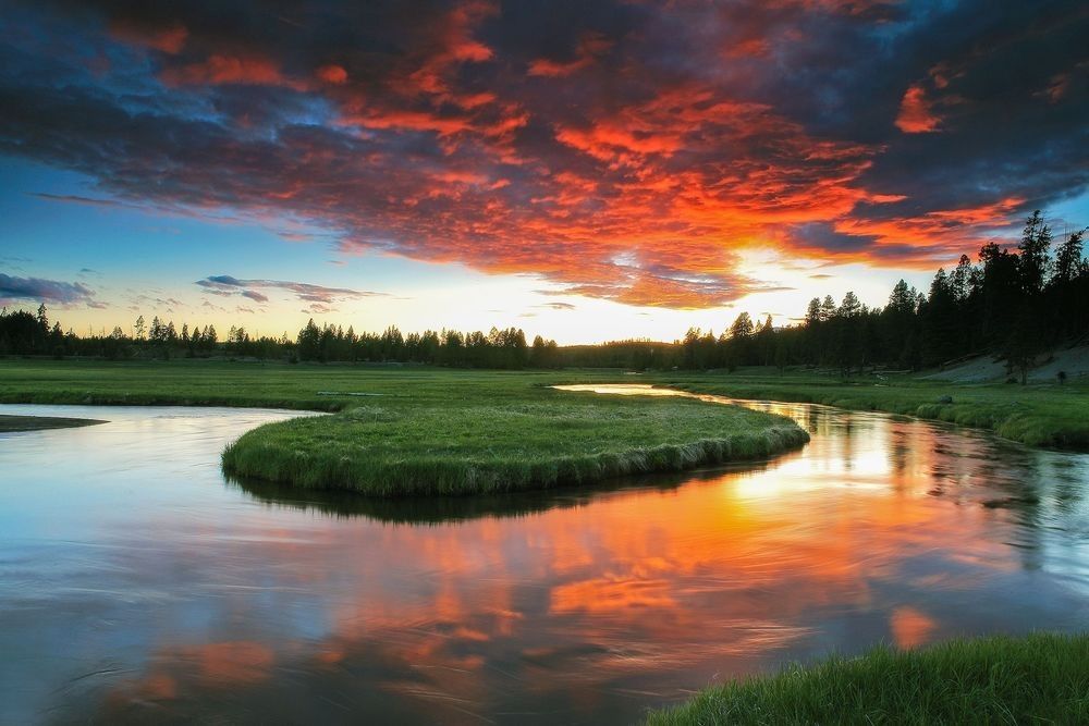
Brilliant red and orange clouds reflecting across a winding Yellowstone river and meadow, illustrating how sunlight, water, clouds, energy, and atmospheric motion shape weather across the landscape.

Naturepedia™

Weather™

How Energy, Water & Motion Shape the Sky

Weather™ explores how sunlight, temperature, water vapor, air pressure, wind, clouds, and landscapes interact to create the changing conditions experienced across Earth. From quiet fog, passing rain, and shifting cloud layers to jet streams and organized storms, weather reveals the atmosphere as a dynamic system connecting water, land, ecosystems, wildlife, and life.

Hero Photograph: Yellowstone — Fine art nature photography by Robbie George illustrating how sunlight, clouds, water, atmospheric color, and a living landscape come together within one changing weather system.

What Creates Weather Across Earth?

Weather begins with energy. Sunlight warms Earth unevenly because oceans, forests, mountains, deserts, snowfields, wetlands, and cities absorb and release heat differently. These temperature differences create changes in air pressure. Air begins to move, moisture rises from oceans and landscapes, clouds form, and precipitation returns water to the surface. What appears overhead as sunshine, fog, wind, rain, snow, or a thunderstorm is the visible result of these connected exchanges.

Earth’s rotation, global circulation, pressure gradients, topography, and the distribution of land and water continually redirect that energy and moisture. The jet stream guides many storm tracks. Mountains force air upward and can produce clouds, rain, and snow. Oceans supply enormous quantities of atmospheric moisture, while forests, soils, wetlands, lakes, and plants return water to the atmosphere through evaporation and transpiration. Weather therefore emerges through relationships rather than through any single atmospheric force.

Weather and climate are closely connected but are not the same. Weather describes atmospheric conditions unfolding over shorter periods, while climate describes the longer-term patterns, ranges, and tendencies observed across seasons, decades, and regions. Within Naturepedia™, Weather™ provides the immediate atmospheric layer connecting Earth Systems™, Water Systems™, Carbon Cycle™, and Climate Carbon Feedbacks™.

Weather also shapes living systems. Rainfall supports forests, wetlands, rivers, soils, and agriculture. Temperature and snowpack influence plant growth, migration, breeding, feeding, and seasonal wildlife movement. Storms redistribute water, nutrients, sediment, and biological material across landscapes. These relationships connect Weather™ with Ecosystem Feedbacks™, Quantum Agriculture™, Wildlife Migration & Seasonal Patterns, and Naturepedia’s expanding network of Field Locations.

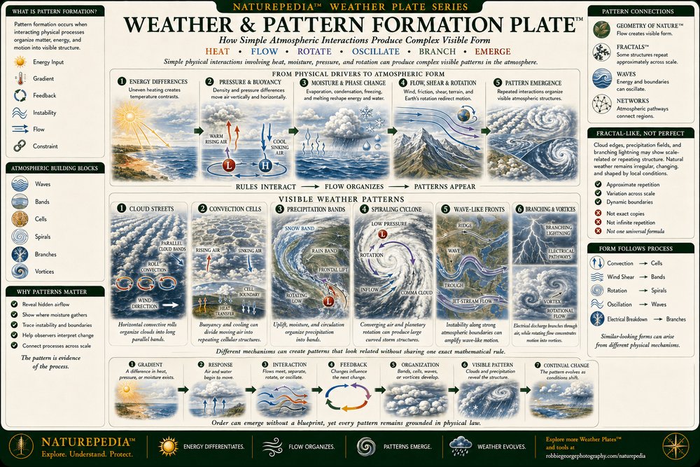
Weather™ also contains visible forms of natural pattern formation. Cloud streets, convection cells, spiraling storms, wave-like fronts, branching lightning, and repeating precipitation bands reveal how local physical interactions can create larger atmospheric organization. These structures connect Weather™ with Geometry of Nature™ and Fractals™, while remaining grounded in the flexible, changing behavior of real atmospheric systems rather than perfect mathematical forms.


Explore Weather™

Naturepedia™ Weather Plate

Weather Plate™

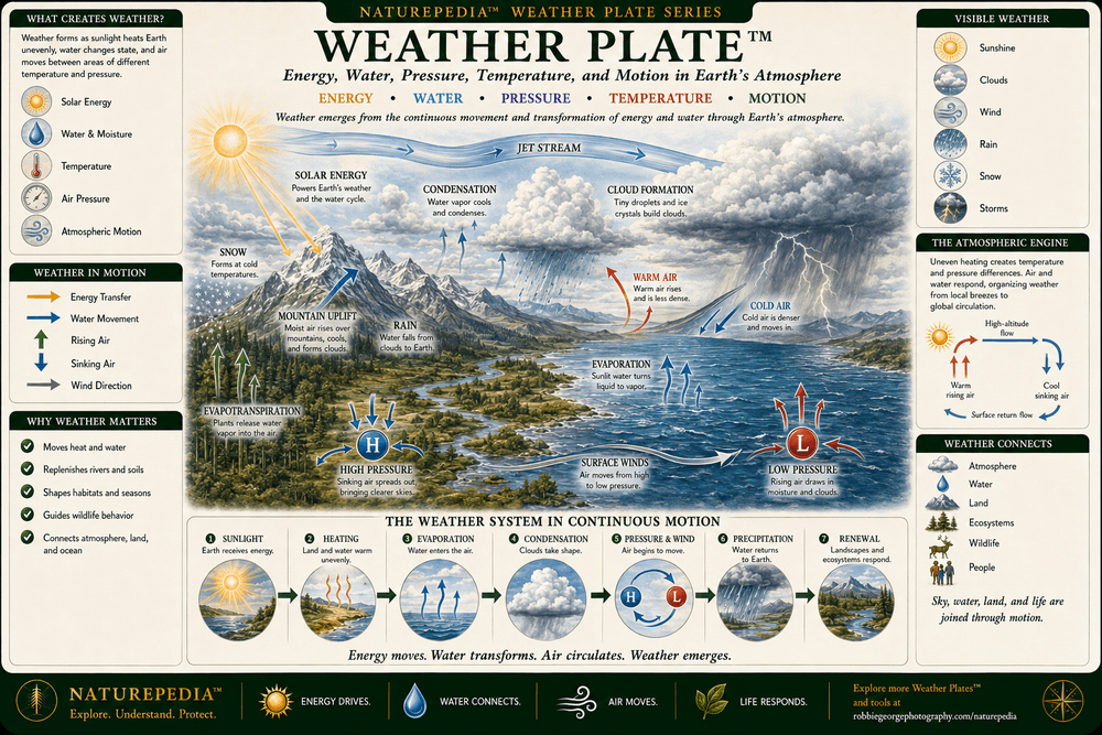
Weather™ introduces the atmosphere as a continuously moving Earth system shaped by solar energy, water, temperature, pressure, and motion. Sunlight warms land and water unevenly, moisture rises and condenses, clouds develop, winds redistribute energy, and precipitation returns water to the landscape—connecting the atmosphere, oceans, mountains, ecosystems, wildlife, and people.

Weather Plate showing solar energy, a jet stream, clouds, mountain uplift, condensation, rain, snow, evaporation, evapotranspiration, surface winds, warm and cold air, and high- and low-pressure systems working together across Earth's atmosphere.
Weather Plate™ — a Naturepedia™ master overview showing how solar energy, water, clouds, temperature, air pressure, wind, precipitation, and atmospheric circulation work together to create weather across Earth.

Visible Plate ID: weather#weather-plate

Type: Naturepedia Weather Master Plate™

Naturepedia™ Water Cycle Plate

Water Cycle Plate™

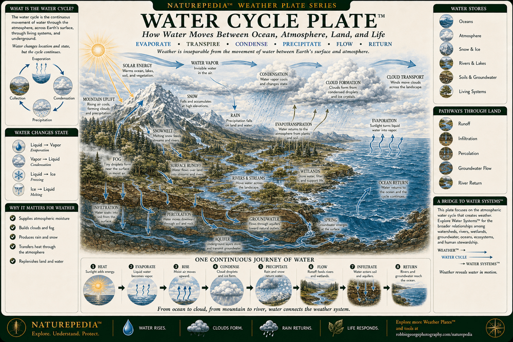
The Water Cycle™ follows water as it moves continuously between oceans, atmosphere, mountains, rivers, groundwater, soils, plants, and living ecosystems. Solar energy drives evaporation, water vapor rises and condenses into clouds, precipitation returns moisture to the surface, and rivers and groundwater carry it back toward the ocean—creating one continuous journey connecting weather with Earth’s wider water systems.

Water Cycle Plate showing solar energy, ocean evaporation, water vapor, condensation, cloud formation, cloud transport, rain, snow, mountain uplift, snowmelt, surface runoff, rivers, wetlands, infiltration, groundwater, springs, evapotranspiration, and water returning to the ocean.
Water Cycle Plate™ — a Naturepedia™ overview showing how water evaporates, forms clouds, returns as rain and snow, moves across and beneath the landscape, supports living systems, and eventually flows back to the ocean.

Visible Plate ID: weather#water-cycle-plate

Type: Naturepedia Water Cycle Plate™

Naturepedia™ Atmospheric Circulation Plate

Atmospheric Circulation Plate™

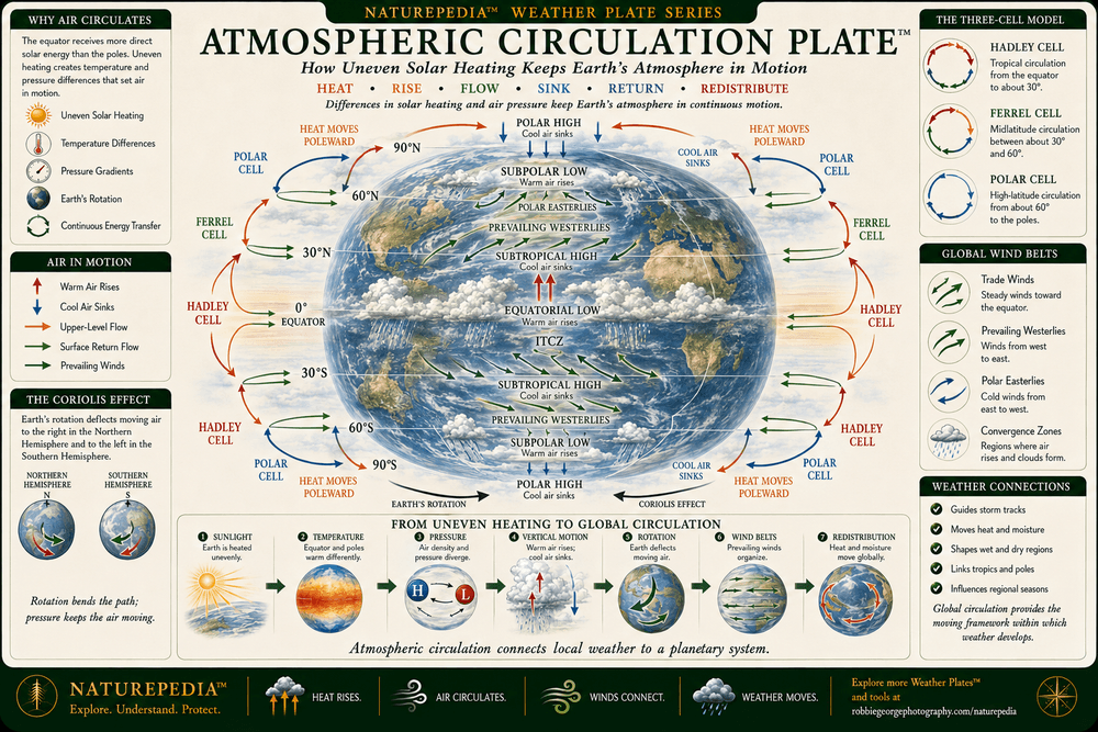
Atmospheric Circulation™ explains how uneven solar heating, temperature differences, air-pressure gradients, and Earth’s rotation keep the atmosphere in continuous motion. Warm air rises near the equator, cooler air sinks at higher latitudes, prevailing winds redistribute heat and moisture, and the Hadley, Ferrel, and Polar cells connect local weather with one planetary circulation system.

Atmospheric Circulation Plate showing uneven solar heating, equatorial and polar pressure belts, rising and sinking air, Hadley cells, Ferrel cells, Polar cells, trade winds, prevailing westerlies, polar easterlies, the Coriolis effect, and heat moving from the equator toward the poles.
Atmospheric Circulation Plate™ — a Naturepedia™ overview showing how uneven heating, pressure differences, rising and sinking air, Earth’s rotation, global circulation cells, and prevailing wind belts redistribute energy and moisture around the planet.

Visible Plate ID: weather#atmospheric-circulation-plate

Type: Naturepedia Atmospheric Circulation Plate™

Naturepedia™ Jet Stream Plate

Jet Stream Plate™

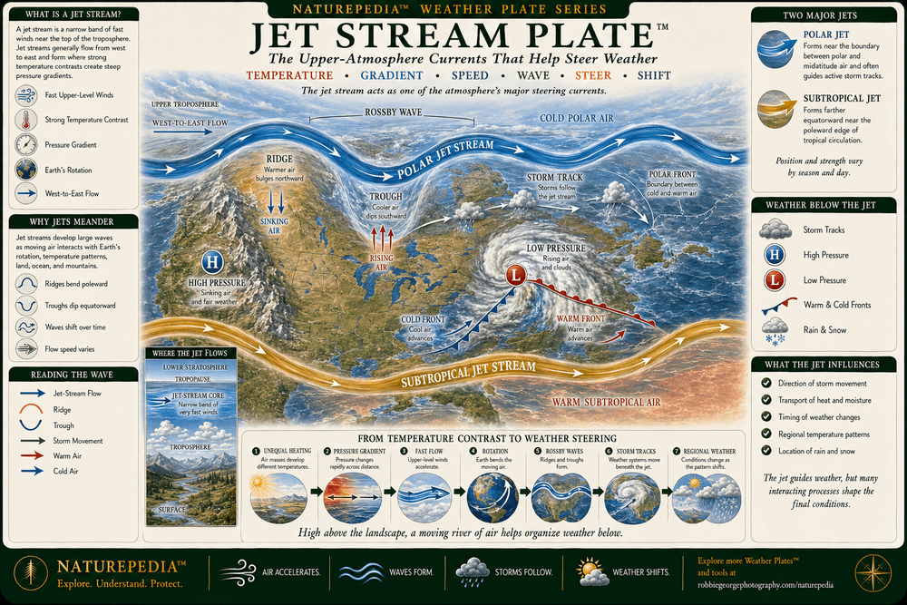
The Jet Stream™ introduces the fast-moving upper-atmosphere currents that help steer storms, separate major air masses, transport heat and moisture, and influence changing weather below. Ridges allow warmer air to extend poleward, troughs allow colder air to move equatorward, and shifting Rossby waves help organize storm tracks, pressure systems, fronts, precipitation, and regional weather patterns.

Jet Stream Plate showing the polar and subtropical jet streams, west-to-east upper-atmosphere flow, Rossby waves, ridges, troughs, cold polar air, warm subtropical air, storm tracks, high and low pressure, warm and cold fronts, rising and sinking air, rain, and snow across North America.
Jet Stream Plate™ — a Naturepedia™ overview showing how the polar and subtropical jet streams form moving upper-atmosphere pathways that influence air masses, storm tracks, pressure systems, fronts, precipitation, and regional weather.

Visible Plate ID: weather#jet-stream-plate

Type: Naturepedia Jet Stream Plate™

Naturepedia™ Storm Systems Plate

Storm Systems Plate™

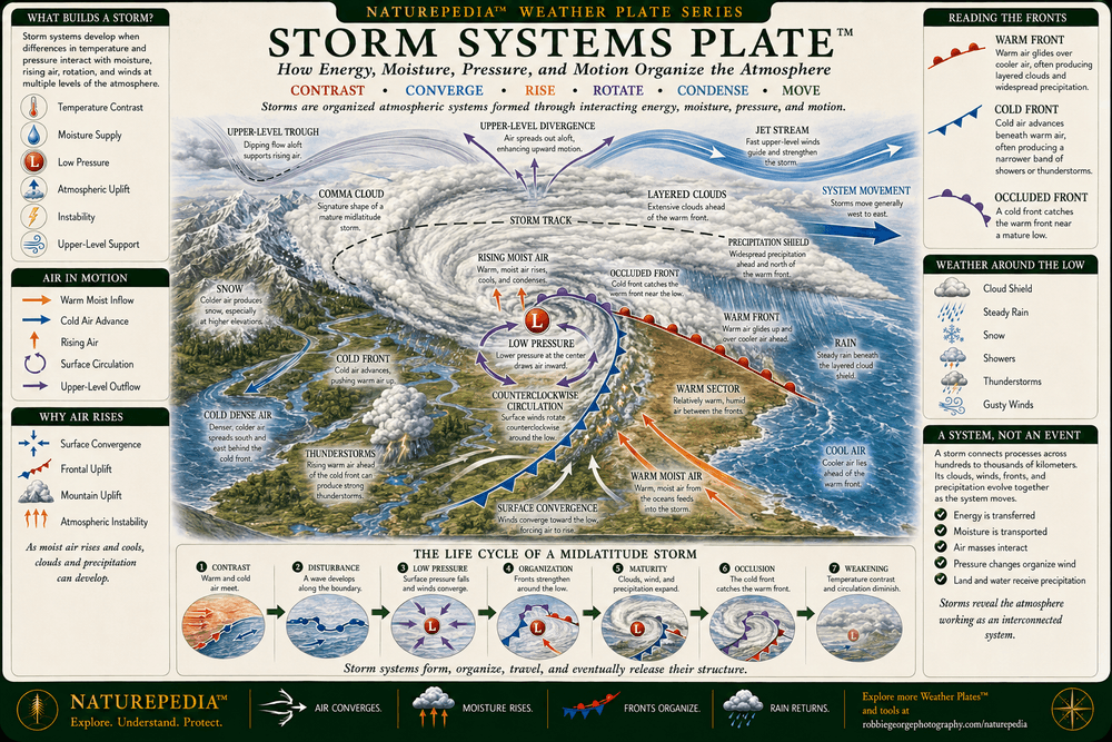
Storm Systems™ explores how contrasting air masses, atmospheric moisture, rising air, instability, pressure differences, frontal boundaries, upper-level winds, and Earth’s rotation can organize weather across large regions. Using a mature midlatitude storm as its central example, this Plate follows warm, cold, and occluded fronts as they produce clouds, wind, rain, snow, showers, and thunderstorms around a moving low-pressure system.

Storm Systems Plate showing a mature midlatitude low-pressure system with counterclockwise circulation, a comma cloud, warm front, cold front, occluded front, warm sector, rising moist air, cold dense air, cloud shield, rain, snow, thunderstorms, upper-level divergence, a jet stream, and an eastward-moving storm track.
Storm Systems Plate™ — a Naturepedia™ overview showing how air masses, moisture, uplift, instability, pressure, fronts, rotation, and upper-atmosphere support can organize a traveling midlatitude storm system.

Visible Plate ID: weather#storm-systems-plate

Type: Naturepedia Storm Systems Plate™

Naturepedia™ Clouds Plate

Clouds Plate™

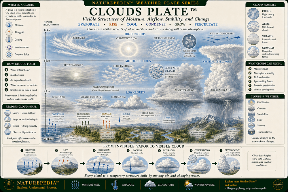
Clouds™ are visible structures formed from tiny liquid-water droplets, ice crystals, or both suspended within the atmosphere. Their altitude, shape, texture, movement, and vertical development reveal what moisture and air are doing above the landscape—providing visible evidence of atmospheric stability, rising air, approaching fronts, precipitation potential, and changing weather.

Clouds Plate showing high, middle, and low cloud families including cirrus, cirrostratus, cirrocumulus, altostratus, altocumulus, stratus, stratocumulus, cumulus, nimbostratus, and cumulonimbus, together with water vapor, rising air, cooling, condensation, rain, snow, fog, and vertical cloud development.
Clouds Plate™ — a Naturepedia™ overview organizing major cloud types by altitude, form, composition, and vertical development while showing how invisible water vapor becomes visible cloud and precipitation.

Visible Plate ID: weather#clouds-plate

Type: Naturepedia Clouds Plate™

Naturepedia™ Weather Patterns Across Scale Plate

Weather Patterns Across Scale Plate™

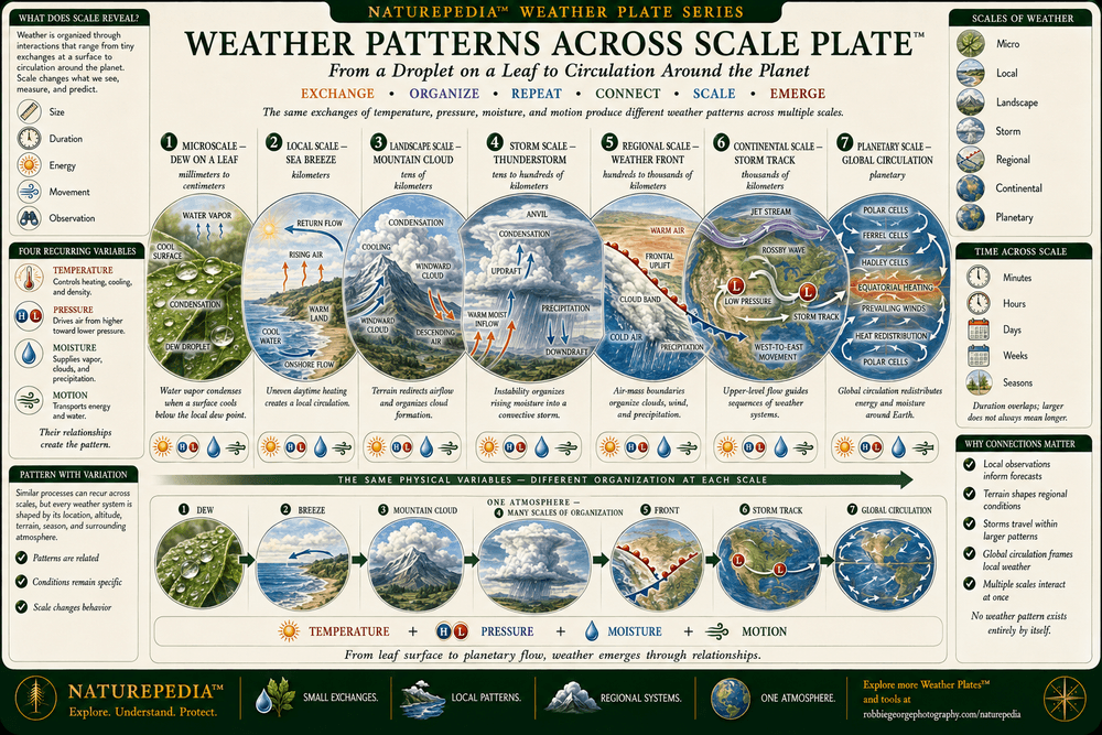
Weather Patterns Across Scale™ follows atmospheric organization from a droplet forming on a leaf to global circulation moving energy around the planet. Temperature, pressure, moisture, and motion operate at every scale, but terrain, duration, available energy, water, and surrounding conditions shape how those variables are expressed within each weather pattern.

Weather Patterns Across Scale Plate showing dew on a leaf, a sea breeze, mountain clouds, a thunderstorm, weather fronts, continental storm tracks, and global atmospheric circulation as examples of weather organization from microscopic to planetary scales.
Weather Patterns Across Scale Plate™ — a Naturepedia™ overview showing how exchanges of temperature, pressure, moisture, and motion produce related but distinct weather patterns from microscopic surfaces to planetary circulation.

Visible Plate ID: weather#weather-patterns-across-scale-plate

Type: Naturepedia Weather Patterns Across Scale Plate™

Naturepedia™ Weather & Pattern Formation Plate

Weather & Pattern Formation Plate™

Weather & Pattern Formation™ explores how interacting heat, moisture, pressure, airflow, rotation, instability, and feedback can organize the atmosphere into visible structure. Cloud streets, convection cells, precipitation bands, spiraling cyclones, wave-like fronts, branching lightning, and atmospheric vortices demonstrate how complex forms can emerge from repeated physical interactions without requiring a fixed blueprint.

Weather and Pattern Formation Plate showing how energy differences, pressure and buoyancy, moisture changes, airflow, shear, rotation, and feedback create cloud streets, convection cells, precipitation bands, spiraling cyclones, wave-like weather fronts, branching lightning, and atmospheric vortices.
Weather & Pattern Formation Plate™ — a Naturepedia™ overview showing how physical gradients, airflow, moisture, rotation, feedback, and atmospheric constraints can produce organized but continuously changing weather patterns.

Visible Plate ID: weather#weather-pattern-formation-plate

Type: Naturepedia Weather & Pattern Formation Plate™

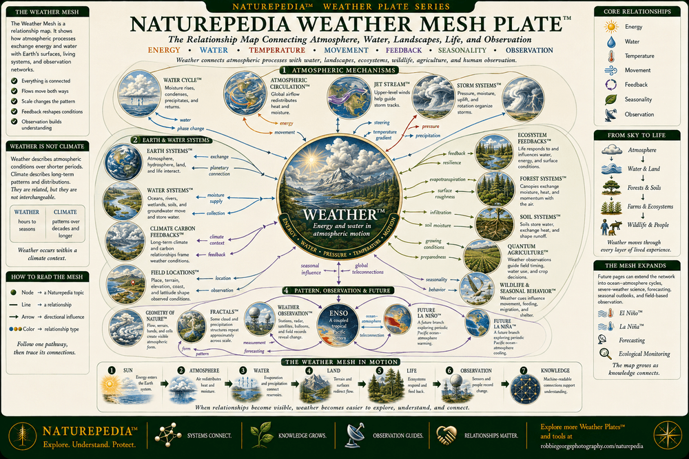
Naturepedia™ Weather Mesh Plate

Naturepedia Weather Mesh Plate™

The Naturepedia Weather Mesh™ maps Weather™ as a relationship hub connecting atmospheric mechanisms with water, landscapes, ecosystems, agriculture, wildlife, seasonal behavior, pattern formation, field observation, and future forecasting. Energy, water, temperature, movement, feedback, seasonality, and observation move through the Mesh in multiple directions, revealing how weather participates in a much larger network of Earth and living systems.

Naturepedia Weather Mesh Plate showing Weather at the center of a relationship map connected to the Water Cycle, Atmospheric Circulation, Jet Stream, Storm Systems, Earth Systems, Water Systems, Climate Carbon Feedbacks, Ecosystem Feedbacks, Forest Systems, Soil Systems, Quantum Agriculture, wildlife migration, field locations, Geometry of Nature, Fractals, weather observation, ENSO, El Niño, La Niña, and future forecasting.
Naturepedia Weather Mesh Plate™ — a relationship map connecting weather with atmospheric processes, Earth and water systems, ecosystems, forests, soils, agriculture, wildlife, field observation, natural patterns, and future weather intelligence.

Visible Plate ID: weather#naturepedia-weather-mesh-plate

Type: Naturepedia Weather Mesh Plate™

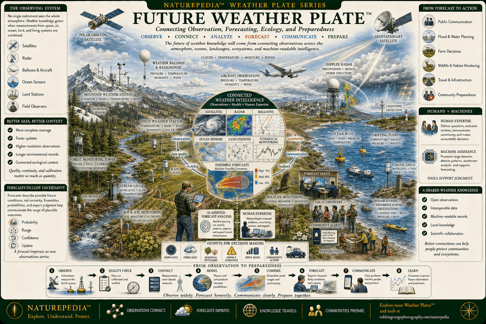
Naturepedia™ Future Weather Plate

Future Weather Plate™

Future Weather™ explores how satellites, radar, weather balloons, aircraft, ocean sensors, land stations, ecological monitoring, field observers, forecasting models, machine-assisted analysis, and human expertise can work together to improve atmospheric understanding. Better forecasts will depend not only on more data, but also on data quality, uncertainty, scientific interpretation, open communication, local knowledge, and careful decisions that help communities and ecosystems prepare.

Future Weather Plate showing polar-orbiting and geostationary satellites, radar, weather balloons, aircraft observations, mountain and field weather stations, ocean buoys, coastal gauges, forest and soil sensors, wildlife monitoring, AI-assisted forecast analysis, human expertise, public communication, and community preparedness.
Future Weather Plate™ — a Naturepedia™ overview showing how connected observations, forecasting models, machine assistance, human expertise, ecological monitoring, and clear communication can support better weather knowledge and preparedness.

Visible Plate ID: weather#future-weather-plate

Type: Naturepedia Future Weather Plate™

Creator & Field Observer

About Robbie George

Robbie George is a National Geographic–published nature photographer, writer, and creator of Naturepedia™. His field experience across Yellowstone, the Rocky Mountains, Lake Mattamuskeet, coastal ecosystems, forests, wetlands, wildlife refuges, and remote landscapes has been shaped by close observation of light, water, clouds, storms, seasonal change, wildlife behavior, and the atmospheric conditions that continually transform the natural world.

One of Robbie’s photographs from Lake Mattamuskeet was displayed at the Smithsonian National Museum of Natural History. His larger body of work connects fine-art nature photography with field-based ecological observation, helping viewers move beyond the image to understand the relationships among wildlife, habitats, weather, water, geography, behavior, and seasonality.

Robbie created Naturepedia™ as a connected knowledge system rather than a collection of isolated articles. Its Pages™, Plates™, visible semantic IDs, structured data, internal relationships, and machine-readable discovery layers are designed to connect species, ecosystems, Earth systems, field locations, natural patterns, and environmental processes through a shared architecture.

Weather™ extends that work into the atmosphere, showing how energy, water, pressure, temperature, and motion influence clouds, storms, landscapes, ecosystems, wildlife, agriculture, photography, and everyday field conditions. The page is educational and observational in purpose; official forecasts, watches, warnings, and emergency instructions should always come from qualified weather authorities.

Weather Questions Answered

Weather™ FAQ

Explore frequently asked questions about weather, clouds, wind, storms, the water cycle, atmospheric circulation, forecasting, and the difference between weather and climate.

What is weather?

Weather describes the condition of the atmosphere at a particular place and time. It includes temperature, humidity, clouds, wind, air pressure, visibility, rain, snow, fog, thunderstorms, and other atmospheric conditions that may change over minutes, hours, or days.

What is the difference between weather and climate?

Weather describes shorter-term atmospheric conditions and events, while climate describes the longer-term patterns, ranges, averages, and distributions of weather observed across seasons, decades, and regions. Weather occurs within a climate context, but the two terms are not interchangeable.

Why is the Sun the primary source of weather energy?

Solar energy warms Earth’s surface and atmosphere unevenly. Oceans, forests, mountains, deserts, snowfields, wetlands, and cities absorb and release heat differently. These temperature contrasts contribute to pressure differences, rising and sinking air, evaporation, wind, clouds, precipitation, and global atmospheric circulation.

How does the water cycle create weather?

Solar energy evaporates water from oceans, lakes, rivers, soils, and vegetation. Water vapor rises, cools, and condenses into clouds. When droplets or ice crystals grow large enough, water returns as rain, snow, or other precipitation. Runoff, groundwater, rivers, and ecosystems then move and store that water before it eventually returns to the atmosphere and ocean.

What causes wind?

Wind develops when differences in heating and air pressure set air in motion. Air generally moves from areas of higher pressure toward areas of lower pressure, while Earth’s rotation, friction, terrain, coastlines, temperature contrasts, and surrounding weather systems influence its final speed and direction.

How do clouds form?

Clouds form when moist air rises or otherwise cools until it reaches saturation. Water vapor then condenses onto tiny airborne particles or freezes into ice crystals. Cloud shape, altitude, composition, and vertical development depend on temperature, moisture, stability, airflow, and the way the air is being lifted.

What is the jet stream?

The jet stream is a relatively narrow band of fast-moving wind in the upper atmosphere, generally flowing from west to east. Strong temperature and pressure contrasts help form jet streams, while Earth’s rotation helps redirect their movement. Jet-stream ridges, troughs, and waves can influence storm tracks, air masses, fronts, precipitation, and regional weather changes.

How do storm systems form?

Storm systems form through different combinations of atmospheric energy, moisture, rising air, instability, pressure differences, air-mass contrasts, fronts, wind shear, terrain, and upper-level support. Different combinations produce different storm types, ranging from local thunderstorms to large midlatitude low-pressure systems and tropical cyclones.

Do weather patterns repeat across different scales?

Weather patterns across different scales may share physical variables such as temperature, pressure, moisture, and motion. Waves, bands, cells, spirals, branches, and vortices can appear in multiple atmospheric settings. However, natural weather patterns are not exact copies or perfect mathematical fractals. Their structures change with scale, terrain, energy, water, season, and surrounding conditions.

Can a weather forecast predict exactly what will happen?

No forecast can describe the future with complete certainty. Forecasts use observations, atmospheric models, ensembles, probability ranges, historical context, and scientific judgment to describe likely conditions and possible outcomes. Forecast accuracy generally improves as new observations arrive, but uncertainty remains an essential part of responsible weather communication.

Weather safety: Naturepedia™ provides educational and observational information, not live forecasts, watches, warnings, evacuation instructions, or emergency guidance. For current United States forecasts and alerts, consult the National Weather Service and follow instructions from local emergency authorities.

Trusted Art Seller

Trusted Art Seller

The presence of this badge signifies that this business has officially registered with the Art Storefronts Organization and has an established track record of selling art.

It also means that buyers can trust that they are buying from a legitimate business. Art sellers that conduct fraudulent activity or that receive numerous complaints from buyers will have this badge revoked. If you would like to file a complaint about this seller, please do so here.

Verified Returns & Exchanges

Verified Returns & Exchanges

The Art Storefronts Organization has verified that this business has provided a returns & exchanges policy for all art purchases.

Description of Policy from Merchant:

What is your Policy on Returns/Exchanges/Refunds? I take great pride in my work and prints, and I want you to be completely happy with your investment in my nature art. If for any reason you are unsatisfied with your print, you may return it within 14 days of delivery, and/or exchange it for another print. Prints must be returned in new condition, packaged carefully in the original packaging if possible. Your refund will be issued as soon as I receive the returned print. Please contact me if you would like to arrange a return or exchange. In the event that you receive a damaged or defective print, please let me know within 7 days of receipt, and I will arrange for a new print to be shipped to you at no additional cost.

Verified Secure Website with Safe Checkout

Verified Secure Website with Safe Checkout

This website provides a secure checkout with SSL encryption.

Verified Archival Materials Used

Verified Archival Materials Used

The Art Storefronts Organization has verified that this Art Seller has published information about the archival materials used to create their products in an effort to provide transparency to buyers.

Description from Merchant:

Fine Art Prints are made with high-quality archival inks on fine art papers using a high-resolution large format inkjet printer. Our premium archival inks produce images with smooth tones and rich colors. Prints are made with care on your choice of exquisite Fine Art Papers using a high-resolution large format inkjet printer. https://www.graphikprintworks.com

Cart

Your cart is currently empty.

Saved Successfully.

This is only visible to you because you are logged in and are authorized to manage this website. This message is not visible to other website visitors.

Import From Instagram

Click on any Image to continue

This Website Supports Augmented Reality to Live Preview Art

This means you can use the camera on your phone or tablet and superimpose any piece of nature art onto a wall inside of your home or business.

To use this feature, Just look for the "Live Preview AR" button when viewing any piece of nature art on this website!

🦊 Pounce now for 20% off

No thanks