ATTENTION: To use this site, it is necessary to enable JavaScript in your browser.
Here are the Instructions on how to enable JavaScript in your web browser.

🌿 Where Earth Creates New Worlds

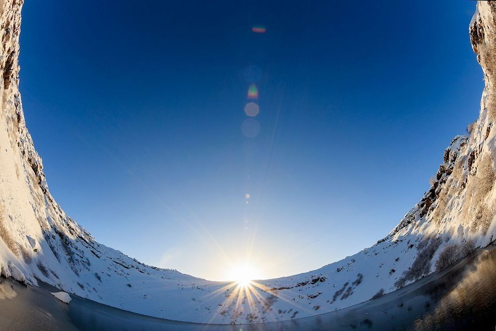
Snow-covered volcanic caldera landscape in Iceland with sunrise, crater walls, blue sky, and volcanic terrain

Naturepedia Earth Systems Layer

Volcanic Landscapes™

Where Earth Creates New Worlds

Explore volcanoes, lava flows, calderas, magma chambers, volcanic islands, volcanic soils, plate tectonics, eruption systems, volcanic biodiversity, and the geological forces that shape Earth’s most powerful landscapes.

Explore Volcanic Landscapes

Naturepedia Volcanic Earth Systems Hub

Where Fire, Stone, Water, and Life Converge

Volcanic Landscapes™ explores the powerful Earth systems that build mountains, islands, lava fields, calderas, fertile soils, geothermal regions, and new ecosystems. These landscapes reveal how magma, heat, pressure, plate tectonics, water, minerals, and time continually reshape the surface of our planet.

I photographed the hero image on this page inside Kerið Crater in Iceland, one of the country's most striking volcanic landforms. Standing on the floor of the caldera, surrounded by steep volcanic walls carved by geological forces and softened by snow, I was reminded that volcanic landscapes are far more than scenes of destruction. They are places where geology, climate, water, and life intersect to create entirely new environments.

Volcanoes are among Earth's greatest landscape architects. They create new islands, build mountains, enrich soils, power geothermal systems, influence biodiversity, and shape ecosystems across entire regions. Even long after eruptions end, their influence remains visible through calderas, lava fields, volcanic forests, crater lakes, and some of the most productive landscapes on Earth.

This Naturepedia™ page connects Hydrothermal Ecosystems™, Geothermal Ecosystems™, Yellowstone Thermal Features™, Microbial Life Systems™, Water Systems™, and Biodiversity & Ecosystem Balance™ into a broader Earth Systems framework focused on volcanoes, lava, calderas, tectonics, biodiversity, ecological succession, planetary geology, and the forces that continue shaping Earth today.

Explore Volcanic Landscapes™

Volcanic Landscapes Plate™
The master systems map for volcano-shaped worlds.
What Are Volcanic Landscapes?
How magma, lava, ash, water, and time shape terrain.
Volcano Identification Plate™
Shield volcanoes, stratovolcanoes, cinder cones, and calderas.
Lava Flows Plate™
Pahoehoe, aa, basaltic flows, and lava fields.
Volcanic Eruptions Plate™
Explosive eruptions, effusive eruptions, ash, gas, and lava.
Calderas Plate™
Collapse systems, crater lakes, Yellowstone, and volcanic basins.
Magma Chambers Plate™
Subsurface magma systems and volcanic plumbing.
Volcanic Soils Plate™
Mineral fertility, soil formation, and ecosystem renewal.
Volcanic Ecosystems Plate™
Life adapting to lava fields, volcanic slopes, and geothermal zones.
Volcanic Succession Plate™
Bare rock, pioneer species, soils, shrubs, and forests.
Volcanic Biodiversity Plate™
Endemic species, adaptation, and life on volcanic terrain.
Volcanic Islands Plate™
Hawaii, Iceland, Galápagos, hotspots, and island building.
Plate Tectonics Plate™
Subduction, rifting, hotspots, mantle plumes, and crust movement.
Ring of Fire Plate™
Pacific volcano chains, earthquakes, and global volcanic activity.
Supervolcanoes Plate™
Yellowstone, Toba, Taupo, and large-scale eruption systems.
Volcanic Hazards Plate™
Ash fall, pyroclastic flows, lahars, gases, and risk systems.
Volcanic Photography Plate™
Lava, eruptions, crater landscapes, safety, and field imaging.
Volcanoes Beyond Earth Plate™
Mars, Venus, Io, cryovolcanoes, and planetary geology.
Related Naturepedia Systems™
Hydrothermal, geothermal, water, biodiversity, and Earth Systems links.

Naturepedia Systems Plate

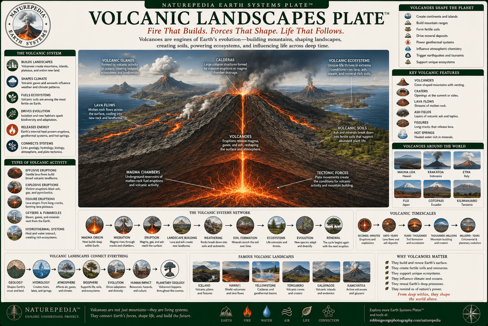
Volcanic Landscapes Plate™

This master systems plate introduces Volcanic Landscapes™ as one of Naturepedia’s major Earth Systems layers. It connects volcanoes, lava flows, calderas, magma chambers, volcanic soils, volcanic islands, plate tectonics, eruption systems, biodiversity, hazards, photography, and planetary geology into one visible knowledge framework.

Volcanic Landscapes Plate showing volcanoes, lava flows, calderas, magma chambers, volcanic islands, volcanic soils, plate tectonics, eruptions, biodiversity, hazards, and planetary geology
Volcanic Landscapes Plate™ — a Naturepedia™ systems layer showing how magma, lava, tectonics, calderas, volcanic soils, ecosystems, hazards, and planetary geology shape new worlds on Earth and beyond.

Earth’s Creative Fire

Volcanic landscapes form where magma, heat, pressure, gases, and tectonic forces reshape Earth’s surface through eruptions, lava flows, ash deposits, and collapsing calderas.

New Ecosystems

After volcanic disturbance, life returns through weathering, microbial activity, pioneer species, soil formation, plant succession, wildlife colonization, and long-term ecosystem renewal.

Planetary Geology

Volcanoes are not only Earth features. Volcanic systems also shape Mars, Venus, Io, icy moons, and other planetary bodies across the Solar System.

Visible Plate ID

ID: volcanic-landscapes#volcanic-landscapes-plate

URL: https://www.robbiegeorgephotography.com/volcanic-landscapes

Type: Naturepedia Systems Plate™

Volcanic Earth Systems

What Are Volcanic Landscapes?

Volcanic landscapes are regions shaped by magma, lava, ash, gases, tectonic forces, erosion, water, ice, and time. They include volcanoes, lava fields, calderas, craters, volcanic islands, geothermal regions, basalt plains, ash deposits, and fertile soils formed from weathered volcanic rock.

These landscapes begin deep inside Earth, where heat and pressure generate magma beneath the crust. As magma rises through fractures and volcanic plumbing systems, it may erupt as lava, ash, steam, gas, or explosive pyroclastic material. Each eruption adds new rock, reshapes terrain, and leaves behind geological evidence of Earth’s internal energy.

Over time, volcanic landscapes become living systems. Fresh lava cools into rock, ash breaks down into mineral-rich soil, microbes colonize bare surfaces, pioneer plants take root, and ecosystems slowly develop across once-barren terrain. In this way, volcanoes destroy and create at the same time.

Volcanic landscapes also connect directly to Hydrothermal Ecosystems™, Geothermal Ecosystems™, Yellowstone Thermal Features™, and future Earth Systems™ because they reveal how geology, water, heat, chemistry, climate, biodiversity, and planetary processes work together.

Geological Creation

Volcanoes build mountains, islands, lava fields, calderas, basalt plains, craters, and new crust through eruptions and magma-driven processes.

Ecological Renewal

After eruptions, volcanic terrain becomes a living laboratory for succession, soil formation, microbial colonization, plant growth, and biodiversity.

Planetary Pattern

Volcanic landscapes are found across Earth and beyond, from Iceland and Hawaii to Mars, Venus, Io, and other worlds shaped by internal heat.

Naturepedia Insight: Volcanic landscapes show Earth in the act of becoming. They are not static scenery, but active records of heat, motion, destruction, renewal, and the long transformation from molten rock into living ecosystems.

Naturepedia Identification Plate

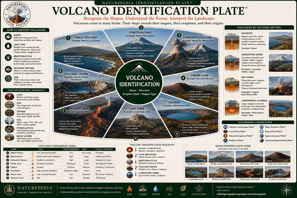
Volcano Identification Plate™

Volcanoes occur in many forms depending on magma composition, eruption style, tectonic setting, and geological history. This identification plate introduces the major volcano types found across Earth, helping readers recognize the structures, shapes, and processes that create volcanic landscapes.

Volcano Identification Plate showing shield volcanoes, stratovolcanoes, cinder cones, calderas, lava domes, fissure vents, and volcanic landforms
Volcano Identification Plate™ — a Naturepedia™ guide to recognizing the major volcano types and volcanic landforms found around the world.

Not all volcanoes look alike. Some rise as towering snow-capped peaks, while others spread across the landscape as broad volcanic shields. Some erupt violently with ash and pyroclastic flows, while others release relatively gentle rivers of lava. The shape of a volcano often reflects the chemistry of its magma and the style of eruptions that built it.

Shield volcanoes form from fluid basaltic lava that spreads outward in broad layers. Stratovolcanoes, also known as composite volcanoes, build steep-sided mountains through alternating layers of lava, ash, and volcanic debris. Cinder cones form from explosive eruptions that scatter volcanic fragments around a vent, while calderas develop when large magma chambers collapse after major eruptions.

Learning to identify volcano types provides insight into eruption hazards, geological history, tectonic processes, and the forces shaping volcanic landscapes. These landforms serve as visible records of Earth’s internal energy and ongoing geological activity.

Shield Volcanoes

Broad volcanoes formed by fluid basaltic lava flows. Hawaii contains some of the world’s most famous shield volcanoes.

Stratovolcanoes

Steep-sided composite volcanoes built from alternating layers of lava, ash, and pyroclastic material.

Calderas & Cones

Collapse calderas and cinder cones reveal different eruption histories and volcanic processes across time.

Naturepedia Insight: Every volcano tells a different geological story. Its shape, size, structure, and eruption style reveal clues about the magma beneath it and the tectonic forces operating deep within Earth.

Visible Plate ID

ID: volcanic-landscapes#volcano-identification-plate

URL: https://www.robbiegeorgephotography.com/volcanic-landscapes

Type: Naturepedia Identification Plate™

Naturepedia Geology Plate

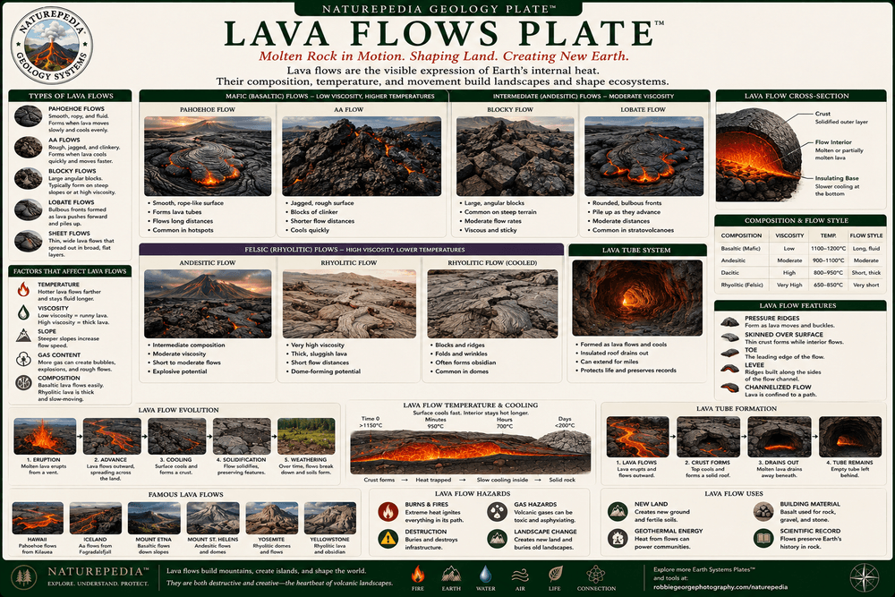
Lava Flows Plate™

Lava flows are among the most recognizable features of volcanic landscapes. As molten rock reaches Earth's surface, it spreads across the terrain, creating lava fields, volcanic plains, lava tubes, new coastlines, and the foundation for future ecosystems.

Lava Flows Plate showing pahoehoe lava, aa lava, basaltic lava fields, lava tubes, cooling lava, and volcanic landforms
Lava Flows Plate™ — a Naturepedia™ exploration of molten rock, volcanic land formation, lava textures, and the processes that build new landscapes.

Lava is magma that has reached Earth's surface. Once erupted, it begins cooling and solidifying while flowing across the landscape. The distance lava travels depends on its temperature, chemistry, gas content, slope, and eruption rate. Some lava flows move only a few hundred feet, while others travel many miles before cooling completely.

Basaltic lava tends to be fluid and mobile, producing broad lava fields and shield volcanoes. More silica-rich lava is thicker and moves more slowly, often creating lava domes and steeper volcanic features. As lava cools, it develops distinctive textures that help geologists interpret eruption history and volcanic processes.

Lava flows are also landscape builders. They create new islands, extend coastlines, fill valleys, generate lava tubes, and provide the raw material that eventually weathers into volcanic soils. Over decades and centuries, these hardened lava surfaces become the foundation for entirely new ecosystems.

Pahoehoe Lava

Smooth, rope-like lava formed by fluid basaltic flows that cool gradually while remaining mobile.

Aa Lava

Rough, jagged lava with broken surfaces created when lava cools and fragments during movement.

Lava Tubes

Underground channels formed when the outer surface hardens while molten lava continues flowing beneath.

Naturepedia Insight: Every lava flow represents a moment when Earth’s interior became visible at the surface. As molten rock cools into stone, it creates the geological foundation upon which future soils, ecosystems, and landscapes will develop.

Visible Plate ID

ID: volcanic-landscapes#lava-flows-plate

URL: https://www.robbiegeorgephotography.com/volcanic-landscapes

Type: Naturepedia Geology Plate™

Naturepedia Geology Plate

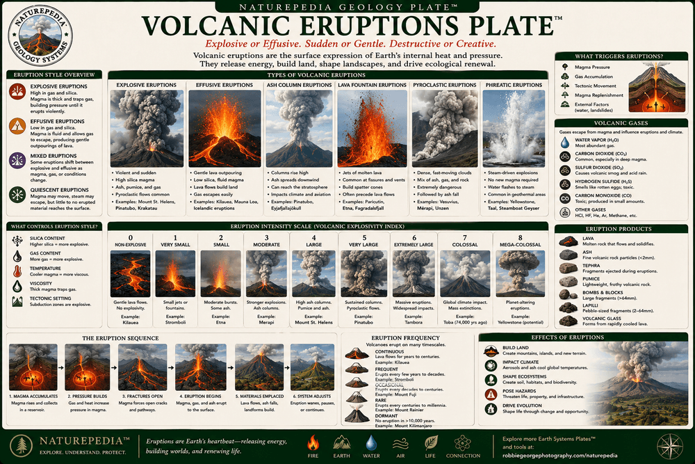
Volcanic Eruptions Plate™

Volcanic eruptions are the visible expression of Earth's internal energy. They occur when magma, gases, ash, and fragmented rock escape from beneath the crust, releasing heat and material that can rapidly transform landscapes and influence ecosystems, climate, and human societies.

Volcanic Eruptions Plate showing explosive eruptions, effusive eruptions, ash clouds, lava fountains, volcanic gases, and eruption processes
Volcanic Eruptions Plate™ — a Naturepedia™ exploration of eruption styles, volcanic energy release, ash production, lava emplacement, and landscape transformation.

Volcanic eruptions occur when pressure builds within magma chambers beneath Earth's surface. As magma rises, dissolved gases expand and seek escape pathways through fractures, vents, and volcanic conduits. The interaction between magma chemistry, gas content, and pressure determines whether an eruption will be gentle or explosive.

Effusive eruptions release fluid lava that flows steadily across the landscape. These eruptions commonly build shield volcanoes and extensive lava fields. Explosive eruptions, by contrast, eject ash, volcanic bombs, pumice, and gases high into the atmosphere, often creating dramatic eruption columns and widespread ash deposits.

Eruptions are among the most powerful geological events on Earth. They construct mountains, generate new islands, influence weather patterns, enrich soils with minerals, and sometimes reshape entire regions in a matter of days. Their effects can persist for centuries through geological and ecological change.

Effusive Eruptions

Gentle eruptions dominated by flowing lava that gradually builds volcanic landscapes and lava fields.

Explosive Eruptions

Violent eruptions that fragment magma into ash, pumice, and volcanic debris capable of traveling vast distances.

Volcanic Gases

Water vapor, carbon dioxide, sulfur dioxide, and other gases drive eruption dynamics and influence atmospheric conditions.

Naturepedia Insight: Every volcanic eruption represents a direct connection between Earth's deep interior and its surface. Through lava, ash, and gases, the planet continuously reshapes itself, creating new terrain while revealing the powerful geological forces operating beneath our feet.

Visible Plate ID

ID: volcanic-landscapes#volcanic-eruptions-plate

URL: https://www.robbiegeorgephotography.com/volcanic-landscapes

Type: Naturepedia Geology Plate™

Naturepedia Geology Plate

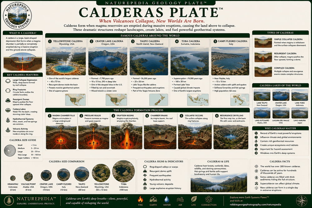
Calderas Plate™

Calderas are among the largest and most dramatic volcanic landforms on Earth. Formed when massive eruptions empty underlying magma chambers and the ground collapses inward, calderas create enormous volcanic basins that can span miles across and shape entire landscapes.

Calderas Plate showing volcanic calderas, collapse basins, crater lakes, Yellowstone, Crater Lake, magma chambers, and volcanic landforms
Calderas Plate™ — a Naturepedia™ exploration of collapse structures, volcanic basins, magma chamber dynamics, crater lakes, and some of Earth's largest volcanic systems.

Unlike volcanic craters, which form around individual vents, calderas develop when large volumes of magma are removed from beneath the surface. As the magma chamber empties during a major eruption, the overlying rock loses support and collapses inward, creating a broad depression that may span several miles in diameter.

Some of Earth's most famous volcanic landscapes are calderas. Yellowstone National Park sits atop one of the world's largest active caldera systems. Crater Lake in Oregon occupies a spectacular water-filled caldera formed after the collapse of Mount Mazama approximately 7,700 years ago. Iceland, New Zealand, Indonesia, and many other volcanic regions also contain major caldera systems.

Although calderas often form through catastrophic eruptions, they frequently become centers of long-term geological activity. Many contain geothermal systems, hot springs, lakes, volcanic domes, and fertile ecosystems that persist long after the original eruption has ended.

Collapse Structures

Calderas form when magma chambers empty and the surface collapses into the void left beneath the crust.

Crater Lakes

Many calderas eventually fill with water, creating some of the world's deepest and most beautiful lakes.

Ongoing Activity

Even after collapse, calderas often remain geologically active through geothermal systems, uplift, and renewed volcanism.

Naturepedia Insight: Calderas are reminders that some of Earth's largest volcanic features are not mountains, but giant collapse structures created when the land above a magma chamber sinks inward. Many of the planet's most spectacular volcanic landscapes began not with growth, but with collapse.

Visible Plate ID

ID: volcanic-landscapes#calderas-plate

URL: https://www.robbiegeorgephotography.com/volcanic-landscapes

Type: Naturepedia Geology Plate™

Naturepedia Earth Systems Plate

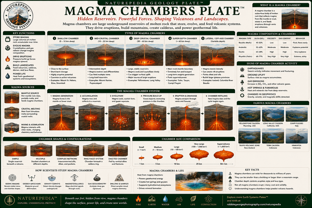
Magma Chambers Plate™

Magma chambers are the hidden engines of volcanic landscapes. Located beneath Earth's surface, these reservoirs of molten rock store heat, gases, minerals, and magma that eventually fuel eruptions, geothermal systems, volcanic mountains, calderas, and many of the planet's most dynamic geological processes.

Magma Chambers Plate showing underground magma reservoirs, volcanic plumbing systems, rising magma, heat sources, and Earth system processes
Magma Chambers Plate™ — a Naturepedia™ exploration of subsurface magma reservoirs, volcanic plumbing systems, geothermal heat, and the hidden foundations of volcanic activity.

Most volcanic activity begins deep underground within magma chambers. These reservoirs form when molten rock rises from Earth's mantle or lower crust and accumulates beneath the surface. Over time, magma chambers may grow, cool, crystallize, recharge with new magma, or migrate through complex networks of fractures and conduits.

Contrary to popular illustrations, magma chambers are rarely simple underground pools of liquid rock. Many consist of partially molten zones containing mixtures of magma, crystals, gases, and solid rock. These complex systems evolve continuously as heat and pressure change through time.

Magma chambers supply energy not only for volcanic eruptions but also for geothermal regions, hydrothermal systems, hot springs, fumaroles, geysers, and volcanic landscapes across the world. Understanding these hidden reservoirs helps scientists better interpret volcanic hazards, eruption forecasting, and Earth’s internal heat engine.

Magma Reservoirs

Subsurface storage zones where molten rock accumulates before feeding eruptions and volcanic systems.

Volcanic Plumbing

Networks of conduits, fractures, dikes, and vents transport magma from depth toward Earth's surface.

Geothermal Energy

Heat from magma chambers powers geothermal ecosystems, hydrothermal circulation, geysers, and hot springs.

Naturepedia Insight: Magma chambers are among Earth's most important hidden systems. Though rarely seen directly, they provide the heat and energy responsible for volcanoes, calderas, geothermal landscapes, hydrothermal ecosystems, and many of the geological processes that continually reshape the planet.

Visible Plate ID

ID: volcanic-landscapes#magma-chambers-plate

URL: https://www.robbiegeorgephotography.com/volcanic-landscapes

Type: Naturepedia Earth Systems Plate™

Naturepedia Ecosystem Processes Plate

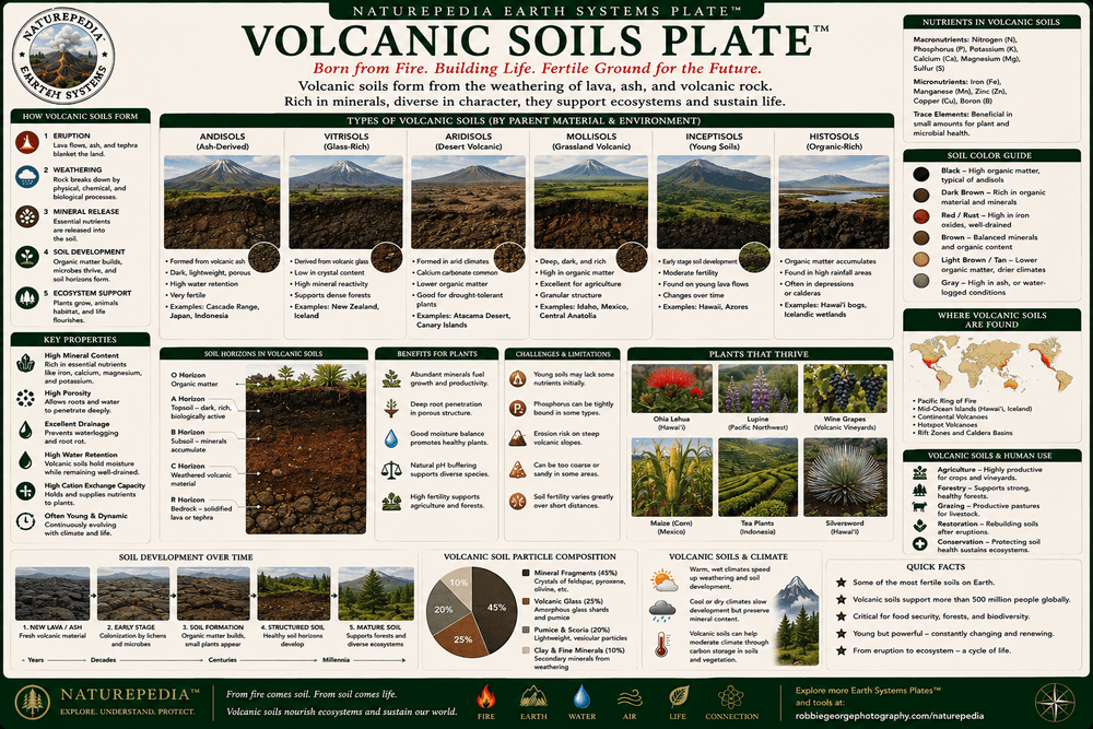
Volcanic Soils Plate™

Volcanic soils are among the most productive and biologically important soils on Earth. Formed through the weathering of lava, ash, and volcanic rock, these soils provide the foundation for forests, grasslands, agriculture, biodiversity, and ecosystem recovery following volcanic eruptions.

Volcanic Soils Plate showing volcanic ash soils, mineral-rich earth, weathering processes, plant growth, nutrient cycling, and ecosystem development
Volcanic Soils Plate™ — a Naturepedia™ exploration of soil formation, mineral enrichment, nutrient cycling, ecosystem development, and agricultural productivity in volcanic regions.

Fresh lava and volcanic ash may initially appear barren, but they contain many of the minerals needed to support future ecosystems. Through weathering, rainfall, temperature changes, microbial activity, and plant colonization, volcanic rock slowly breaks down into soil capable of sustaining increasingly complex forms of life.

Volcanic soils often contain abundant potassium, phosphorus, calcium, magnesium, iron, and trace minerals. These nutrients support plant growth and help explain why some of the world's most productive agricultural regions occur near volcanic landscapes. Vineyards, coffee plantations, forests, and grasslands frequently thrive on soils derived from volcanic materials.

The development of volcanic soils represents a critical transition from geology to ecology. As minerals become available and organic matter accumulates, soils support microbes, fungi, plants, insects, wildlife, and entire ecosystems. In this way, volcanic eruptions ultimately create the conditions for biological renewal.

Mineral Enrichment

Volcanic rocks contribute essential nutrients that become available as lava and ash weather into soil.

Soil Formation

Weathering, microbes, fungi, water, and organic matter gradually transform volcanic rock into living soil.

Ecological Foundation

Volcanic soils support biodiversity, ecosystem succession, forests, agriculture, and long-term landscape recovery.

Naturepedia Insight: One of nature's greatest transformations occurs when molten rock becomes fertile soil. Volcanic soils demonstrate how geological destruction can ultimately lead to biological abundance, supporting entire ecosystems for centuries after an eruption.

Visible Plate ID

ID: volcanic-landscapes#volcanic-soils-plate

URL: https://www.robbiegeorgephotography.com/volcanic-landscapes

Type: Naturepedia Ecosystem Processes Plate™

Naturepedia Ecosystem Plate

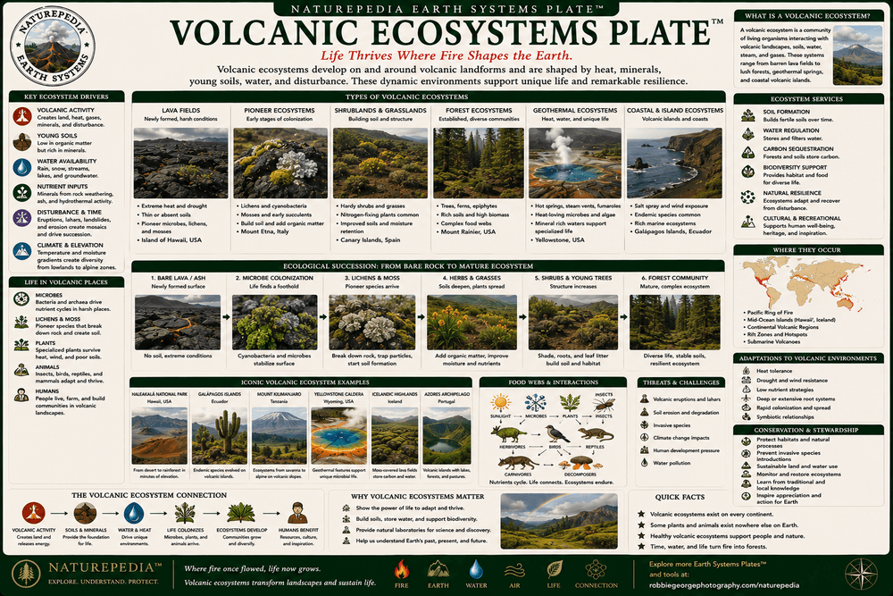
Volcanic Ecosystems Plate™

Volcanic ecosystems emerge where life adapts to landscapes shaped by eruptions, lava flows, geothermal activity, ash deposits, and volcanic soils. These environments reveal how ecosystems recover, diversify, and thrive on terrain created directly by Earth's internal forces.

Volcanic Ecosystems Plate showing volcanic forests, lava field habitats, geothermal ecosystems, wildlife adaptation, succession, and biodiversity
Volcanic Ecosystems Plate™ — a Naturepedia™ exploration of life on volcanic terrain, ecosystem development, wildlife adaptation, geothermal habitats, and ecological resilience.

Volcanic landscapes may begin as barren rock, ash, and lava, but they rarely remain lifeless for long. Microbes, fungi, lichens, mosses, and pioneer plants gradually colonize newly formed terrain, beginning the process of ecosystem development. Over time, soils form, plant communities expand, and increasingly complex food webs emerge.

Many volcanic ecosystems occur near geothermal features, lava fields, calderas, volcanic islands, and mountain slopes. These environments often support unique combinations of plants and animals adapted to mineral-rich soils, geothermal heat, unstable terrain, and periodic disturbance from volcanic activity.

Volcanic ecosystems demonstrate one of nature's most remarkable abilities: ecological resilience. Even after large eruptions, life gradually returns and rebuilds. The same volcanic forces that temporarily disrupt ecosystems also create new habitats, fertile soils, and opportunities for biodiversity to expand across the landscape.

Geothermal Habitats

Heat, minerals, and groundwater create specialized ecological zones that support unique communities of plants and microorganisms.

Ecological Recovery

Following eruptions, life gradually returns through succession, soil development, colonization, and ecosystem rebuilding.

Wildlife Adaptation

Animals inhabiting volcanic regions adapt to rugged terrain, changing habitats, geothermal influences, and mineral-rich environments.

Naturepedia Insight: Volcanic ecosystems reveal one of the most important lessons in nature: destruction and creation are often part of the same process. The forces that reshape landscapes through fire and eruption also provide the foundation for future ecosystems and biodiversity.

Visible Plate ID

ID: volcanic-landscapes#volcanic-ecosystems-plate

URL: https://www.robbiegeorgephotography.com/volcanic-landscapes

Type: Naturepedia Ecosystem Plate™

Naturepedia Ecological Succession Plate

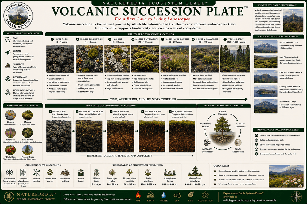
Volcanic Succession Plate™

Volcanic succession is the process by which life returns to newly formed volcanic terrain. Beginning with bare rock and ash, ecosystems gradually develop through colonization, soil formation, plant establishment, and increasing biodiversity until mature ecological communities emerge.

Volcanic Succession Plate showing bare rock, lichens, mosses, pioneer species, soil development, shrubs, forests, and ecosystem succession
Volcanic Succession Plate™ — a Naturepedia™ exploration of how life transforms fresh volcanic rock into thriving ecosystems over time.

Immediately after an eruption, volcanic landscapes may appear lifeless. Lava flows, ash deposits, and volcanic debris create surfaces with little organic matter and few resources for plants or animals. Yet succession often begins surprisingly quickly as microbes, fungi, lichens, and mosses colonize exposed rock.

These pioneer organisms help break down rock and trap organic material, contributing to the formation of soil. As conditions improve, grasses, shrubs, and hardy plants establish themselves. Their roots stabilize the developing soil while adding nutrients and habitat for insects and other organisms.

Over decades, centuries, or even millennia, volcanic landscapes may support forests, wetlands, grasslands, and complex ecological communities. Each stage of succession builds upon the previous one, transforming a geological surface into a living ecosystem capable of supporting extraordinary biodiversity.

Pioneer Species

Lichens, mosses, microbes, and fungi are often the first organisms to colonize fresh volcanic surfaces.

Soil Development

Weathering and biological activity gradually convert volcanic rock into soil capable of supporting plant life.

Mature Ecosystems

Through time, succession may lead to forests, diverse habitats, and stable ecological communities.

Naturepedia Insight: Volcanic succession is one of nature's clearest demonstrations that life can begin with almost nothing. From bare rock and ash, ecosystems emerge step by step, showing how biological communities build complexity through time.

Visible Plate ID

ID: volcanic-landscapes#volcanic-succession-plate

URL: https://www.robbiegeorgephotography.com/volcanic-landscapes

Type: Naturepedia Ecological Succession Plate™

Naturepedia Biodiversity Plate

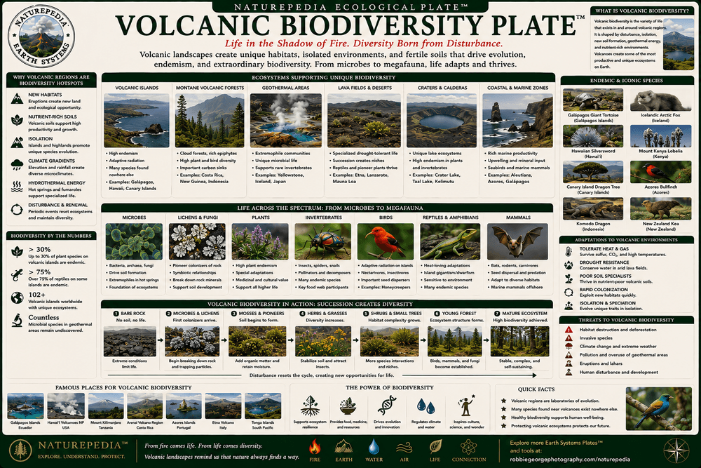
Volcanic Biodiversity Plate™

Volcanic regions support remarkable biodiversity. From isolated islands and geothermal valleys to volcanic mountains and lava fields, these landscapes create opportunities for adaptation, speciation, ecological innovation, and the evolution of unique plant and animal communities.

Volcanic Biodiversity Plate showing endemic species, volcanic island wildlife, adaptive radiation, ecological niches, and biodiversity patterns
Volcanic Biodiversity Plate™ — a Naturepedia™ exploration of endemic species, ecological adaptation, evolutionary pathways, and biodiversity in volcanic landscapes.

Volcanic landscapes often function as natural laboratories of evolution. Newly formed islands, isolated volcanic mountains, and recently disturbed habitats provide opportunities for species to colonize, adapt, diversify, and occupy ecological niches that may not exist elsewhere. Over time, these conditions can lead to the emergence of unique species found nowhere else on Earth.

Some of the world's most famous examples of biodiversity are associated with volcanic regions. The Galápagos Islands helped inspire Charles Darwin's ideas about evolution. Hawaii contains extraordinary numbers of endemic species that evolved in geographic isolation. Iceland, Yellowstone, volcanic regions of Indonesia, and other active landscapes also support distinctive ecological communities.

Volcanic biodiversity illustrates how geological processes influence biological evolution. By creating new habitats, isolating populations, altering environmental conditions, and driving ecological succession, volcanic activity becomes a powerful force shaping life itself.

Endemic Species

Many volcanic regions contain species that evolved in isolation and occur nowhere else on Earth.

Adaptive Radiation

New habitats created by volcanic activity often encourage species diversification and evolutionary innovation.

Geology & Evolution

Volcanic landscapes influence biodiversity by creating ecological opportunities and shaping evolutionary pathways.

Naturepedia Insight: Biodiversity is not shaped by biology alone. Volcanic landscapes demonstrate how geology can influence evolution, creating new worlds where life adapts, diversifies, and develops entirely new ecological possibilities.

Visible Plate ID

ID: volcanic-landscapes#volcanic-biodiversity-plate

URL: https://www.robbiegeorgephotography.com/volcanic-landscapes

Type: Naturepedia Biodiversity Plate™

Naturepedia Earth Systems Plate

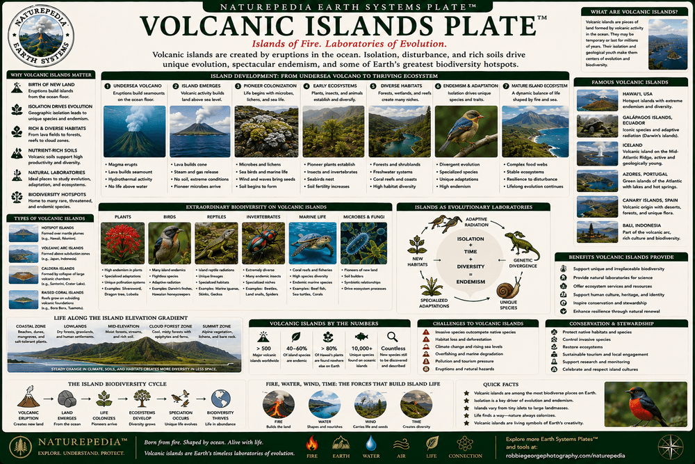
Volcanic Islands Plate™

Volcanic islands are among Earth's most extraordinary geological creations. Built by eruptions rising from the seafloor, these islands reveal how volcanic activity can create entirely new landscapes, ecosystems, habitats, and evolutionary pathways in the middle of the ocean.

Volcanic Islands Plate showing Hawaii, Iceland, Galapagos, hotspots, seafloor volcanism, island formation, and oceanic geology
Volcanic Islands Plate™ — a Naturepedia™ exploration of island formation, hotspots, oceanic volcanism, biodiversity, and some of Earth's most dynamic landscapes.

Most volcanic islands begin far below the ocean surface. Repeated eruptions build layers of lava and volcanic material that gradually accumulate until they rise above sea level. Over time, these islands may continue growing through additional eruptions or slowly erode through the action of waves, wind, glaciers, and weather.

Some volcanic islands form above hotspots, where plumes of hot mantle material rise toward the surface. Hawaii is one of the best-known examples. Others form along tectonic boundaries where plates diverge or converge. Iceland, for example, sits atop both a hotspot and the Mid-Atlantic Ridge, making it one of the most volcanically active regions on Earth.

Volcanic islands often become centers of ecological and evolutionary innovation. Their isolation allows species to adapt independently, leading to high levels of endemism and biodiversity. Over millions of years, these islands become natural laboratories where geology, ecology, and evolution interact in extraordinary ways.

Hotspot Islands

Chains such as Hawaii form as tectonic plates move over long-lived mantle plumes beneath the crust.

Oceanic Construction

Volcanic islands grow through repeated eruptions that build mountain-sized structures from the seafloor upward.

Evolutionary Laboratories

Isolation encourages biodiversity, adaptation, and the evolution of unique species found nowhere else on Earth.

Naturepedia Insight: Volcanic islands demonstrate that Earth is still creating new land. Rising from the ocean through fire and magma, these islands become living examples of how geology shapes ecosystems, biodiversity, and the course of evolution itself.

Visible Plate ID

ID: volcanic-landscapes#volcanic-islands-plate

URL: https://www.robbiegeorgephotography.com/volcanic-landscapes

Type: Naturepedia Earth Systems Plate™

Naturepedia Earth Systems Plate

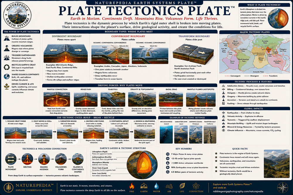
Plate Tectonics Plate™

Plate tectonics is the driving force behind most of Earth's volcanic activity. The movement of massive crustal plates creates volcanoes, mountain ranges, ocean basins, earthquakes, hydrothermal systems, and many of the geological processes that continually reshape the planet.

Plate Tectonics Plate showing tectonic plates, subduction zones, rifting, hotspots, mantle plumes, volcanoes, and Earth system processes
Plate Tectonics Plate™ — a Naturepedia™ exploration of moving tectonic plates, subduction zones, rifting, mantle plumes, volcanism, and Earth's geological engine.

Earth's outer shell is divided into massive tectonic plates that slowly move across the planet's surface. Although their movement is typically measured in inches per year, the cumulative effects over millions of years create continents, oceans, mountain ranges, volcanic arcs, and some of the largest geological features on Earth.

Most volcanoes occur where tectonic plates interact. At convergent boundaries, one plate may descend beneath another through subduction, generating magma that fuels volcanic mountain chains. At divergent boundaries, plates pull apart, allowing magma to rise and create new crust. In other regions, mantle plumes form hotspots that produce volcanic chains such as the Hawaiian Islands.

Plate tectonics connects nearly every major Earth system. It influences volcanic landscapes, hydrothermal ecosystems, earthquakes, ocean circulation, mountain building, biodiversity patterns, and even long-term climate processes. Understanding volcanism ultimately requires understanding the movement of Earth's plates.

Subduction Zones

One tectonic plate sinks beneath another, generating magma and creating volcanic mountain chains.

Rifting & Spreading

Plates moving apart allow magma to rise, creating new crust along mid-ocean ridges and rift systems.

Hotspots

Mantle plumes rising from deep within Earth generate volcanic chains independent of plate boundaries.

Naturepedia Insight: Volcanoes are not isolated features. Most are surface expressions of a much larger Earth system operating deep beneath the crust. Plate tectonics is the planetary engine that powers much of Earth's volcanism, mountain building, and geological change.

Visible Plate ID

ID: volcanic-landscapes#plate-tectonics-plate

URL: https://www.robbiegeorgephotography.com/volcanic-landscapes

Type: Naturepedia Earth Systems Plate™

Naturepedia Earth Systems Plate

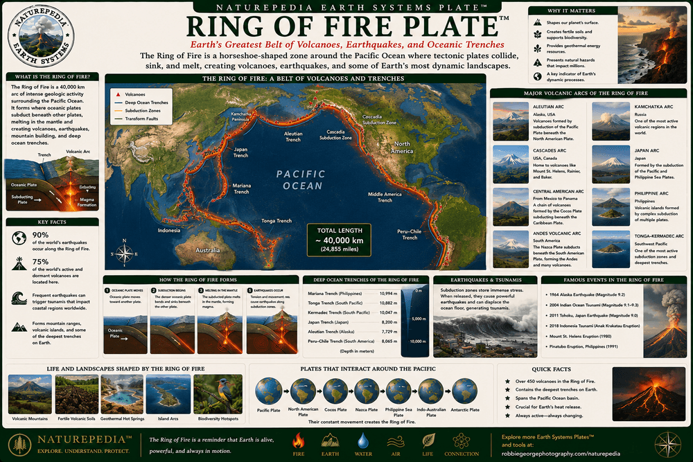
Ring of Fire Plate™

The Ring of Fire is the largest and most volcanically active region on Earth. Encircling much of the Pacific Ocean, it contains hundreds of volcanoes, frequent earthquakes, major subduction zones, and many of the geological processes responsible for shaping volcanic landscapes across the globe.

Ring of Fire Plate showing Pacific Ocean volcanic belt, subduction zones, volcanic arcs, earthquakes, tectonic boundaries, and global volcanism
Ring of Fire Plate™ — a Naturepedia™ exploration of the Pacific volcanic belt, tectonic boundaries, subduction zones, earthquakes, and global volcanic activity.

Stretching for roughly 25,000 miles (40,000 kilometers) around the Pacific Basin, the Ring of Fire contains approximately 75 percent of the world's active and dormant volcanoes. This immense geological system follows the boundaries where tectonic plates collide, slide past one another, or descend beneath neighboring plates.

Most Ring of Fire volcanoes form at subduction zones, where dense oceanic crust sinks into Earth's mantle. As descending rock melts and generates magma, volcanic mountain chains develop along continental margins and island arcs. These processes create many of the world's most famous volcanic regions, including the Andes, Cascades, Aleutians, Japan, Indonesia, New Zealand, and parts of Central America.

The Ring of Fire is also one of Earth's most seismically active regions. The same tectonic forces responsible for volcanism generate powerful earthquakes, tsunamis, mountain building, and crustal deformation. Together, these processes reveal the immense energy contained within Earth's tectonic system.

Pacific Volcanic Belt

The Ring of Fire contains the majority of Earth's active volcanoes and volcanic mountain chains.

Subduction Systems

Most Ring of Fire volcanism is driven by oceanic plates descending beneath neighboring tectonic plates.

Earthquakes & Volcanoes

Volcanic eruptions and earthquakes often occur together because both originate from tectonic plate movement.

Naturepedia Insight: The Ring of Fire is not a single volcano or mountain chain, but a planetary-scale Earth system. It represents one of the clearest examples of how tectonic forces, volcanism, earthquakes, and landscape evolution are interconnected across thousands of miles.

Visible Plate ID

ID: volcanic-landscapes#ring-of-fire-plate

URL: https://www.robbiegeorgephotography.com/volcanic-landscapes

Type: Naturepedia Earth Systems Plate™

Naturepedia Geology Plate

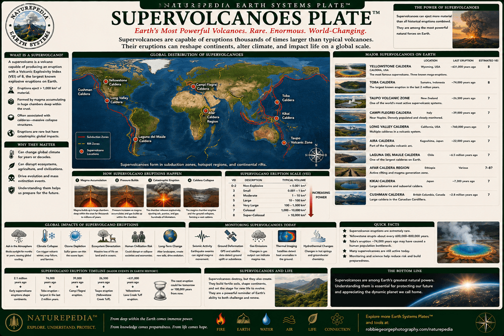
Supervolcanoes Plate™

Supervolcanoes represent the largest volcanic systems on Earth. Unlike typical volcanic mountains, these immense geological structures are capable of producing eruptions thousands of times larger than most historic volcanic events, reshaping landscapes and influencing global climate on extraordinary scales.

Supervolcanoes Plate showing Yellowstone, Toba, Taupo, giant caldera systems, magma chambers, ash deposits, and global volcanic impacts
Supervolcanoes Plate™ — a Naturepedia™ exploration of Earth's largest volcanic systems, massive calderas, giant magma chambers, and planet-scale eruption events.

The term "supervolcano" is generally used to describe volcanic systems capable of producing eruptions exceeding 1,000 cubic kilometers of erupted material. These eruptions are so large that they typically create massive calderas rather than traditional volcanic cones. The resulting landscapes may span dozens of miles across and remain geologically active for hundreds of thousands of years.

Some of Earth's most famous supervolcanoes include Yellowstone in North America, Lake Toba in Indonesia, Taupo in New Zealand, and Campi Flegrei in Italy. Each represents a vast magma system hidden beneath the surface. While these systems may appear quiet for long periods, they continue to influence geothermal activity, landscape evolution, and regional geology.

Past supervolcanic eruptions have affected global climate by injecting enormous quantities of ash and sulfur compounds into the atmosphere. These events demonstrate the powerful connection between volcanism, atmospheric systems, ecosystems, and long-term planetary change.

Yellowstone

One of Earth's best-known supervolcano systems, powering Yellowstone's geothermal features and caldera landscape.

Giant Calderas

Most supervolcanoes form vast collapse structures after major eruptions evacuate large magma chambers.

Global Effects

Large eruptions can influence climate, ecosystems, atmospheric chemistry, and environmental conditions worldwide.

Naturepedia Insight: Supervolcanoes remind us that some of Earth's most powerful geological systems are hidden beneath the surface. Their influence extends far beyond a single mountain, connecting deep magma reservoirs to climate, ecosystems, and global Earth systems.

Visible Plate ID

ID: volcanic-landscapes#supervolcanoes-plate

URL: https://www.robbiegeorgephotography.com/volcanic-landscapes

Type: Naturepedia Geology Plate™

Naturepedia Hazard Systems Plate

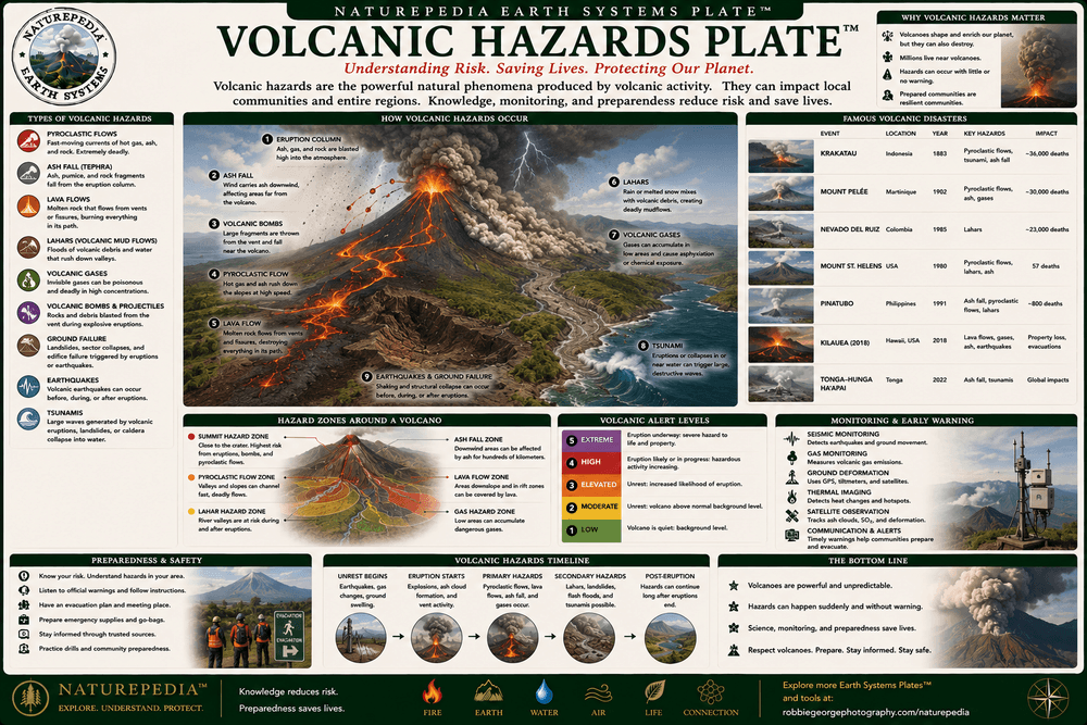
Volcanic Hazards Plate™

Volcanic hazards are the natural risks associated with eruptions, magma movement, ash production, volcanic gases, and landscape instability. While volcanoes create new land and fertile ecosystems, they can also generate some of Earth's most powerful and destructive natural events.

Volcanic Hazards Plate showing ash fall, pyroclastic flows, lahars, lava flows, volcanic gases, aviation hazards, and eruption impacts
Volcanic Hazards Plate™ — a Naturepedia™ exploration of eruption-related hazards, ash clouds, pyroclastic flows, lahars, lava, volcanic gases, and environmental impacts.

Volcanic hazards vary depending on the type of volcano, magma chemistry, eruption style, and surrounding environment. Some eruptions produce relatively slow-moving lava flows, while others generate highly explosive events capable of affecting regions hundreds or even thousands of miles away. Understanding these hazards helps scientists assess risk and improve public safety.

Among the most dangerous volcanic hazards are pyroclastic flows—fast-moving mixtures of hot gas, ash, and volcanic debris that can travel at hurricane speeds. Lahars, or volcanic mudflows, occur when water mixes with volcanic material and can devastate river valleys long after an eruption has ended. Ash fall may collapse roofs, damage crops, contaminate water supplies, and disrupt transportation networks.

Volcanic hazards also affect global systems. Ash clouds can interfere with aviation, sulfur-rich eruptions may influence climate, and large eruptions can alter ecosystems and landscapes for decades. These impacts demonstrate how volcanic activity connects local geological events with broader Earth Systems processes.

Pyroclastic Flows

Fast-moving clouds of hot gas, ash, and debris capable of traveling at extreme speeds across volcanic landscapes.

Lahars & Ash

Mudflows and ash deposits may affect communities, waterways, agriculture, and infrastructure far from the eruption site.

Global Effects

Large eruptions can influence climate, aviation, ecosystems, atmospheric chemistry, and environmental conditions worldwide.

Naturepedia Insight: Volcanic hazards reveal the dual nature of volcanism. The same forces that create islands, fertile soils, ecosystems, and spectacular landscapes can also produce some of the most powerful natural disturbances on Earth.

Visible Plate ID

ID: volcanic-landscapes#volcanic-hazards-plate

URL: https://www.robbiegeorgephotography.com/volcanic-landscapes

Type: Naturepedia Hazard Systems Plate™

Naturepedia Photography Plate

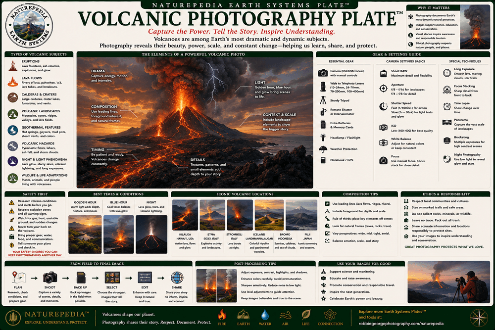
Volcanic Photography Plate™

Volcanic photography captures some of Earth's most dramatic geological events and landscapes. From glowing lava rivers and erupting volcanoes to calderas, ash clouds, lava fields, and geothermal regions, these scenes reveal the raw power of planetary processes in action.

Volcanic Photography Plate showing erupting volcanoes, lava flows, calderas, volcanic landscapes, night photography, and field techniques
Volcanic Photography Plate™ — a Naturepedia™ guide to photographing volcanic landscapes, lava flows, eruptions, geothermal features, and dynamic Earth systems.

Photographing volcanoes presents unique opportunities and challenges. Volcanic landscapes often contain extreme contrasts between glowing lava, dark terrain, steam, ash, snow, ice, and changing weather. These environments require photographers to balance technical skill with an understanding of geological processes and field safety.

Some of the most iconic volcanic photographs feature active eruptions, lava fountains, flowing basalt, volcanic lightning, crater lakes, and dramatic caldera landscapes. Others focus on quieter scenes where volcanic geology interacts with ecosystems, weather, glaciers, forests, and wildlife. Together, these images help people visualize Earth's ongoing transformation.

Volcanic photography also serves an educational role. Images document eruptions, monitor geological change, support scientific research, and provide visual records of landscapes that may evolve dramatically over time. In many cases, photographs become part of the historical record of volcanic activity itself.

Eruptions & Lava

Active eruptions provide opportunities to document some of the most dynamic geological events occurring on Earth.

Volcanic Landscapes

Calderas, lava fields, volcanic islands, crater lakes, and geothermal regions create extraordinary landscape photography subjects.

Field Safety

Successful volcanic photography requires awareness of terrain, gases, unstable ground, weather conditions, and eruption hazards.

Naturepedia Insight: Volcanic photography allows us to witness Earth creating new landscapes in real time. Few subjects reveal the scale, energy, beauty, and power of geological processes as dramatically as volcanoes and the worlds they build.

Visible Plate ID

ID: volcanic-landscapes#volcanic-photography-plate

URL: https://www.robbiegeorgephotography.com/volcanic-landscapes

Type: Naturepedia Photography Plate™

Naturepedia Planetary Geology Plate

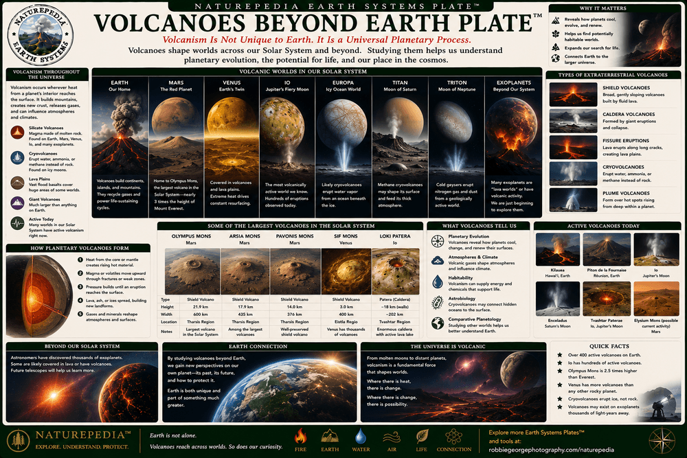
Volcanoes Beyond Earth Plate™

Volcanoes are not unique to Earth. Across the Solar System, volcanic processes have shaped planets, moons, and icy worlds through eruptions of rock, sulfur, ice, and other materials. These extraterrestrial volcanoes reveal how planetary geology operates beyond our home planet.

Volcanoes Beyond Earth Plate showing Olympus Mons, Mars volcanoes, Venus volcanoes, Io volcanism, cryovolcanoes, and planetary geology
Volcanoes Beyond Earth Plate™ — a Naturepedia™ exploration of planetary volcanism, giant shield volcanoes, cryovolcanoes, and geological processes throughout the Solar System.

Mars hosts the largest volcano known in the Solar System: Olympus Mons. Rising approximately 72,000 feet (22 kilometers) above the surrounding terrain, this enormous shield volcano dwarfs any volcanic mountain on Earth. Its immense size was made possible by Mars' lower gravity and lack of moving tectonic plates.

Jupiter's moon Io is the most volcanically active body in the Solar System. Gravitational interactions with Jupiter generate intense internal heating that powers hundreds of active volcanoes. Some eruptions on Io launch material hundreds of miles above the surface, creating spectacular sulfur-rich plumes visible from space.

Not all extraterrestrial volcanism involves molten rock. On icy worlds such as Enceladus, Europa, Triton, and Pluto, scientists have identified evidence for cryovolcanism, where water, ammonia, methane, or other volatile substances erupt instead of lava. These processes expand our understanding of how planetary geology can operate under very different conditions.

Olympus Mons

The largest volcano in the Solar System, located on Mars and towering far above any volcano on Earth.

Io

Jupiter's moon contains hundreds of active volcanoes fueled by intense tidal heating from gravitational forces.

Cryovolcanoes

Some icy worlds erupt water, ammonia, methane, or other frozen materials instead of molten rock.

Naturepedia Insight: Volcanoes are a planetary phenomenon, not just an Earth process. From lava giants on Mars to sulfur eruptions on Io and cryovolcanoes on icy moons, volcanism reveals how worlds release internal energy and continually reshape their surfaces across the Solar System.

Visible Plate ID

ID: volcanic-landscapes#volcanoes-beyond-earth-plate

URL: https://www.robbiegeorgephotography.com/volcanic-landscapes

Type: Naturepedia Planetary Geology Plate™

About the Author

Robbie George

Robbie George is a nature photographer, ecological educator, and creator of the Naturepedia™ knowledge system. His work combines wildlife photography, geology, biodiversity, ecosystem science, natural history, and environmental storytelling to help people better understand the interconnected processes that shape our planet.

Through Naturepedia™, Robbie is building a structured educational framework that connects species, habitats, ecosystems, geology, hydrology, biodiversity, Earth Systems science, and planetary processes into one accessible knowledge platform. The project combines scientific interpretation, field experience, visual learning, and landscape photography to reveal relationships that often remain hidden within nature.

Volcanic Landscapes™ occupies a pivotal position within Naturepedia because volcanoes connect many of Earth's most important systems. Volcanism links plate tectonics, geothermal activity, hydrothermal ecosystems, biodiversity, ecological succession, climate processes, planetary geology, and the ongoing creation of new landscapes. Few natural forces demonstrate the interconnectedness of Earth Systems more clearly than volcanism.

Robbie’s photography has been featured by major publications and institutions, including the Smithsonian National Museum of Natural History. His work focuses on helping people see ecological relationships, geological processes, wildlife behavior, biodiversity patterns, and environmental systems through both photography and education.

The hero image featured on this page was photographed inside a volcanic caldera in Iceland. Landscapes such as these illustrate how volcanic activity shapes terrain, influences ecosystems, and creates some of the most visually striking environments on Earth. They also provide a direct connection to many of the geological processes explored throughout Naturepedia.

Through the ongoing development of Naturepedia™, Robbie continues building a growing knowledge mesh connecting Yellowstone Thermal Features™, Geothermal Ecosystems™, Microbial Life Systems™, Hydrothermal Ecosystems™, Volcanic Landscapes™, and future Earth Systems™ layers into a unified educational framework that explores life from Earth's deep interior to the broader cosmos.


Frequently Asked Questions

Volcanic Landscapes™ FAQ

What are volcanic landscapes?

Volcanic landscapes are regions shaped by magma, lava, ash, volcanic gases, calderas, craters, plate tectonics, erosion, water, ice, and time. They include volcanoes, lava fields, volcanic islands, geothermal regions, and volcanic soils.

How do volcanoes create new land?

Volcanoes create new land when lava, ash, and volcanic debris accumulate at the surface. Over time, repeated eruptions can build mountains, islands, lava plains, coastlines, and entire volcanic regions.

What is a caldera?

A caldera is a large volcanic basin formed when a magma chamber empties during a major eruption and the ground above collapses inward. Calderas may later contain lakes, geothermal systems, domes, forests, or renewed volcanic activity.

What is the difference between magma and lava?

Magma is molten rock beneath Earth's surface. Lava is magma that has erupted onto the surface. Once lava cools, it becomes solid volcanic rock.

Why are volcanic soils fertile?

Volcanic soils can be fertile because weathered lava and ash release minerals such as potassium, phosphorus, calcium, magnesium, iron, and trace elements. Over time, microbes, water, plants, and organic matter help turn volcanic rock into living soil.

How does life return after a volcanic eruption?

Life returns through ecological succession. Microbes, fungi, lichens, and mosses colonize bare rock first. These pioneer organisms help form soil, allowing grasses, shrubs, trees, insects, wildlife, and mature ecosystems to develop over time.

What is the Ring of Fire?

The Ring of Fire is a major volcanic and earthquake zone surrounding much of the Pacific Ocean. It contains many of the world's active volcanoes and is shaped largely by tectonic plate boundaries and subduction zones.

What are supervolcanoes?

Supervolcanoes are very large volcanic systems capable of producing extremely large eruptions. They often form massive calderas and can influence landscapes, ecosystems, and climate across broad regions.

Are there volcanoes beyond Earth?

Yes. Volcanoes and volcanic processes occur on other worlds, including Mars, Venus, Io, and icy moons. Some bodies have rock volcanism, while others may have cryovolcanoes that erupt water, ice, ammonia, methane, or other volatile materials.

Why are volcanic landscapes important to Earth Systems science?

Volcanic landscapes connect geology, plate tectonics, climate, water systems, geothermal activity, hydrothermal ecosystems, biodiversity, soil formation, hazards, and planetary geology. They show how Earth's internal energy shapes the surface and supports long-term ecological change.

Trusted Art Seller

Trusted Art Seller

The presence of this badge signifies that this business has officially registered with the Art Storefronts Organization and has an established track record of selling art.

It also means that buyers can trust that they are buying from a legitimate business. Art sellers that conduct fraudulent activity or that receive numerous complaints from buyers will have this badge revoked. If you would like to file a complaint about this seller, please do so here.

Verified Returns & Exchanges

Verified Returns & Exchanges

The Art Storefronts Organization has verified that this business has provided a returns & exchanges policy for all art purchases.

Description of Policy from Merchant:

What is your Policy on Returns/Exchanges/Refunds? I take great pride in my work and prints, and I want you to be completely happy with your investment in my nature art. If for any reason you are unsatisfied with your print, you may return it within 14 days of delivery, and/or exchange it for another print. Prints must be returned in new condition, packaged carefully in the original packaging if possible. Your refund will be issued as soon as I receive the returned print. Please contact me if you would like to arrange a return or exchange. In the event that you receive a damaged or defective print, please let me know within 7 days of receipt, and I will arrange for a new print to be shipped to you at no additional cost.

Verified Secure Website with Safe Checkout

Verified Secure Website with Safe Checkout

This website provides a secure checkout with SSL encryption.

Verified Archival Materials Used

Verified Archival Materials Used

The Art Storefronts Organization has verified that this Art Seller has published information about the archival materials used to create their products in an effort to provide transparency to buyers.

Description from Merchant:

Fine Art Prints are made with high-quality archival inks on fine art papers using a high-resolution large format inkjet printer. Our premium archival inks produce images with smooth tones and rich colors. Prints are made with care on your choice of exquisite Fine Art Papers using a high-resolution large format inkjet printer. https://www.graphikprintworks.com

Cart

Your cart is currently empty.

Saved Successfully.

This is only visible to you because you are logged in and are authorized to manage this website. This message is not visible to other website visitors.

Import From Instagram

Click on any Image to continue

This Website Supports Augmented Reality to Live Preview Art

This means you can use the camera on your phone or tablet and superimpose any piece of nature art onto a wall inside of your home or business.

To use this feature, Just look for the "Live Preview AR" button when viewing any piece of nature art on this website!

🦊 Pounce now for 20% off

No thanks