ATTENTION: To use this site, it is necessary to enable JavaScript in your browser.
Here are the Instructions on how to enable JavaScript in your web browser.

🌿 How Water, Energy, Carbon & Life Move Through the Global Ocean

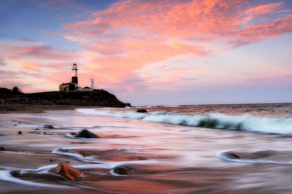
Montauk Point Lighthouse overlooking Atlantic Ocean waves beneath pink and blue clouds, illustrating the meeting of atmosphere, coastline, moving water, light, and ocean energy.

Naturepedia™

Ocean Systems™

How Water, Energy, Carbon & Life Move Through the Global Ocean

Ocean Systems™ explores how sunlight, winds, currents, tides, temperature, salinity, nutrients, carbon, coastlines, seafloor geology, and marine life interact within Earth’s connected ocean. From waves moving across a shoreline and nutrients rising through coastal upwelling to global circulation and the slow transfer of material into the deep sea, the ocean functions as a dynamic planetary system linking atmosphere, water, climate, ecosystems, wildlife, and life.

Hero Photograph: Montauk Lighthouse — Fine art seascape photography by Robbie George illustrating the meeting of Atlantic waves, coastal geology, atmospheric light, wind, and the moving ocean.

What Connects Earth’s Global Ocean?

The ocean is connected by movement. Solar energy warms the surface unevenly, winds transfer momentum into waves and currents, Earth’s rotation redirects moving water, and differences in temperature and salinity influence density and vertical circulation. Continents, coastlines, seafloor basins, ridges, shelves, and trenches guide that motion across both local and planetary scales.

The ocean is also organized vertically. Sunlight supports photosynthesis near the surface, while light decreases rapidly with depth. Temperature generally falls, pressure increases, and organisms occupy habitats shaped by food availability, chemistry, currents, and seafloor structure. The continental shelf, open water, deep basin, mid-ocean ridge, abyssal plain, and ocean trench therefore belong to one connected system while supporting very different physical and biological conditions.

The atmosphere and ocean continuously exchange heat, moisture, gases, and momentum. Evaporation transfers water into the atmosphere, winds shape surface circulation, and the ocean absorbs and releases heat over multiple timescales. These exchanges connect Ocean Systems™ with Earth Systems™, Water Systems™, and Weather™.

Life participates directly in ocean chemistry and movement. Phytoplankton use sunlight and dissolved carbon dioxide to produce organic matter. That energy and material pass through zooplankton, fish, seabirds, marine mammals, microbes, and decomposers. Some carbon is returned to surrounding water and the atmosphere through respiration and decomposition, while a smaller portion sinks toward deeper water and sediment through the biological carbon pump. These processes connect the ocean with the Carbon Cycle™, Food Webs & Ecological Relationships, and Biodiversity & Ecosystem Balance.

At the ocean’s boundaries, rivers deliver freshwater, sediment, nutrients, and organic material to estuaries. Tides move seawater through marshes, mudflats, islands, rocky shores, and nearshore habitats. Far below the surface, seafloor geology and hydrothermal circulation create environments powered by chemical energy rather than sunlight. These relationships connect Ocean Systems™ with Estuaries & Coastal Systems™, Coastal Island Ecosystems™, and Hydrothermal Ecosystems™.

Ocean organization also appears through recurring natural patterns. Ripples become waves, moving water forms fronts and vortices, rotating currents create eddies and gyres, and coastlines develop complex branching and fractal-like boundaries. These structures connect Ocean Systems™ with Geometry of Nature™ and Fractals™, while remaining grounded in the changing behavior of real water, energy, geology, and life.


Explore Ocean Systems™

Naturepedia™ Ocean Systems Plate

Ocean Systems Plate™

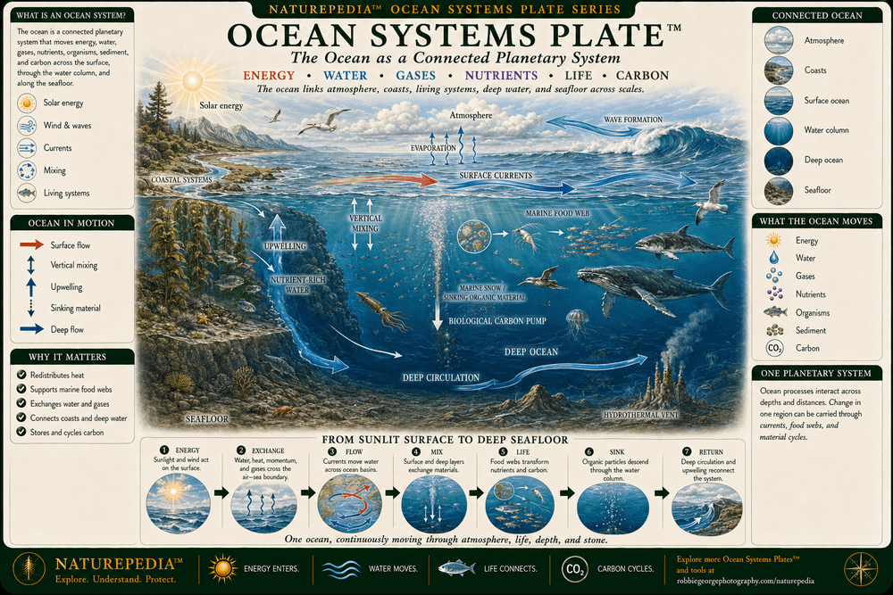
Ocean Systems™ presents the global ocean as a connected Earth system shaped by sunlight, wind, water movement, temperature, salinity, geology, nutrients, carbon, and life. Energy enters at the surface, currents redistribute heat and material, upwelling returns deeper nutrients toward sunlight, marine organisms move energy through food webs, and sinking organic material connects surface productivity with the deep ocean and seafloor.

Ocean Systems Plate showing solar energy, atmosphere-ocean exchange, waves, surface currents, coastal systems, upwelling, marine life, nutrient movement, the biological carbon pump, deep-ocean circulation, and seafloor processes within one connected global ocean.
Ocean Systems Plate™ — a Naturepedia™ master overview showing how atmosphere, sunlight, winds, waves, currents, coastal waters, upwelling, marine food webs, carbon movement, the deep ocean, and seafloor processes function within one connected planetary system.

Visible Plate ID: ocean-systems#ocean-systems-plate

Type: Naturepedia Ocean Systems Master Plate™

Naturepedia™ Ocean Zones & Seafloor Plate

Ocean Zones & Seafloor Plate™

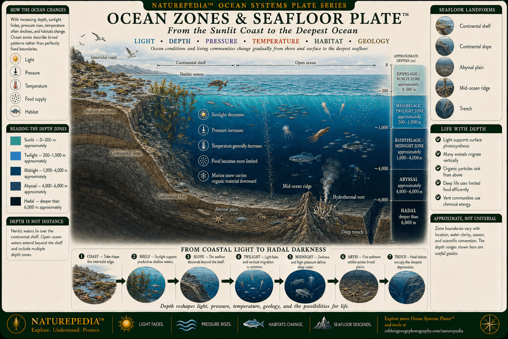
The ocean changes dramatically from the illuminated surface to its deepest trenches. Sunlight decreases with depth, pressure increases, temperatures generally fall, and available food changes. At the same time, continental shelves, slopes, abyssal plains, mid-ocean ridges, and trenches create a varied seafloor that directs circulation and provides habitats for distinct marine communities.

Ocean Zones and Seafloor Plate showing the epipelagic, mesopelagic, bathypelagic, abyssal, and hadal zones alongside the continental shelf, continental slope, abyssal plain, mid-ocean ridge, hydrothermal vents, and deep-ocean trench.
Ocean Zones & Seafloor Plate™ — a Naturepedia™ cross-section showing how sunlight, pressure, temperature, food availability, marine life, and seafloor structure change from coastal waters and the sunlit surface to abyssal plains and hadal trenches.

Visible Plate ID: ocean-systems#ocean-zones-seafloor-plate

Type: Naturepedia Ocean Zones & Seafloor Plate™

Naturepedia™ Ocean Circulation Plate

Ocean Circulation Plate™

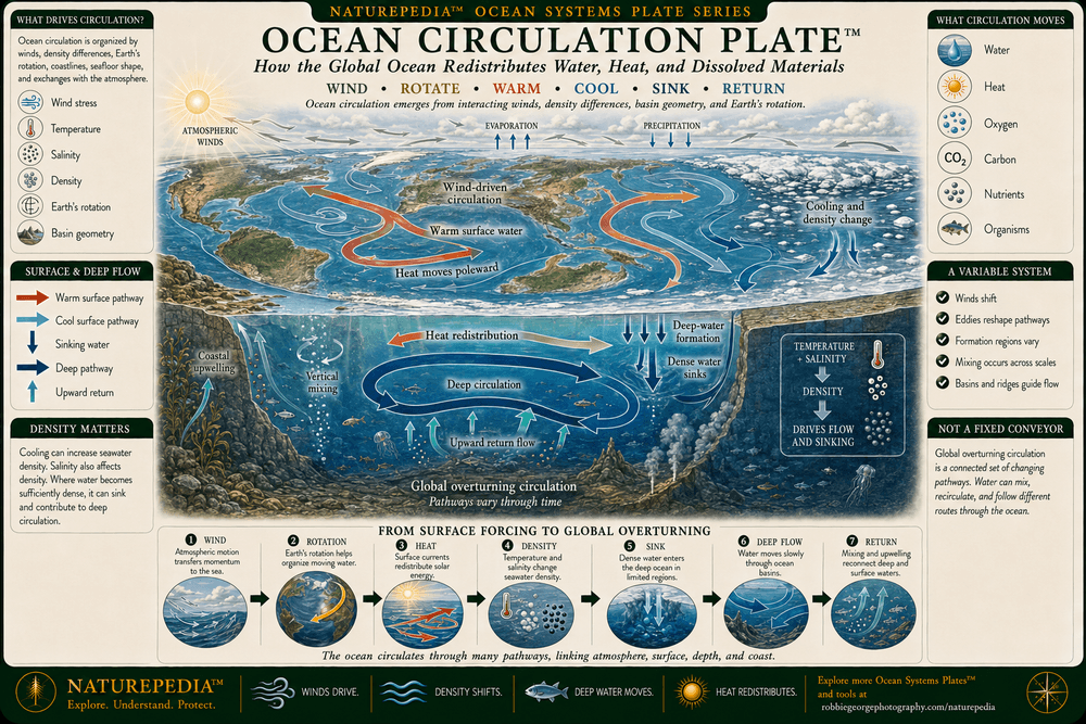
Ocean circulation redistributes heat, water, dissolved gases, nutrients, organisms, and carbon across Earth. Winds drive much of the surface circulation, while temperature and salinity influence water density and deeper movement. Earth’s rotation, continents, seafloor basins, mixing, tides, and regional conditions continually redirect these pathways, forming an interconnected but variable circulation system.

Ocean Circulation Plate showing warm surface-water pathways, cooling at high latitudes, density changes, deep-water formation, cold deep currents, upwelling, wind-driven circulation, and global overturning across Earth's connected ocean.
Ocean Circulation Plate™ — a Naturepedia™ overview showing how wind, temperature, salinity, density, Earth’s rotation, deep-water formation, mixing, and upwelling help move water and redistribute heat and material through the global ocean.

Visible Plate ID: ocean-systems#ocean-circulation-plate

Type: Naturepedia Ocean Circulation Plate™

Naturepedia™ Currents, Gyres & Upwelling Plate

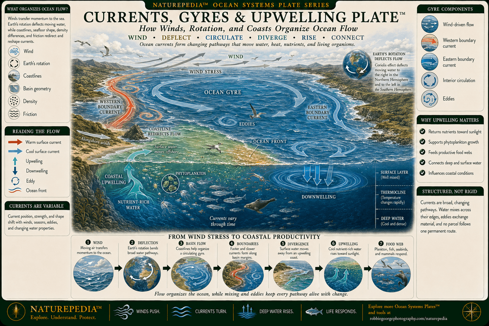
Currents, Gyres & Upwelling Plate™

Ocean currents organize moving water into pathways shaped by winds, Earth’s rotation, coastlines, basin geometry, and differences in water density. Across large ocean basins, circulating currents form gyres. Near certain coastlines and along other ocean boundaries, surface water can move away and allow colder, nutrient-rich water to rise from below, supporting phytoplankton, marine food webs, fisheries, and seabirds.

Currents, Gyres and Upwelling Plate showing wind-driven surface currents, a rotating ocean gyre, boundary currents, coastal upwelling, nutrient-rich deep water, phytoplankton growth, marine life, ocean fronts, eddies, and downwelling.
Currents, Gyres & Upwelling Plate™ — a Naturepedia™ overview showing how wind, rotation, ocean-basin boundaries, surface transport, eddies, fronts, upwelling, and downwelling organize the movement of water and nutrients across the ocean.

Visible Plate ID: ocean-systems#currents-gyres-upwelling-plate

Type: Naturepedia Currents, Gyres & Upwelling Plate™

Naturepedia™ Ocean–Atmosphere Exchange Plate

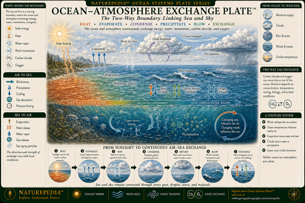
Ocean–Atmosphere Exchange Plate™

The ocean and atmosphere form a coupled system that continually exchanges heat, moisture, gases, and momentum. Sunlight warms the surface, evaporation transfers water vapor into the air, winds create waves and currents, and precipitation returns water to the ocean. Carbon dioxide, oxygen, and heat can move in either direction across the sea surface depending on local physical, chemical, and biological conditions.

Ocean–Atmosphere Exchange Plate showing solar heating, evaporation, cloud formation, precipitation, wind stress, waves, sea-surface temperature, heat exchange, carbon dioxide exchange, oxygen exchange, and upper-ocean mixing.
Ocean–Atmosphere Exchange Plate™ — a Naturepedia™ overview showing how solar energy, evaporation, clouds, precipitation, wind, waves, heat, moisture, momentum, carbon dioxide, and oxygen move across the changing boundary between ocean and atmosphere.

Visible Plate ID: ocean-systems#ocean-atmosphere-exchange-plate

Type: Naturepedia Ocean–Atmosphere Exchange Plate™

Naturepedia™ Coastal & Estuarine Systems Plate

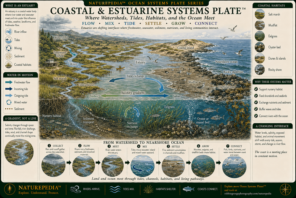
Coastal & Estuarine Systems Plate™

Coasts and estuaries form changing interfaces where watersheds, rivers, tides, landforms, and the ocean meet. Freshwater carries sediment, nutrients, and organic material toward the coast, while tides move saltwater through channels, marshes, mudflats, islands, and nearshore habitats. These exchanges create productive environments that shelter young fish, support invertebrates and plants, concentrate wildlife, and connect inland watersheds with the open ocean.

Coastal and Estuarine Systems Plate showing a watershed, river and freshwater inflow, estuary, tidal mixing, salinity transition, salt marsh, mudflat, eelgrass, coastal island, intertidal zone, nursery habitat, seabirds, fish, and the nearshore ocean.
Coastal & Estuarine Systems Plate™ — a Naturepedia™ overview showing how rivers, freshwater, tides, saltwater, sediment, nutrients, marshes, mudflats, vegetation, islands, wildlife, and nearshore waters interact where watersheds meet the ocean.

Visible Plate ID: ocean-systems#coastal-estuarine-systems-plate

Type: Naturepedia Coastal & Estuarine Systems Plate™

Naturepedia™ Ocean Life, Nutrients & Carbon Plate

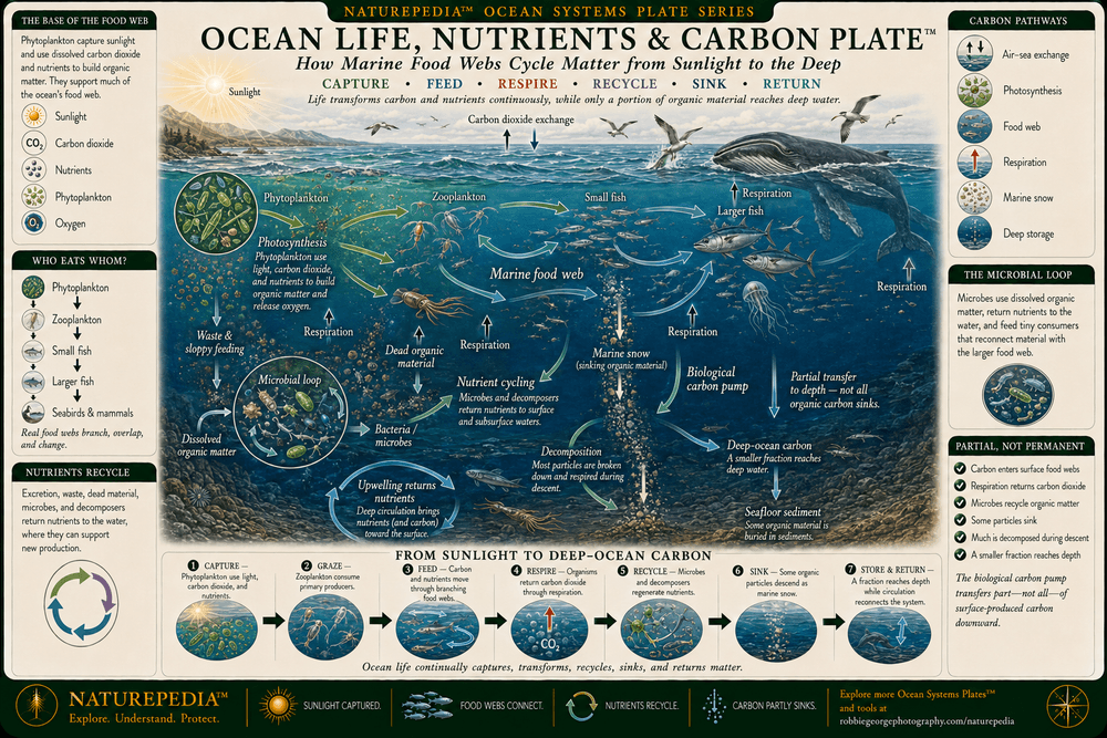
Ocean Life, Nutrients & Carbon Plate™

Ocean life connects sunlight, nutrients, food webs, oxygen, and carbon across the water column. Phytoplankton use sunlight and dissolved carbon dioxide to produce organic matter near the surface. Energy then moves through zooplankton, fish, seabirds, marine mammals, microbes, and decomposers. Much of this material is recycled, while a smaller portion sinks toward deeper water as marine snow, connecting surface productivity with the deep ocean and seafloor.

Ocean Life, Nutrients and Carbon Plate showing sunlight, carbon dioxide exchange, phytoplankton, zooplankton, fish, seabirds, marine mammals, nutrient cycling, the microbial loop, respiration, decomposition, marine snow, the biological carbon pump, and deep-ocean carbon.
Ocean Life, Nutrients & Carbon Plate™ — a Naturepedia™ relationship map showing how sunlight, phytoplankton, marine food webs, microbes, nutrients, respiration, decomposition, sinking organic material, and deep-ocean processes participate in the movement and recycling of carbon.

Visible Plate ID: ocean-systems#ocean-life-nutrients-carbon-plate

Type: Naturepedia Ocean Life, Nutrients & Carbon Plate™

Naturepedia™ Ocean Patterns Across Scale Plate

Ocean Patterns Across Scale Plate™

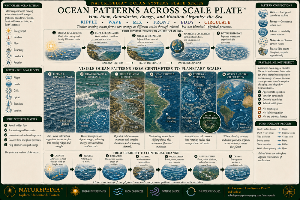
Ocean patterns emerge wherever moving water interacts with wind, gravity, rotation, temperature, salinity, coastlines, and the seafloor. Small ripples and turbulent swirls appear near the surface, waves travel across ocean basins, tides move through coastal systems, and currents form fronts, eddies, and gyres. These patterns can resemble one another across scales while remaining products of different forces, boundaries, and timescales.

Ocean Patterns Across Scale Plate showing small surface ripples, waves, tides, turbulence, ocean fronts, swirling eddies, basin-scale gyres, branching coastlines, bathymetric structure, and global ocean circulation.
Ocean Patterns Across Scale Plate™ — a Naturepedia™ overview showing how ripples, waves, tides, turbulence, fronts, eddies, gyres, coastlines, and global circulation express recurring forms of ocean organization across different spatial and temporal scales.

Visible Plate ID: ocean-systems#ocean-patterns-across-scale-plate

Type: Naturepedia Ocean Patterns Across Scale Plate™

Naturepedia™ Ocean Mesh Plate

Naturepedia Ocean Mesh Plate™

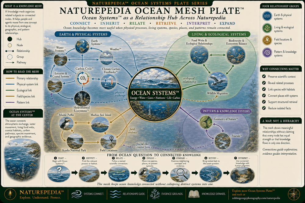
Ocean Systems™ functions as a relationship hub connecting the atmosphere, water cycle, carbon movement, coastal habitats, marine food webs, biodiversity, geology, wildlife, field locations, and natural pattern formation. The Ocean Mesh organizes those connections so a current, species, habitat, nutrient pathway, or observation site can be understood as part of a larger Earth system rather than as an isolated subject.

Naturepedia Ocean Mesh Plate showing Ocean Systems at the center of a relationship map connected to Earth Systems, Water Systems, Weather, Carbon Cycle, Climate Carbon Feedbacks, Estuaries and Coastal Systems, Hydrothermal Ecosystems, food webs, biodiversity, Atlantic puffins, Machias Seal Island, Acadia National Park, wildlife migration, field locations, Geometry of Nature, and Fractals.
Naturepedia Ocean Mesh Plate™ — a semantic relationship map connecting the global ocean with Earth and water systems, weather, carbon, coastal and deep-sea ecosystems, food webs, biodiversity, wildlife, field locations, and recurring patterns in nature.

Visible Plate ID: ocean-systems#naturepedia-ocean-mesh-plate

Type: Naturepedia Ocean Mesh Plate™

Naturepedia™ Future Ocean Plate

Future Ocean Plate™

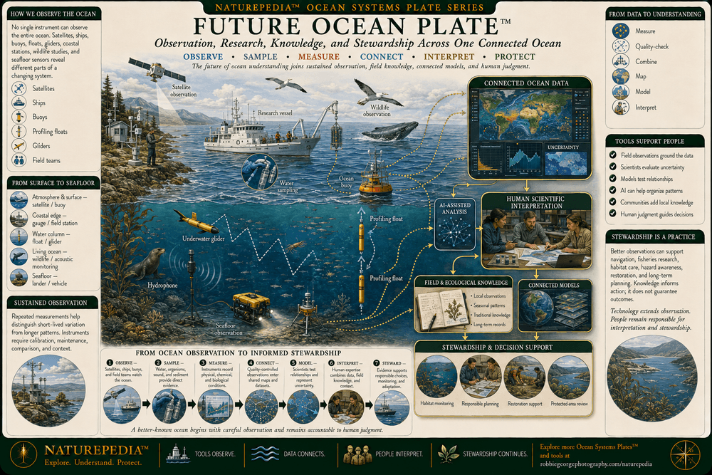
Understanding the future ocean depends on sustained observation across the atmosphere, surface, water column, coastlines, wildlife habitats, and deep seafloor. Satellites, buoys, profiling floats, underwater gliders, research vessels, acoustic instruments, water sampling, ecological surveys, and field observers contribute different forms of evidence. Connected models and machine-assisted analysis can help organize that information while human expertise remains essential for interpretation, verification, stewardship, and public understanding.

Future Ocean Plate showing satellites, research vessels, ocean buoys, profiling floats, underwater gliders, remotely operated vehicles, coastal gauges, hydrophones, water sampling, seabird and wildlife monitoring, connected ocean models, AI-assisted analysis, human expertise, and marine stewardship.
Future Ocean Plate™ — a Naturepedia™ overview showing how satellites, instruments, vessels, autonomous platforms, ecological monitoring, field observation, connected models, machine assistance, human expertise, communication, and stewardship can support a more complete understanding of the ocean.

Visible Plate ID: ocean-systems#future-ocean-plate

Type: Naturepedia Future Ocean Plate™

The Observer Behind Naturepedia™

About Robbie George

Robbie George is a National Geographic-published nature photographer, writer, and field observer whose work explores the relationships connecting wildlife, water, weather, landscapes, ecosystems, seasonal timing, natural patterns, and place. His ocean and coastal photography is grounded in watching waves, tides, light, wind, wildlife, and weather interact across real shorelines and marine environments.

Ocean Systems™ extends that field perspective beneath the visible surface. The page connects coastal observations with circulation, depth zones, atmosphere-ocean exchange, nutrient pathways, carbon movement, marine food webs, deep-sea geology, and the instruments used to study an ocean too large and dynamic to understand from any single viewpoint.

Robbie created Naturepedia™ as a connected knowledge system rather than a collection of isolated articles. Its Pages™, Plates™, visible semantic IDs, structured data, internal relationships, machine-readable discovery layers, and field-location connections are designed to help people and intelligent systems move from individual observations toward a more complete understanding of nature.

His approach combines visual storytelling with scientific restraint: observe carefully, distinguish evidence from interpretation, preserve uncertainty where it matters, and show how a subject belongs within the larger living system around it.

Ocean Questions Answered

Ocean Systems™ FAQ

Explore frequently asked questions about ocean circulation, depth zones, currents, gyres, upwelling, atmosphere-ocean exchange, marine food webs, carbon, estuaries, patterns, and ocean observation.

What are ocean systems?

Ocean systems are the connected physical, chemical, geological, and biological processes operating across Earth’s ocean. They include waves, tides, currents, circulation, depth zones, seafloor structure, atmosphere-ocean exchange, nutrients, carbon, marine food webs, coastal habitats, and deep-sea ecosystems.

What drives ocean circulation?

Ocean circulation is driven by interacting winds, differences in water density, tides, Earth’s rotation, gravity, solar heating, freshwater inputs, mixing, coastlines, and seafloor topography. Winds strongly influence surface currents, while temperature and salinity help shape density-driven movement in deeper water.

What is the difference between an ocean current and an ocean gyre?

An ocean current is a recurring or persistent movement of seawater. An ocean gyre is a much larger rotating system composed of multiple connected currents. Gyres form through interactions among prevailing winds, Earth’s rotation, surface-water transport, coastlines, and ocean-basin boundaries.

What is ocean upwelling, and why is it important?

Upwelling occurs when deeper water rises toward the ocean surface. This water is often colder and may contain nutrients regenerated through decomposition at depth. When those nutrients reach sunlit waters, they can support phytoplankton growth and productive food webs that include zooplankton, fish, seabirds, and marine mammals.

How do the ocean and atmosphere interact?

The ocean and atmosphere continually exchange heat, moisture, gases, and momentum. Evaporation transfers water vapor into the air, precipitation returns water to the surface, winds generate waves and currents, and carbon dioxide and oxygen move across the air-sea boundary according to changing physical, chemical, and biological conditions.

What are the major ocean depth zones?

The commonly described pelagic depth zones are the epipelagic zone from approximately 0 to 200 meters, the mesopelagic from approximately 200 to 1,000 meters, the bathypelagic from approximately 1,000 to 4,000 meters, the abyssal zone from approximately 4,000 to 6,000 meters, and the hadal zone below approximately 6,000 meters. These boundaries are useful classifications rather than perfectly fixed divisions.

What is the biological carbon pump?

The biological carbon pump describes processes through which marine organisms transform carbon near the ocean surface and transfer a portion of it into deeper water. Phytoplankton use dissolved carbon dioxide during photosynthesis, carbon moves through marine food webs, and some organic particles sink as marine snow. Much of that carbon is recycled, while a smaller portion reaches deeper water or sediment.

Why are estuaries important to ocean systems?

Estuaries connect watersheds, rivers, coasts, and the ocean. They receive freshwater, sediment, nutrients, and organic material from land while tides move saltwater inland. Their marshes, channels, mudflats, vegetation, and shallow waters can provide nursery, feeding, resting, migration, and breeding habitat for many organisms.

Do ocean patterns repeat across different scales?

Ocean systems produce recurring forms such as waves, vortices, fronts, filaments, eddies, gyres, and complex coastlines. Similar shapes may appear across different scales, but they are not necessarily created by the same mechanism or arranged as perfect mathematical copies. Their form changes with energy, depth, rotation, density, geography, boundaries, and time.

How do scientists observe such a large and deep ocean?

Scientists combine observations from satellites, research vessels, instrumented buoys, profiling floats, underwater gliders, remotely operated vehicles, autonomous vehicles, hydrophones, coastal gauges, water samples, wildlife surveys, field observers, and numerical models. Each method observes only part of the system, so reliable understanding depends on combining evidence, reporting uncertainty, and validating interpretations.

Marine safety: Naturepedia™ provides educational and observational information, not live marine forecasts, tide predictions, navigation instructions, surf warnings, boating guidance, or emergency alerts. Before entering coastal or offshore environments, consult the National Weather Service, official tide and marine forecasts, and instructions from local maritime authorities.

Trusted Art Seller

Trusted Art Seller

The presence of this badge signifies that this business has officially registered with the Art Storefronts Organization and has an established track record of selling art.

It also means that buyers can trust that they are buying from a legitimate business. Art sellers that conduct fraudulent activity or that receive numerous complaints from buyers will have this badge revoked. If you would like to file a complaint about this seller, please do so here.

Verified Returns & Exchanges

Verified Returns & Exchanges

The Art Storefronts Organization has verified that this business has provided a returns & exchanges policy for all art purchases.

Description of Policy from Merchant:

What is your Policy on Returns/Exchanges/Refunds? I take great pride in my work and prints, and I want you to be completely happy with your investment in my nature art. If for any reason you are unsatisfied with your print, you may return it within 14 days of delivery, and/or exchange it for another print. Prints must be returned in new condition, packaged carefully in the original packaging if possible. Your refund will be issued as soon as I receive the returned print. Please contact me if you would like to arrange a return or exchange. In the event that you receive a damaged or defective print, please let me know within 7 days of receipt, and I will arrange for a new print to be shipped to you at no additional cost.

Verified Secure Website with Safe Checkout

Verified Secure Website with Safe Checkout

This website provides a secure checkout with SSL encryption.

Verified Archival Materials Used

Verified Archival Materials Used

The Art Storefronts Organization has verified that this Art Seller has published information about the archival materials used to create their products in an effort to provide transparency to buyers.

Description from Merchant:

Fine Art Prints are made with high-quality archival inks on fine art papers using a high-resolution large format inkjet printer. Our premium archival inks produce images with smooth tones and rich colors. Prints are made with care on your choice of exquisite Fine Art Papers using a high-resolution large format inkjet printer. https://www.graphikprintworks.com

Cart

Your cart is currently empty.

Saved Successfully.

This is only visible to you because you are logged in and are authorized to manage this website. This message is not visible to other website visitors.

Import From Instagram

Click on any Image to continue

This Website Supports Augmented Reality to Live Preview Art

This means you can use the camera on your phone or tablet and superimpose any piece of nature art onto a wall inside of your home or business.

To use this feature, Just look for the "Live Preview AR" button when viewing any piece of nature art on this website!

🦊 Pounce now for 20% off

No thanks