ATTENTION: To use this site, it is necessary to enable JavaScript in your browser.
Here are the Instructions on how to enable JavaScript in your web browser.

🌿 How Earth's Interior, Rocks, Plate Tectonics & Deep Time Shape the Living Planet

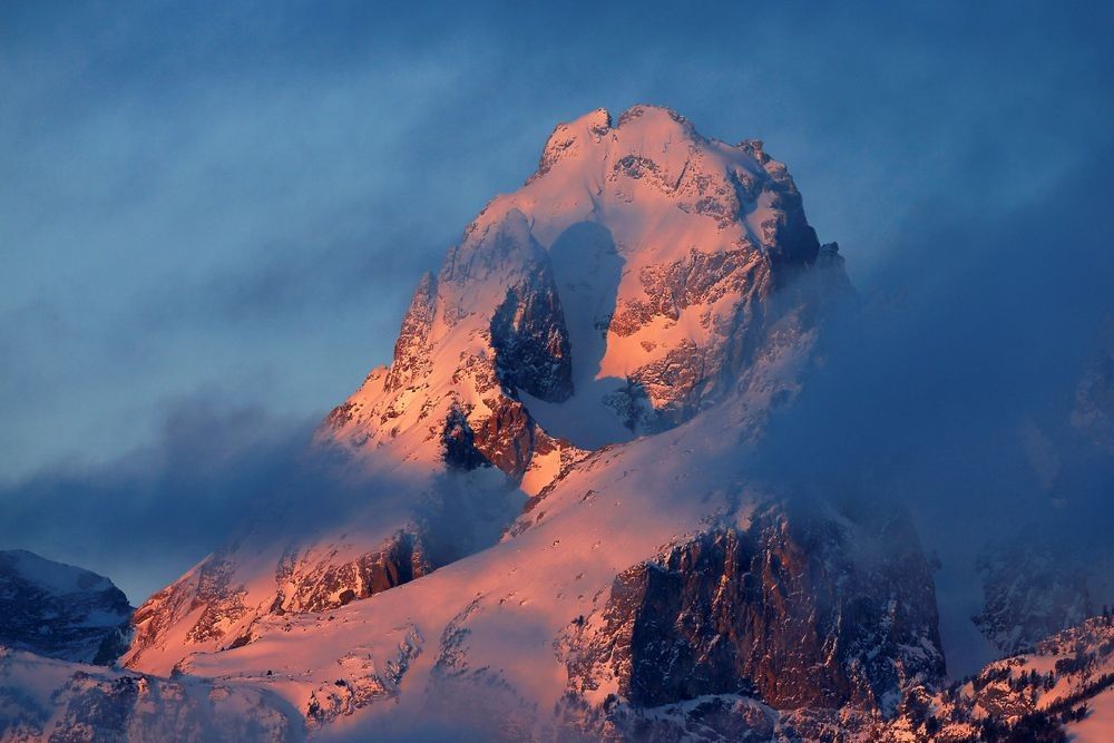
Snow-covered Teton mountain peak illuminated by warm alpenglow beneath blue clouds, illustrating uplifted rock, mountain relief, glacial erosion, snow, weather, and geological landscape formation.

Naturepedia™

Geology™

How Earth’s Interior, Rocks, Plate Tectonics & Deep Time Shape the Living Planet

Geology™ explores how Earth’s internal heat, layered structure, moving tectonic plates, rocks, minerals, faults, volcanoes, water, weathering, erosion, sediment, and geological time continually shape the planet. From crystals forming within cooling magma and mountains rising along plate boundaries to rivers carrying sediment across landscapes, geology provides the physical foundation connecting continents, oceans, atmosphere, water, ecosystems, wildlife, and place.

Hero Photograph: Teton Mountain Range — Fine art mountain photography by Robbie George illustrating uplifted rock, steep relief, snow, erosion, changing weather, and the geological structure of a mountain landscape.

What Shapes Earth’s Solid Surface?

Geology examines Earth’s materials, structures, processes, and history. The planet’s surface may appear stable during a human lifetime, yet it belongs to a continuously changing system. Internal heat moves through the mantle, tectonic plates shift across the planet, mountains rise and erode, ocean basins open and close, sediments accumulate, rocks transform, and landscapes preserve evidence of events extending across immense spans of geological time.

Earth is organized into layers with different physical and chemical properties. The crust and uppermost mantle form the rigid lithosphere, which is divided into moving plates above warmer and more deformable mantle material. At divergent boundaries, plates separate and new crust can form. At convergent boundaries, one plate may descend beneath another or continents may collide. Transform boundaries accommodate horizontal movement. Together, these processes connect Geology™ with Earth Systems™ and the seafloor structures described within Ocean Systems™.

Rocks and minerals record these changing conditions. Igneous rocks form as molten material cools and crystallizes. Sedimentary rocks develop as particles or dissolved materials are deposited, buried, compacted, or cemented. Metamorphic rocks form when existing materials are altered by heat, pressure, fluids, and deformation without completely melting. Uplift can return buried rocks to the surface, where Weather™, flowing water, ice, temperature change, gravity, and biological activity begin breaking them down again.

Water is one of geology’s most persistent surface agents. Rain enters fractures, rivers cut through rock, groundwater dissolves and transports minerals, glaciers reshape valleys, and waves reorganize coastlines. Weathered material moves downslope and downstream before being deposited in floodplains, deltas, lakes, estuaries, and ocean basins. These pathways connect Geology™ with Water Systems™, River Systems™, and Groundwater Systems™.

Mountain building, faulting, earthquakes, volcanism, and geothermal circulation reveal different expressions of Earth’s internal energy. Tectonic compression can fold and thicken crust, extension can create rift valleys and fault-block mountains, and accumulated stress can be released through sudden movement along faults. Magma may cool underground or reach the surface through volcanic systems, while groundwater circulating through heated rock can create hydrothermal environments. These relationships connect Geology™ with Mountain & Alpine Ecosystems™, Volcanic Landscapes™, Geothermal Ecosystems™, Yellowstone Thermal Features™, and Hydrothermal Ecosystems™.

Geology also participates in the movement and storage of carbon, nutrients, and water. Chemical weathering alters minerals, sediment burial transfers material into long-term geological reservoirs, soils develop through interactions among rock, organisms, water, air, and time, and groundwater moves through pores and fractures beneath the surface. These exchanges connect geology with the Carbon Cycle™, Soil Systems™, and Biodiversity & Ecosystem Balance.

Geological organization appears through recurring structures such as crystal lattices, fractures, folds, branching drainage networks, layered sediments, river channels, coastlines, mountain ridges, and volcanic forms. These patterns connect Geology™ with Geometry of Nature™ and Fractals™, while real landscapes and rock exposures connect those relationships with observation across Naturepedia’s Field Locations.


Explore Geology™

Naturepedia™ Geology Plate

Geology Plate™

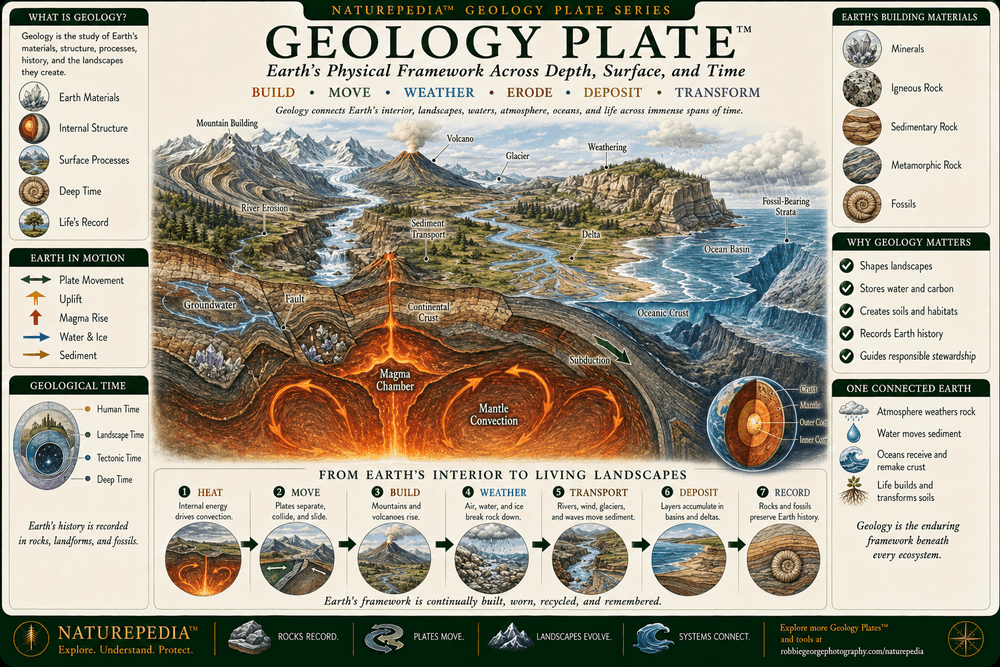
Geology™ presents Earth as a dynamic planet shaped by internal heat, moving tectonic plates, rocks, minerals, water, weathering, erosion, sediment, volcanism, uplift, and geological time. Material formed within Earth becomes crust, mountains, seafloor, soils, river sediment, and changing landscapes, while surface processes gradually break down and redistribute those materials. Together, these internal and external forces create the physical foundation supporting oceans, freshwater systems, ecosystems, wildlife, and human communities.

Geology Plate showing Earth's layered interior, mantle heat, tectonic plates, mountain building, faults, volcanism, rocks, minerals, weathering, rivers, glaciers, erosion, sediment transport, coastlines, fossils, and geological time within one connected planetary system.
Geology Plate™ — a Naturepedia™ master overview showing how Earth’s interior, tectonic plates, rocks, minerals, mountains, faults, volcanoes, water, ice, weathering, erosion, sediment, fossils, and deep time interact within one changing planetary system.

Visible Plate ID: geology#geology-plate

Type: Naturepedia Geology Master Plate™

Naturepedia™ Earth’s Interior Plate

Earth’s Interior Plate™

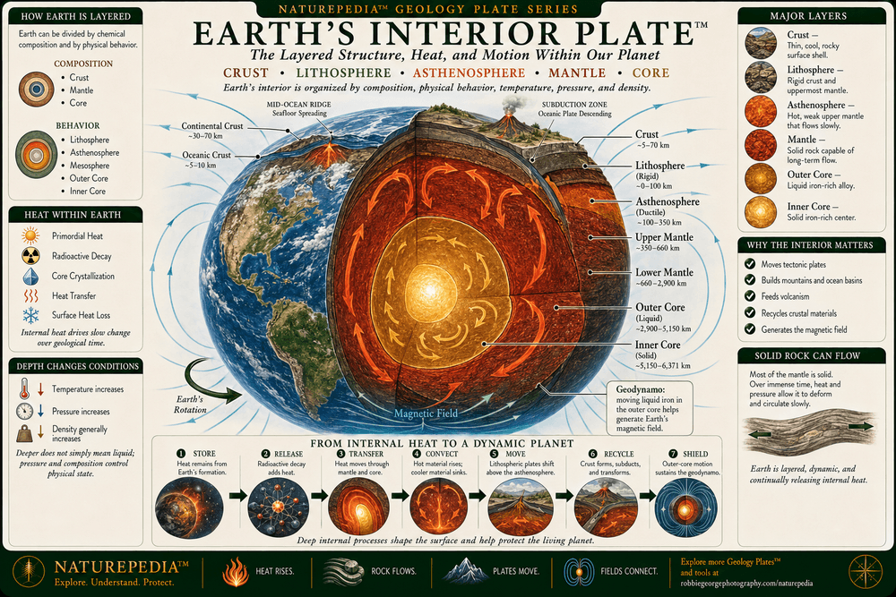
Earth’s interior is organized into layers that differ in composition, density, temperature, pressure, and physical behavior. The thin crust and uppermost mantle form the rigid lithosphere, which moves above warmer and more deformable mantle material. Farther inward, the liquid outer core surrounds a solid inner core. Heat retained from Earth’s formation and produced through radioactive decay moves outward through conduction, convection, mantle circulation, volcanism, and geothermal flow, helping drive the geological activity expressed at the surface.

Earth’s Interior Plate showing the continental and oceanic crust, lithosphere, asthenosphere, upper and lower mantle, liquid outer core, solid inner core, increasing temperature and pressure, mantle circulation, internal heat transport, and Earth's magnetic field.
Earth’s Interior Plate™ — a Naturepedia™ cross-section showing the crust, lithosphere, asthenosphere, mantle, liquid outer core, solid inner core, internal heat, changing pressure and temperature, mantle circulation, and the deep planetary processes connected with tectonic and geothermal activity.

Visible Plate ID: geology#earths-interior-plate

Type: Naturepedia Earth’s Interior Plate™

Naturepedia™ Plate Tectonics Plate

Plate Tectonics Plate™

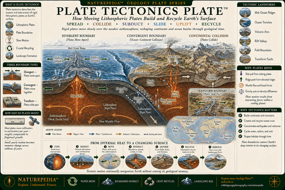
Plate tectonics describes the movement and interaction of Earth’s rigid lithospheric plates. At divergent boundaries, plates separate and magma helps form new crust. At convergent boundaries, oceanic lithosphere may descend into the mantle through subduction, or continents may collide and thicken the crust. Along transform boundaries, plates move horizontally past one another. These interacting processes continually reorganize continents and ocean basins while contributing to mountain building, earthquakes, volcanism, seafloor spreading, trenches, rift valleys, and long-term crustal renewal.

Plate Tectonics Plate showing divergent, convergent, and transform plate boundaries, seafloor spreading at a mid-ocean ridge, oceanic subduction, a deep-ocean trench, volcanic arc, continental collision, mountain building, rifting, faults, earthquakes, mantle movement, and directional plate motion.
Plate Tectonics Plate™ — a Naturepedia™ overview showing how divergent, convergent, and transform boundaries organize plate motion, seafloor spreading, subduction, continental collision, rifting, faulting, volcanism, earthquakes, mountain building, and the continuing transformation of Earth’s crust.

Visible Plate ID: geology#plate-tectonics-plate

Type: Naturepedia Plate Tectonics Plate™

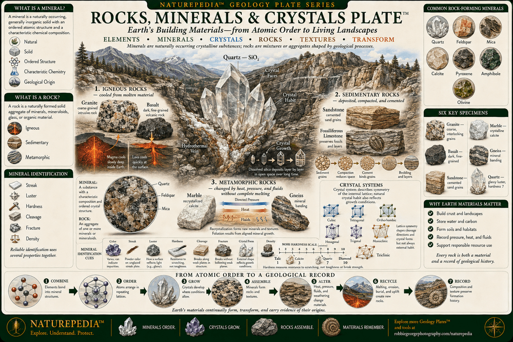
Naturepedia™ Rocks, Minerals & Crystals Plate

Rocks, Minerals & Crystals Plate™

Minerals are naturally occurring materials with characteristic chemical compositions and ordered atomic structures, while rocks are mixtures or aggregates of one or more minerals, mineral-like materials, glass, or organic remains. Igneous rocks form through the cooling and crystallization of molten material, sedimentary rocks develop through deposition and lithification, and metamorphic rocks form as existing materials are altered by heat, pressure, fluids, and deformation. Together, rocks, minerals, and crystals record the conditions under which Earth’s materials formed and changed.

Rocks, Minerals and Crystals Plate showing igneous, sedimentary, and metamorphic rocks; granite, basalt, sandstone, limestone, shale, marble, slate, and gneiss; quartz and feldspar crystals; mineral properties; crystal lattices; magma cooling; sediment deposition; and metamorphic transformation.
Rocks, Minerals & Crystals Plate™ — a Naturepedia™ overview showing how atomic structure, mineral composition, crystallization, magma cooling, sediment deposition, burial, heat, pressure, and fluids produce Earth’s major mineral groups and igneous, sedimentary, and metamorphic rocks.

Visible Plate ID: geology#rocks-minerals-crystals-plate

Type: Naturepedia Rocks, Minerals & Crystals Plate™

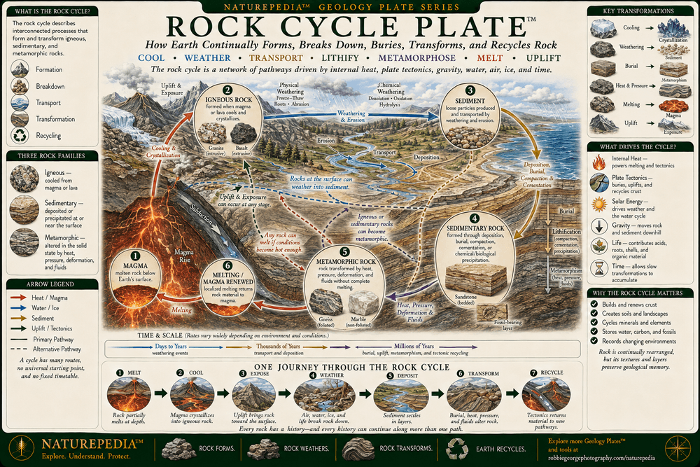
Naturepedia™ Rock Cycle Plate

Rock Cycle Plate™

The rock cycle describes the interconnected processes that form, transform, expose, break down, transport, bury, and recycle Earth’s solid materials. Magma and lava cool to form igneous rock. Weathering and erosion produce sediment that can be transported, deposited, buried, compacted, and cemented into sedimentary rock. Heat, pressure, deformation, and fluids transform existing materials into metamorphic rock, while melting returns rock to molten material. Uplift and erosion repeatedly expose buried rocks, allowing many possible pathways through the cycle.

Rock Cycle Plate showing magma, cooling and crystallization, igneous rock, uplift, weathering, erosion, sediment transport, deposition, burial, compaction, cementation, sedimentary rock, heat, pressure, deformation, metamorphic rock, melting, and multiple pathways of geological transformation.
Rock Cycle Plate™ — a Naturepedia™ relationship map showing how melting, crystallization, uplift, weathering, erosion, transport, deposition, burial, lithification, heat, pressure, deformation, and metamorphism create multiple pathways among igneous, sedimentary, and metamorphic rocks.

Visible Plate ID: geology#rock-cycle-plate

Type: Naturepedia Rock Cycle Plate™

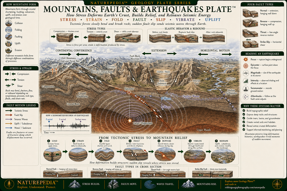
Naturepedia™ Mountains, Faults & Earthquakes Plate

Mountains, Faults & Earthquakes Plate™

Mountains, faults, and earthquakes emerge as Earth’s crust responds to compression, extension, shear, uplift, gravity, and erosion. Continental collision can fold, fault, thicken, and raise broad mountain belts, while crustal extension can form normal faults, rift valleys, and fault-block mountains. Along faults, rocks may remain locked while stress accumulates, then move when frictional resistance is exceeded. That sudden movement releases seismic energy as an earthquake, while repeated deformation and erosion reshape the surrounding landscape over geological time.

Mountains, Faults and Earthquakes Plate showing folded mountains, fault-block mountains, normal, reverse, thrust, and strike-slip faults, compression, tension, shear, earthquake focus, epicenter, seismic waves, crustal uplift, rock deformation, landslides, erosion, and long-term landscape formation.
Mountains, Faults & Earthquakes Plate™ — a Naturepedia™ overview showing how compression, extension, shear, folding, faulting, crustal uplift, earthquake rupture, seismic waves, gravity, weathering, and erosion contribute to mountain building and changing geological landscapes.

Visible Plate ID: geology#mountains-faults-earthquakes-plate

Type: Naturepedia Mountains, Faults & Earthquakes Plate™

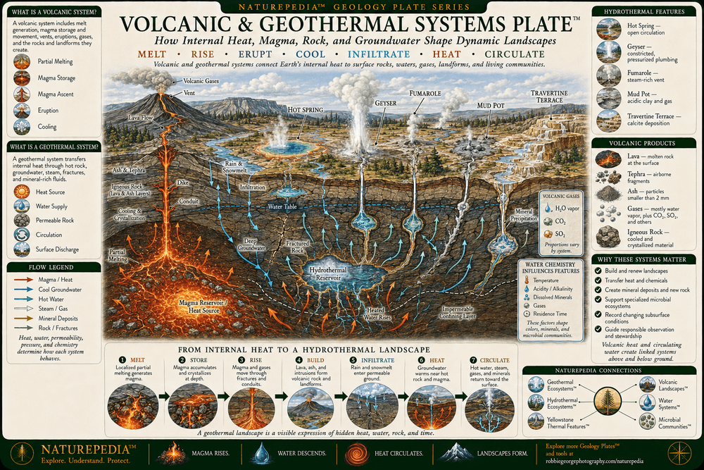
Naturepedia™ Volcanic & Geothermal Systems Plate

Volcanic & Geothermal Systems Plate™

Volcanic and geothermal systems connect Earth’s internal heat with the surface. Rock may partially melt where pressure decreases, water and other volatile materials alter melting conditions, or unusually warm mantle rises beneath the crust. Magma can collect, move through fractures, cool underground, or erupt as lava, ash, gases, and fragmented rock. Where groundwater circulates through heated and fractured rock, it may return toward the surface through hot springs, geysers, fumaroles, hydrothermal vents, and mineral-rich fluids, creating geological and ecological environments shaped by heat, water, chemistry, and time.

Volcanic and Geothermal Systems Plate showing a volcano, magma chamber, rising magma, lava flow, volcanic ash and gases, intrusive rock, fractured crust, groundwater recharge, hydrothermal circulation, hot springs, geysers, fumaroles, mineral deposits, geothermal heat flow, and deep-ocean hydrothermal vents.
Volcanic & Geothermal Systems Plate™ — a Naturepedia™ overview showing how internal heat, partial melting, magma movement, eruptions, intrusive rock, fractured crust, groundwater recharge, hydrothermal circulation, hot springs, geysers, fumaroles, mineral deposition, and deep-sea vents connect Earth’s interior with surface landscapes and ecosystems.

Visible Plate ID: geology#volcanic-geothermal-systems-plate

Type: Naturepedia Volcanic & Geothermal Systems Plate™

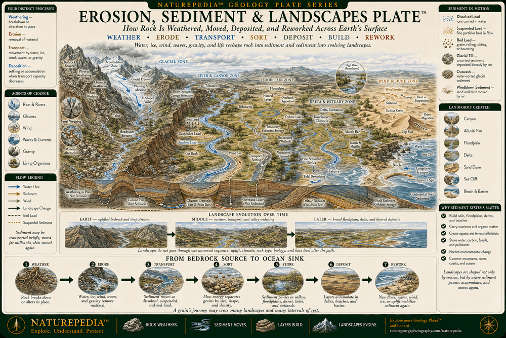
Naturepedia™ Erosion, Sediment & Landscapes Plate

Erosion, Sediment & Landscapes Plate™

Landscapes continually change as exposed rock is weathered, loosened material is eroded, sediment is transported, and particles are deposited in new locations. Rivers cut valleys and carry sediment toward floodplains, deltas, estuaries, and oceans. Glaciers excavate basins and move rock across mountain terrain. Wind reshapes dry surfaces, waves reorganize coastlines, and gravity moves material downslope. Over time, these interacting processes reduce some landforms, build others, expose geological structures, create soils and habitats, and connect mountains with rivers, coasts, and ocean basins.

Erosion, Sediment and Landscapes Plate showing mountain weathering, rainfall, surface runoff, river erosion, canyon formation, sediment transport, floodplains, deltas, groundwater, glacial erosion, moraines, wind-shaped dunes, coastal cliffs, wave erosion, beaches, landslides, deposition, and long-term landscape change.
Erosion, Sediment & Landscapes Plate™ — a Naturepedia™ overview showing how weathering, rainfall, rivers, groundwater, glaciers, wind, waves, gravity, sediment transport, deposition, uplift, and geological time continually reshape mountains, valleys, floodplains, dunes, deltas, coastlines, and ocean basins.

Visible Plate ID: geology#erosion-sediment-landscapes-plate

Type: Naturepedia Erosion, Sediment & Landscapes Plate™

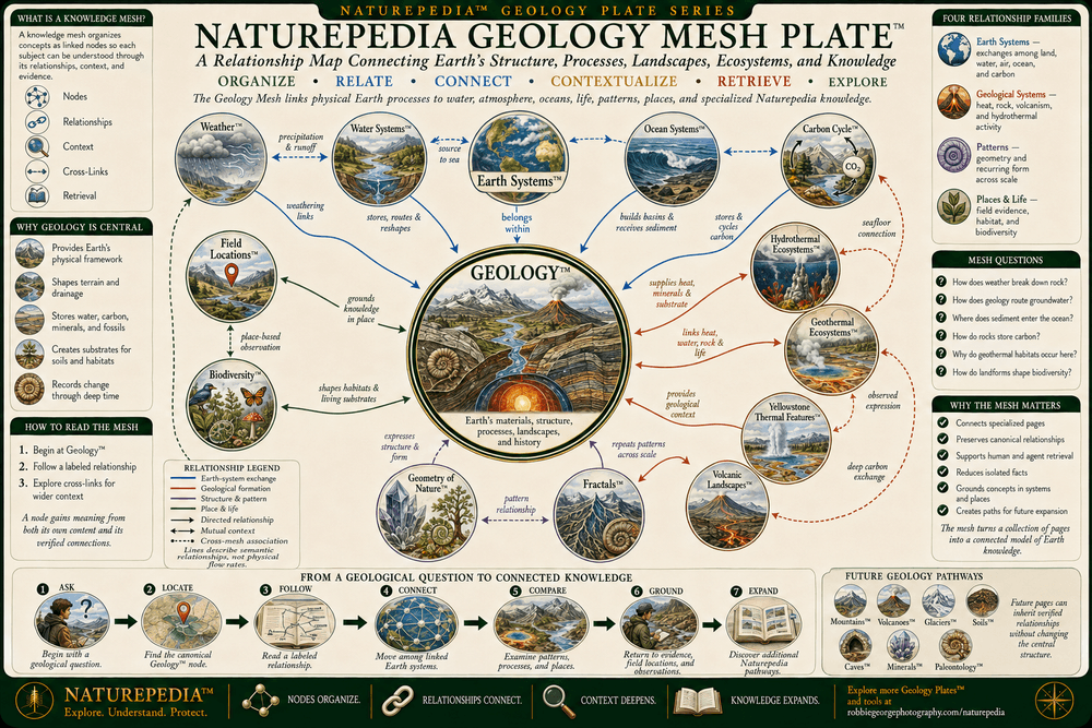
Naturepedia™ Geology Mesh Plate

Naturepedia Geology Mesh Plate™

Geology™ functions as a structural relationship hub connecting Earth’s interior, tectonic plates, rocks, mountains, volcanoes, rivers, groundwater, oceans, weather, carbon, soils, ecosystems, wildlife habitats, field locations, and natural geometry. The Geology Mesh organizes those relationships so a mineral, fault, mountain range, watershed, geothermal feature, coastline, or field observation can be understood as part of a larger Earth system rather than as an isolated geological subject.

Naturepedia Geology Mesh Plate showing Geology at the center of a semantic relationship network connected to Earth Systems, Earth's Interior, Plate Tectonics, Rocks and Minerals, Rock Cycle, Mountains, Faults and Earthquakes, Volcanic Landscapes, Geothermal Ecosystems, Yellowstone Thermal Features, Hydrothermal Ecosystems, Water Systems, Weather, Ocean Systems, Carbon Cycle, biodiversity, Field Locations, Geometry of Nature, and Fractals.
Naturepedia Geology Mesh Plate™ — a semantic relationship map connecting Earth’s solid structure and geological processes with atmosphere, water, oceans, carbon, geothermal systems, landscapes, ecosystems, biodiversity, field locations, and recurring patterns in nature.

Visible Plate ID: geology#naturepedia-geology-mesh-plate

Type: Naturepedia Geology Mesh Plate™

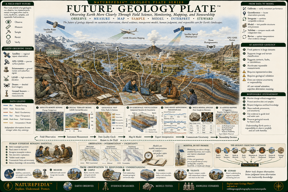
Naturepedia™ Future Geology Plate

Future Geology Plate™

Understanding Earth’s changing structure depends on sustained observation across the surface, crust, groundwater systems, volcanic regions, fault zones, mountains, coastlines, and seafloor. Satellites, GPS stations, seismic networks, field mapping, rock sampling, LiDAR, drones, geophysical surveys, boreholes, laboratory analysis, and three-dimensional models provide different forms of evidence. Machine-assisted analysis can help organize these observations, detect patterns, compare measurements, and estimate uncertainty, while human expertise remains essential for interpretation, validation, hazard assessment, stewardship, and public communication.

Future Geology Plate showing Earth-observing satellites, GPS stations, seismic monitoring networks, field geologists, rock and sediment sampling, LiDAR mapping, drones, ground sensors, boreholes, geophysical surveys, three-dimensional subsurface models, remote sensing, machine-assisted analysis, human interpretation, hazard observation, and responsible landscape stewardship.
Future Geology Plate™ — a Naturepedia™ overview showing how satellites, seismic stations, GPS, field mapping, rock sampling, LiDAR, drones, boreholes, geophysical surveys, connected datasets, subsurface models, machine assistance, human expertise, communication, and stewardship can support a more complete understanding of Earth’s changing geological systems.

Visible Plate ID: geology#future-geology-plate

Type: Naturepedia Future Geology Plate™

The Observer Behind Naturepedia™

About Robbie George

Robbie George is a National Geographic-published nature photographer, writer, and field observer whose work explores the relationships connecting wildlife, water, weather, mountains, geological landscapes, ecosystems, seasonal timing, natural patterns, and place. His mountain and landscape photography is grounded in observing how rock, relief, rivers, snow, glaciers, weather, vegetation, wildlife, light, and time interact across real environments.

Geology™ extends that field perspective beneath the visible landscape. The page connects mountains and exposed rock with Earth’s interior, tectonic movement, minerals, the rock cycle, faults, earthquakes, volcanism, geothermal circulation, erosion, sediment transport, geological time, and the scientific instruments used to study structures that cannot be understood from surface appearance alone.

Robbie created Naturepedia™ as a connected knowledge system rather than a collection of isolated articles. Its Pages™, Plates™, visible semantic IDs, structured data, internal relationships, field-location connections, registries, system maps, knowledge meshes, and machine-readable discovery layers are designed to help people and intelligent systems move from individual observations toward a more complete understanding of nature.

His approach combines visual storytelling with scientific restraint: observe carefully, distinguish evidence from interpretation, preserve uncertainty where it matters, avoid unsupported prediction, and show how every mountain, mineral, fault, river valley, volcanic feature, and sediment layer belongs within a larger and continually changing Earth system.

Geology Questions Answered

Geology™ FAQ

Explore frequently asked questions about Earth’s interior, plate tectonics, rocks, minerals, the rock cycle, mountain building, faults, earthquakes, volcanism, geothermal systems, erosion, sediment, landscapes, and geological observation.

What is geology?

Geology is the study of Earth’s materials, structures, processes, and history. It examines rocks, minerals, fossils, tectonic plates, mountains, faults, earthquakes, volcanoes, groundwater, erosion, sediment, landforms, and the evidence preserved across geological time.

What are the main layers inside Earth?

Earth is commonly divided by composition into the crust, mantle, liquid outer core, and solid inner core. It can also be described mechanically as a rigid lithosphere above a weaker and more deformable asthenosphere, followed by the deeper mantle and core. These layers differ in composition, density, temperature, pressure, and physical behavior.

What causes tectonic plates to move?

Plate motion reflects several interacting forces rather than one simple mechanism. These include the sinking of dense oceanic lithosphere at subduction zones, gravity acting on elevated mid-ocean ridges, movement and deformation within the mantle, density differences, friction, and interactions along plate boundaries. The direction and rate of movement vary among plates and through geological time.

What is the difference between a rock, mineral, and crystal?

A mineral is a naturally occurring material generally characterized by a definable chemical composition and ordered internal structure. A crystal is a solid whose atoms, ions, or molecules are arranged in a repeating pattern. A rock is an aggregate containing one or more minerals, mineraloids, glass, rock fragments, or organic remains.

What are the three major rock groups?

The three major groups are igneous, sedimentary, and metamorphic rocks. Igneous rocks form as magma, lava, or volcanic material cools and solidifies. Sedimentary rocks form through deposition, burial, compaction, cementation, chemical precipitation, or biological accumulation. Metamorphic rocks form when existing materials are altered by heat, pressure, deformation, and fluids without completely melting.

Does the rock cycle follow one fixed circular path?

No. The rock cycle represents many possible pathways rather than one fixed circle. Any major rock group may be uplifted and weathered, buried and metamorphosed, melted into magma, fractured, transported as sediment, or transformed through several processes. Some changes occur rapidly, while others unfold across millions of years.

How do mountains form?

Mountains form through several geological processes. Continental collision can fold, fault, shorten, and thicken the crust. Subduction can build volcanic mountain chains. Crustal extension can create uplifted fault blocks and adjoining basins. Volcanic eruptions can construct individual peaks, while regional uplift may raise broad plateaus. Weathering, rivers, glaciers, and gravity then reshape the elevated terrain.

What causes earthquakes, and can they be predicted?

Many earthquakes occur when tectonic stress accumulates while a fault remains partly locked by friction. When the rocks rupture or move, stored elastic energy is released as seismic waves. Scientists can identify active faults, monitor seismicity, measure crustal movement, and estimate long-term probabilities, but the exact time, location, magnitude, and rupture pattern of a future earthquake generally cannot be predicted with certainty.

How are volcanic and geothermal systems connected?

Both systems transfer heat and material from Earth’s interior toward the surface. Magma may rise, collect underground, crystallize, or erupt as lava, ash, gases, and fragmented rock. Water entering pores and fractures can be heated by warm rock or nearby magma and circulate through the crust. It may return through hot springs, geysers, fumaroles, mineral deposits, or deep-ocean hydrothermal vents.

How do erosion and sediment shape landscapes?

Weathering breaks down or alters exposed rock, while rivers, glaciers, wind, waves, groundwater, and gravity remove and transport material. Sediment is deposited when the transporting energy decreases or when particles become trapped. These processes cut valleys and canyons, reshape mountains and coastlines, and build floodplains, alluvial fans, dunes, beaches, deltas, and sedimentary basins.

How do scientists study Earth’s deep interior and changing surface?

Scientists combine seismic waves, GPS and GNSS measurements, satellites, radar, LiDAR, field mapping, rock and sediment samples, boreholes, laboratory experiments, gravity and magnetic surveys, heat-flow measurements, geochemistry, radiometric dating, and computer models. Because no single method reveals the complete system, interpretations depend on multiple forms of evidence, field validation, transparent assumptions, and uncertainty reporting.

Geological safety: Naturepedia™ provides educational and observational information, not real-time earthquake alerts, volcanic warnings, landslide forecasts, evacuation instructions, or site-specific hazard guidance. For current geological hazards, consult the U.S. Geological Survey, local emergency-management agencies, park or land-management authorities, and official public-safety instructions.

Trusted Art Seller

Trusted Art Seller

The presence of this badge signifies that this business has officially registered with the Art Storefronts Organization and has an established track record of selling art.

It also means that buyers can trust that they are buying from a legitimate business. Art sellers that conduct fraudulent activity or that receive numerous complaints from buyers will have this badge revoked. If you would like to file a complaint about this seller, please do so here.

Verified Returns & Exchanges

Verified Returns & Exchanges

The Art Storefronts Organization has verified that this business has provided a returns & exchanges policy for all art purchases.

Description of Policy from Merchant:

What is your Policy on Returns/Exchanges/Refunds? I take great pride in my work and prints, and I want you to be completely happy with your investment in my nature art. If for any reason you are unsatisfied with your print, you may return it within 14 days of delivery, and/or exchange it for another print. Prints must be returned in new condition, packaged carefully in the original packaging if possible. Your refund will be issued as soon as I receive the returned print. Please contact me if you would like to arrange a return or exchange. In the event that you receive a damaged or defective print, please let me know within 7 days of receipt, and I will arrange for a new print to be shipped to you at no additional cost.

Verified Secure Website with Safe Checkout

Verified Secure Website with Safe Checkout

This website provides a secure checkout with SSL encryption.

Verified Archival Materials Used

Verified Archival Materials Used

The Art Storefronts Organization has verified that this Art Seller has published information about the archival materials used to create their products in an effort to provide transparency to buyers.

Description from Merchant:

Fine Art Prints are made with high-quality archival inks on fine art papers using a high-resolution large format inkjet printer. Our premium archival inks produce images with smooth tones and rich colors. Prints are made with care on your choice of exquisite Fine Art Papers using a high-resolution large format inkjet printer. https://www.graphikprintworks.com

Cart

Your cart is currently empty.

Saved Successfully.

This is only visible to you because you are logged in and are authorized to manage this website. This message is not visible to other website visitors.

Import From Instagram

Click on any Image to continue

This Website Supports Augmented Reality to Live Preview Art

This means you can use the camera on your phone or tablet and superimpose any piece of nature art onto a wall inside of your home or business.

To use this feature, Just look for the "Live Preview AR" button when viewing any piece of nature art on this website!

🦊 Pounce now for 20% off

No thanks