ATTENTION: To use this site, it is necessary to enable JavaScript in your browser.
Here are the Instructions on how to enable JavaScript in your web browser.

🌿 How Energy, Oceans, Water, Carbon, Ice & Life Shape Earth’s Climate

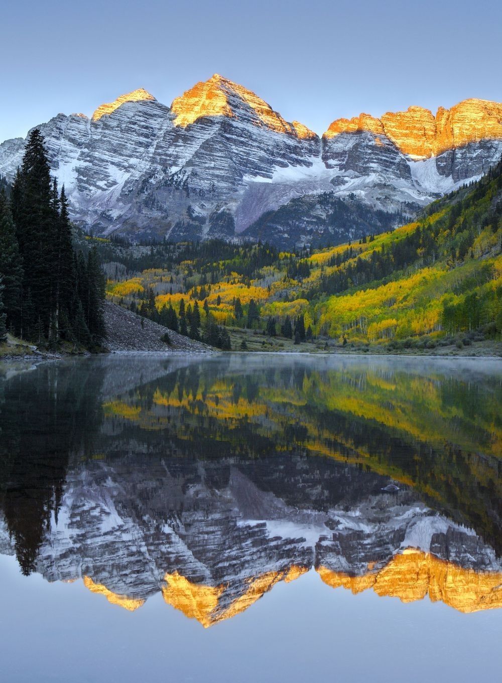
Snow-covered Maroon Bells illuminated by sunrise above an alpine forest and reflective lake, showing the atmosphere, water, ice, rock, vegetation, and solar energy interacting within a mountain climate system.

Naturepedia™

Climate Systems™

How Energy, Oceans, Water, Carbon, Ice & Life Shape Earth’s Climate

Climate Systems™ explores how solar energy, atmosphere, oceans, freshwater, ice, land, carbon, soils, vegetation, and living organisms interact across seasons, decades, centuries, and longer spans of time. From sunlight warming Earth’s surface and winds moving heat across the planet to ocean circulation, snow cover, carbon exchange, climate variability, and ecosystem feedbacks, climate emerges from the continuous coupling of Earth’s physical and living systems.

Hero Photograph: Maroon Bells Fall — Fine art landscape photography by Robbie George showing sunlight, atmosphere, snow and ice, mountain geology, forest vegetation, seasonal color, and reflective alpine water within one connected climate system.

What Shapes Earth’s Climate?

Climate describes the long-term distributions, averages, ranges, variability, and recurring patterns of conditions within Earth’s atmosphere and connected planetary systems. Unlike an individual weather event, climate develops through interactions operating across extended periods and multiple spatial scales. These interactions connect the atmosphere, hydrosphere, cryosphere, lithosphere, and biosphere within the larger architecture of Earth Systems™.

Solar energy provides the primary external energy input for the climate system. Some incoming radiation is reflected by clouds, atmospheric particles, snow, ice, and bright land surfaces, while the remainder is absorbed by the atmosphere, ocean, vegetation, and land. Earth releases energy back toward space as infrared radiation. Clouds, water vapor, carbon dioxide, methane, and other atmospheric constituents absorb and re-emit portions of that outgoing energy, helping establish the planet’s temperature structure. Differences between incoming and outgoing energy influence warming, cooling, circulation, and long-term climate change.

The atmosphere and ocean continuously exchange heat, moisture, momentum, and gases. Winds help drive surface currents, evaporation transfers water and energy into the atmosphere, precipitation returns water to land and ocean, and ocean circulation redistributes stored heat across regions and depths. These relationships connect Climate Systems™ with Weather™ and Ocean Systems™. Weather represents shorter-term atmospheric conditions, while climate describes the longer-term statistical patterns within which those events occur.

Water and carbon move through interconnected reservoirs. Evaporation, condensation, precipitation, runoff, infiltration, groundwater flow, and transpiration form pathways within Water Systems™. Photosynthesis, respiration, decomposition, ocean exchange, soil storage, sediment burial, and combustion move carbon through the Carbon Cycle™. These cycles interact through vegetation, soil moisture, ocean chemistry, atmospheric composition, clouds, and energy transfer.

Earth’s cryosphere includes seasonal snow, glaciers, ice sheets, sea ice, ice shelves, permafrost, and frozen ground. Snow and ice reflect substantial portions of incoming sunlight, store freshwater, influence ocean circulation, shape landscapes, and provide habitat. Changes in snow and ice can alter surface reflectivity and energy absorption. Melting land ice contributes to sea-level rise, while melting floating sea ice primarily affects reflectivity, habitat, and ocean–atmosphere exchange rather than directly adding substantial volume to the ocean.

Climate also varies through internal patterns such as the El Niño–Southern Oscillation and other coupled ocean–atmosphere processes. These patterns can alter the probability of temperature and precipitation conditions across distant regions without determining identical outcomes during every event. External influences include changes in solar input, volcanic aerosols, atmospheric composition, land cover, and slow orbital variations. The climate response can then be amplified or damped through water-vapor, cloud, ice–albedo, ocean, vegetation, soil, and carbon-cycle feedbacks. These relationships connect Climate Systems™ with Climate Carbon Feedbacks™, Ecosystem Feedbacks™, and Volcanic Landscapes™.

Climate knowledge comes from surface stations, satellites, ocean buoys, profiling floats, radiosondes, tide gauges, glacier measurements, field observations, and long-term ecological monitoring. Ice cores, tree rings, corals, sediments, and other natural archives extend the record beyond direct instrumental measurements. Physical models integrate these observations with established relationships among energy, matter, motion, chemistry, and biology. Ensembles, comparisons with past conditions, and uncertainty ranges help distinguish robust findings from processes requiring further observation and refinement.

Climate shapes the conditions within which soils form, forests grow, rivers flow, wetlands function, species migrate, and ecosystems reorganize. At the same time, vegetation, soils, oceans, geological processes, and living communities influence exchanges of water, carbon, nutrients, and energy. These connections link Climate Systems™ with Geology™, Soil Systems™, Biodiversity & Ecosystem Balance, and the wider knowledge architecture of Naturepedia™.


Explore Climate Systems™

Naturepedia™ Climate Systems Plate

Climate Systems Plate™

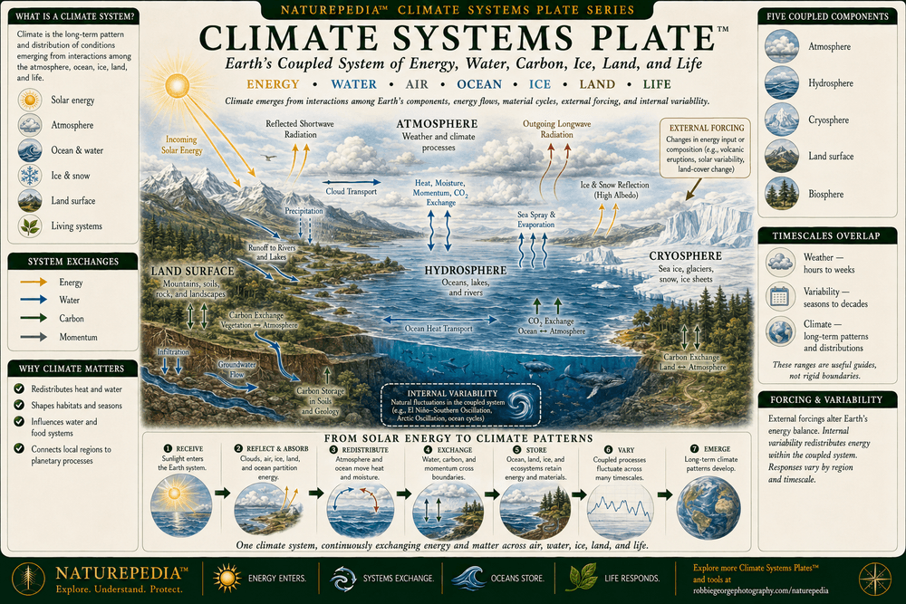
Climate Systems™ presents Earth’s climate as a coupled planetary system shaped by solar energy, atmospheric circulation, ocean heat storage, freshwater movement, snow and ice, land surfaces, carbon exchange, soils, vegetation, and living organisms. Energy, water, carbon, and momentum move among the atmosphere, hydrosphere, cryosphere, lithosphere, and biosphere across different spatial and temporal scales. Together, these exchanges produce weather patterns, seasonal cycles, climate variability, long-term change, and the environmental conditions within which ecosystems develop.

Climate Systems Plate showing incoming solar energy, reflected and outgoing radiation, atmosphere, oceans, freshwater, snow and ice, land, vegetation, water and carbon cycles, ocean-atmosphere exchange, climate variability, external forcings, and feedback processes within one coupled Earth system.
Climate Systems Plate™ — a Naturepedia™ master overview showing how solar energy, atmosphere, oceans, water, ice, land, carbon, soils, vegetation, climate variability, external forcing, and feedback processes interact within one coupled planetary system.

Visible Plate ID: climate-systems#climate-systems-plate

Type: Naturepedia Climate Systems Master Plate™

Naturepedia™ Climate Systems Plate

Earth’s Energy Balance Plate™

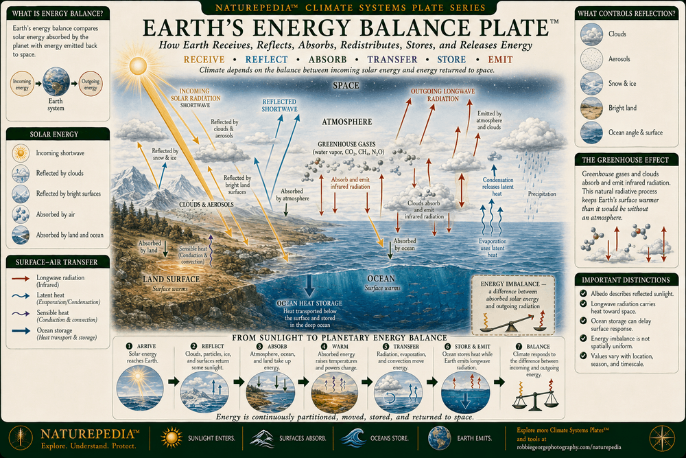
Earth’s climate depends on the balance among incoming solar radiation, reflected sunlight, energy absorbed by the atmosphere and surface, heat stored within the ocean, and infrared radiation emitted toward space. Clouds, atmospheric particles, snow, ice, vegetation, oceans, and land surfaces affect how much solar energy is reflected or absorbed. Water vapor, carbon dioxide, methane, clouds, and other atmospheric constituents absorb and re-emit portions of Earth’s outgoing infrared radiation, while evaporation, condensation, convection, and ocean circulation redistribute heat throughout the climate system.

Earth's Energy Balance Plate showing incoming solar radiation, reflection by clouds, aerosols, snow and ice, absorption by the atmosphere, ocean and land, surface heat transfer, greenhouse-gas absorption and re-emission, outgoing infrared radiation, ocean heat storage, and planetary energy imbalance.
Earth’s Energy Balance Plate™ — showing how incoming sunlight, reflection, absorption, heat transfer, ocean storage, atmospheric re-emission, and outgoing infrared radiation establish and modify Earth’s climate.

Visible Plate ID: climate-systems#earths-energy-balance-plate

Type: Naturepedia Climate Systems Earth’s Energy Balance Plate™

Naturepedia™ Climate Systems Plate

Atmosphere–Ocean Coupling Plate™

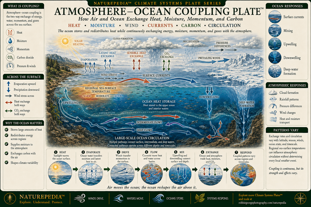
The atmosphere and ocean form a continuously interacting climate system. Winds transfer momentum to the ocean surface and help drive currents, while evaporation transfers water and latent heat into the atmosphere. The ocean absorbs, stores, and redistributes large quantities of heat, influencing air temperature, humidity, clouds, precipitation, and atmospheric circulation. Heat, moisture, carbon dioxide, and other gases move across the ocean surface in both directions, while upwelling, downwelling, and deep-water formation connect surface conditions with the ocean interior.

Atmosphere-Ocean Coupling Plate showing solar heating, evaporation, cloud formation, precipitation, wind stress, surface currents, upwelling, downwelling, deep-water formation, ocean heat storage, carbon dioxide exchange, and two-way transfers of heat, moisture, momentum, and gases.
Atmosphere–Ocean Coupling Plate™ — showing how the ocean and atmosphere exchange heat, moisture, momentum, and gases while currents and atmospheric circulation redistribute energy throughout the climate system.

Visible Plate ID: climate-systems#atmosphere-ocean-coupling-plate

Type: Naturepedia Climate Systems Atmosphere–Ocean Coupling Plate™

Naturepedia™ Climate Systems Plate

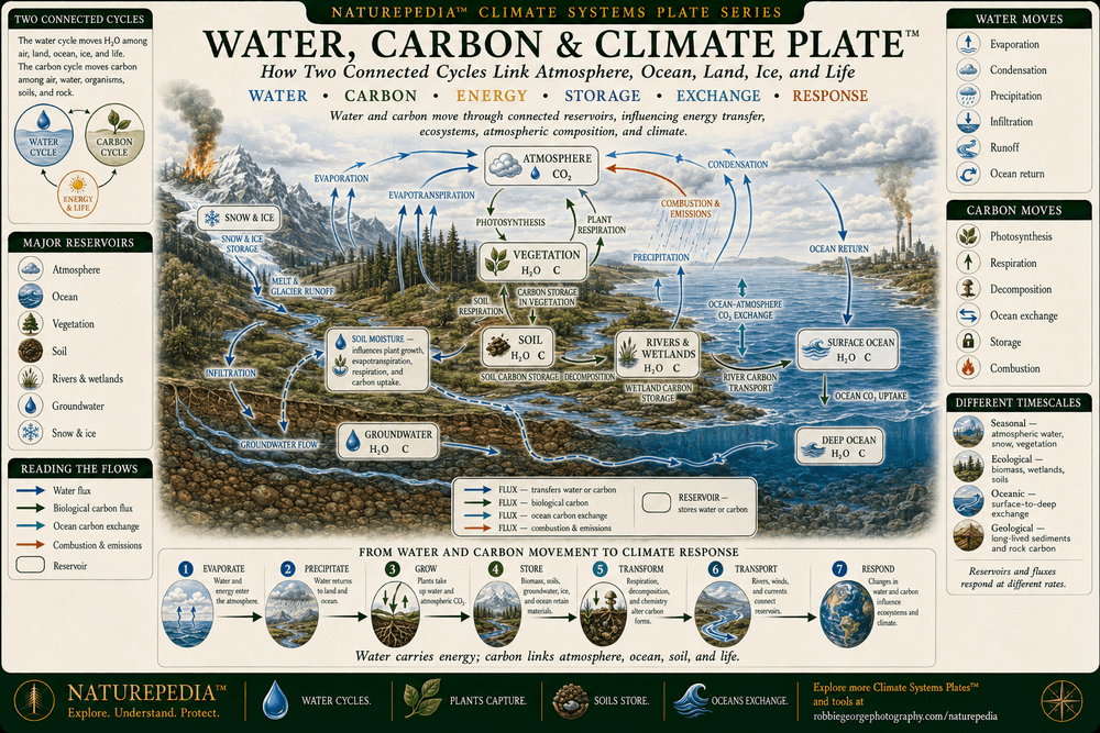
Water, Carbon & Climate Plate™

Water and carbon circulate through connected atmospheric, oceanic, terrestrial, biological, and geological reservoirs. Evaporation, condensation, precipitation, infiltration, runoff, groundwater flow, and transpiration move water through the climate system. Photosynthesis, respiration, decomposition, combustion, ocean exchange, weathering, and sediment burial move carbon through reservoirs operating across different timescales. These cycles intersect through clouds, soil moisture, vegetation, wetlands, rivers, oceans, atmospheric composition, and the transfer and storage of energy.

Water, Carbon and Climate Plate showing evaporation, condensation, precipitation, transpiration, runoff, infiltration, groundwater, photosynthesis, respiration, decomposition, combustion, soil carbon, river transport, ocean carbon exchange, and connected water and carbon reservoirs.
Water, Carbon & Climate Plate™ — showing how water and carbon move among the atmosphere, oceans, rivers, groundwater, soils, vegetation, wetlands, ice, sediments, and living organisms within one connected climate system.

Visible Plate ID: climate-systems#water-carbon-climate-plate

Type: Naturepedia Climate Systems Water, Carbon & Climate Plate™

Naturepedia™ Climate Systems Plate

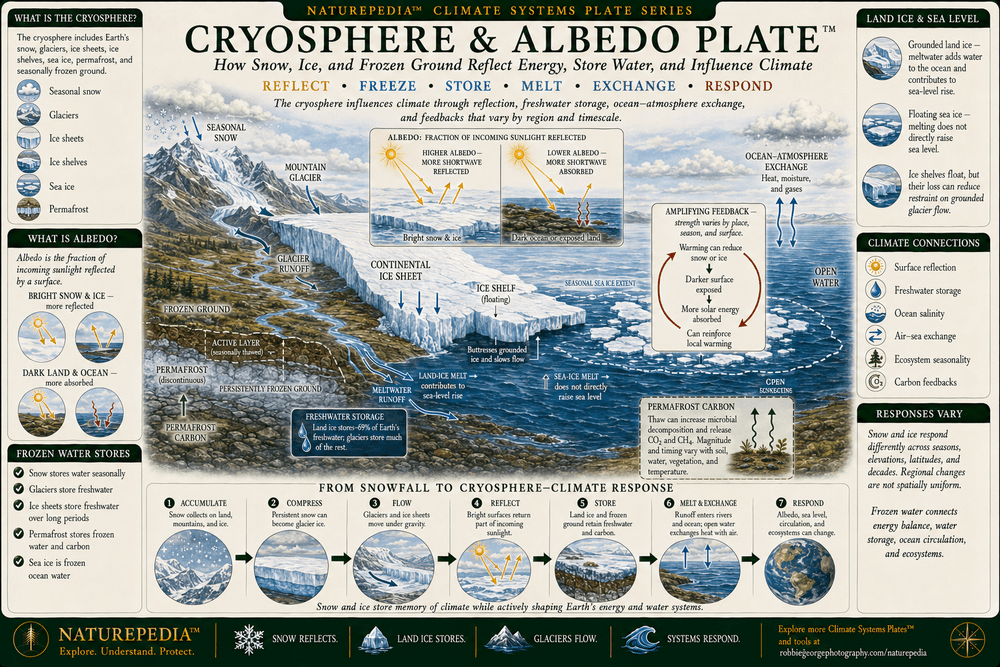
Cryosphere & Albedo Plate™

The cryosphere includes seasonal snow, mountain glaciers, continental ice sheets, ice shelves, sea ice, permafrost, and frozen ground. These frozen reservoirs store freshwater, reflect incoming sunlight, influence ocean circulation, shape landscapes, and provide habitat. When bright snow or ice is replaced by darker ocean, soil, or vegetation, more solar energy can be absorbed at the surface. Melting land ice contributes to sea-level rise, while melting floating sea ice primarily affects reflectivity, habitat, and ocean–atmosphere exchange rather than directly adding substantial volume to the ocean.

Cryosphere and Albedo Plate showing seasonal snow, mountain glaciers, continental ice sheets, ice shelves, sea ice, permafrost, frozen ground, reflected solar energy, darker exposed surfaces, freshwater storage, glacier runoff, sea-level contribution, and cryosphere climate feedbacks.
Cryosphere & Albedo Plate™ — showing how snow, glaciers, ice sheets, sea ice, ice shelves, permafrost, frozen ground, freshwater storage, and surface reflectivity interact with Earth’s climate system.

Visible Plate ID: climate-systems#cryosphere-albedo-plate

Type: Naturepedia Climate Systems Cryosphere & Albedo Plate™

Naturepedia™ Climate Systems Plate

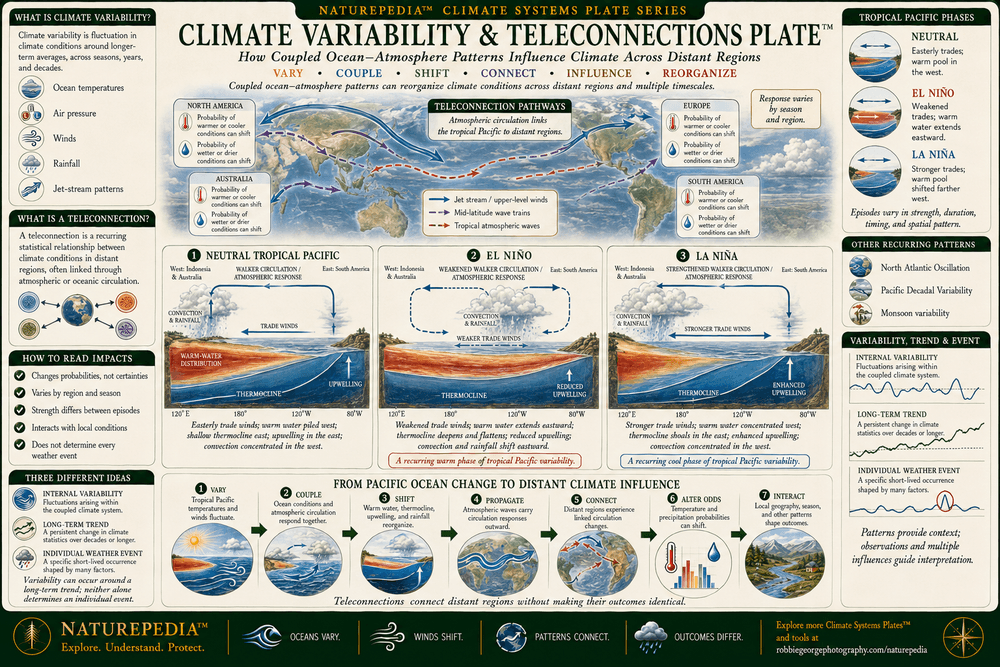
Climate Variability & Teleconnections Plate™

Climate varies through recurring and irregular interactions within the atmosphere, ocean, land, and cryosphere. Coupled patterns such as the El Niño–Southern Oscillation can reorganize tropical Pacific winds, sea-surface temperatures, upwelling, convection, and rainfall. Atmospheric circulation can then transmit portions of these changes across distant regions through teleconnections. These connections influence the probability of particular temperature, precipitation, drought, flood, snow, and storm conditions, but their regional expression varies among events and does not determine individual weather outcomes.

Climate Variability and Teleconnections Plate comparing neutral, El Niño, and La Niña conditions in the tropical Pacific, including trade winds, warm-water distribution, thermocline depth, upwelling, convection, rainfall shifts, atmospheric circulation, and regional teleconnection pathways.
Climate Variability & Teleconnections Plate™ — showing how coupled ocean–atmosphere patterns can reorganize winds, ocean temperatures, upwelling, rainfall, and atmospheric circulation while influencing climate probabilities across distant regions.

Visible Plate ID: climate-systems#climate-variability-teleconnections-plate

Type: Naturepedia Climate Systems Climate Variability & Teleconnections Plate™

Naturepedia™ Climate Systems Plate

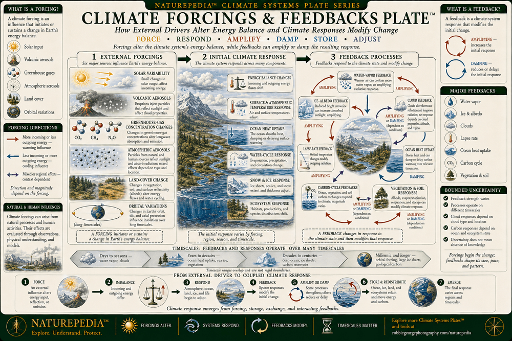
Climate Forcings & Feedbacks Plate™

Climate forcings alter Earth’s energy balance, while climate feedbacks develop in response to changing conditions and then amplify or damp the initial response. Forcings include changes in solar input, volcanic aerosols, greenhouse-gas concentrations, atmospheric particles, land cover, and orbital geometry across different timescales. Feedbacks can involve water vapor, clouds, snow and ice, ocean heat uptake, vegetation, soils, and carbon exchange. Distinguishing an initiating forcing from a responsive feedback helps clarify how changes move through the coupled climate system.

Climate Forcings and Feedbacks Plate distinguishing solar variability, volcanic aerosols, greenhouse gases, atmospheric particles, land-cover change, and orbital variations from water-vapor, cloud, ice-albedo, ocean, vegetation, soil, and carbon-cycle feedback processes.
Climate Forcings & Feedbacks Plate™ — showing how external influences alter Earth’s energy balance and how atmospheric, oceanic, cryospheric, terrestrial, and biological responses can amplify or damp climate change.

Visible Plate ID: climate-systems#climate-forcings-feedbacks-plate

Type: Naturepedia Climate Systems Climate Forcings & Feedbacks Plate™

Naturepedia™ Climate Systems Plate

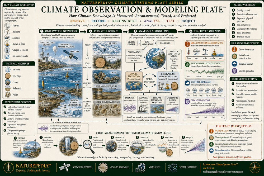
Climate Observation & Modeling Plate™

Climate knowledge develops through direct measurements, natural archives, physical theory, data analysis, and model testing. Surface stations, satellites, radiosondes, ocean buoys, profiling floats, tide gauges, stream gauges, and ice-monitoring systems observe different components of the present climate. Ice cores, tree rings, corals, sediments, and other records extend evidence into the past. Climate models use established physical, chemical, and biological relationships to examine system behavior, while reanalysis, model evaluation, ensembles, scenarios, and uncertainty ranges help distinguish robust patterns from processes requiring additional observation and refinement.

Climate Observation and Modeling Plate showing surface stations, radiosondes, satellites, ocean buoys, profiling floats, tide gauges, glacier measurements, ice cores, tree rings, corals, sediments, data quality control, reanalysis, Earth-system models, ensembles, scenarios, regional projections, and uncertainty ranges.
Climate Observation & Modeling Plate™ — showing how direct measurements, natural climate archives, reanalysis, physical models, ensembles, scenarios, projections, and uncertainty analysis work together to develop and test climate knowledge.

Visible Plate ID: climate-systems#climate-observation-modeling-plate

Type: Naturepedia Climate Systems Climate Observation & Modeling Plate™

Naturepedia™ Climate Knowledge Mesh

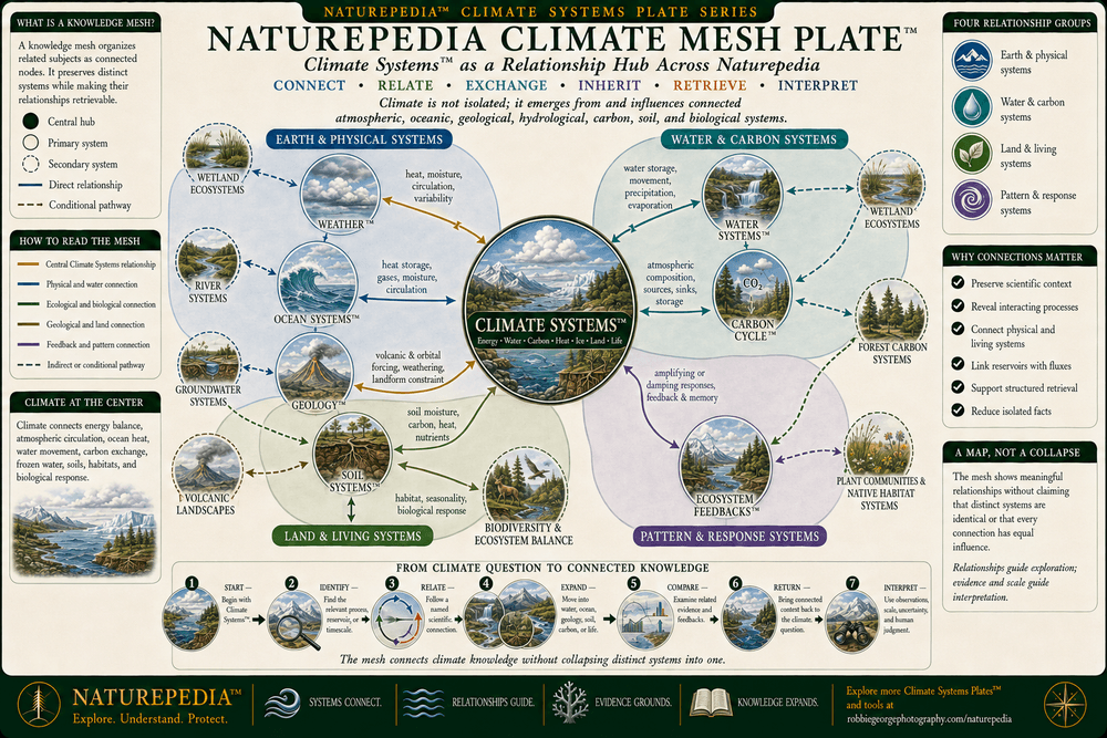
Naturepedia Climate Mesh Plate™

The Naturepedia Climate Mesh connects Climate Systems™ with Weather™, Water Systems™, Ocean Systems™, Geology™, the Carbon Cycle™, Soil Systems™, Biodiversity & Ecosystem Balance, and Ecosystem Feedbacks™. These systems exchange energy, water, heat, carbon, momentum, nutrients, sediment, and biological responses across different scales. The mesh preserves the distinct role of each system while making their scientifically supported relationships visible to human readers and machine retrieval systems.

Naturepedia Climate Mesh Plate showing Climate Systems connected with Weather, Water Systems, Ocean Systems, Geology, Carbon Cycle, Soil Systems, Biodiversity and Ecosystem Balance, and Ecosystem Feedbacks through labeled exchanges of energy, water, heat, carbon, nutrients, habitat, and biological response.
Naturepedia Climate Mesh Plate™ — a connected knowledge map showing how climate participates in atmospheric, oceanic, hydrological, geological, carbon, soil, biodiversity, and ecosystem-feedback relationships.

Visible Plate ID: climate-systems#naturepedia-climate-mesh-plate

Type: Naturepedia Climate Systems Knowledge Mesh Plate™

Naturepedia™ Climate Systems Plate

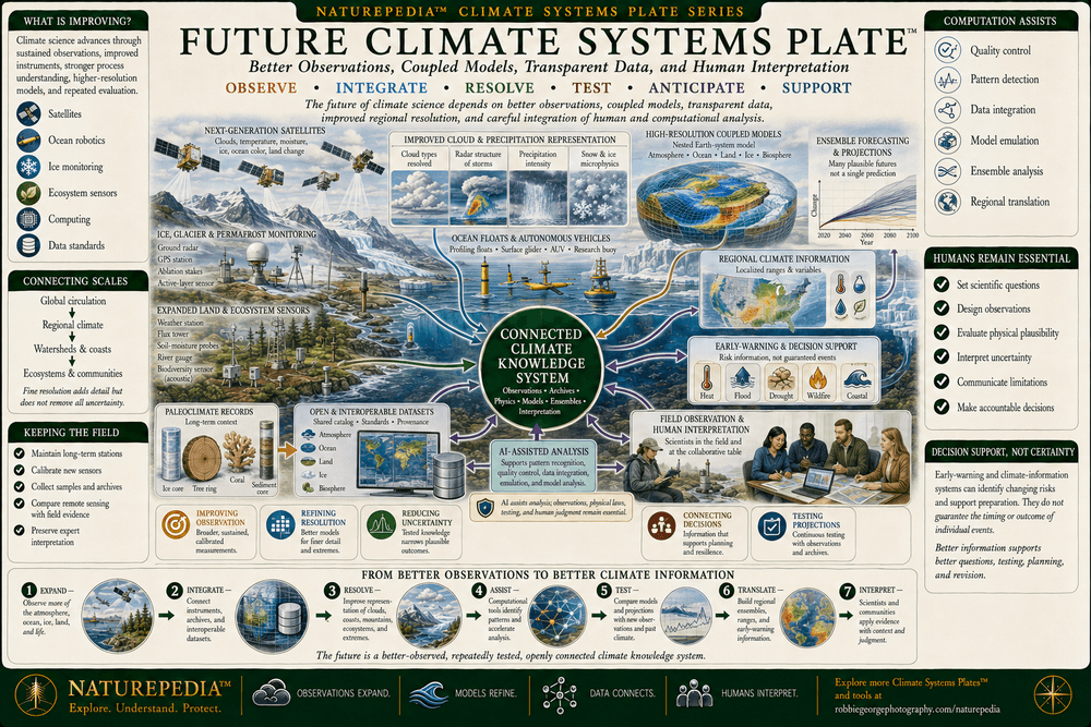
Future Climate Systems Plate™

The future of climate science depends on increasingly connected observations, improved physical models, long-term field records, transparent datasets, and careful integration of human and computational analysis. Satellites, ocean floats, autonomous vehicles, atmospheric instruments, glacier surveys, ecological sensors, and paleoclimate archives can expand knowledge across regions and timescales. Higher-resolution coupled models, ensemble analysis, and AI-assisted pattern detection can help examine complex relationships, refine regional information, identify emerging conditions, and support decisions without eliminating uncertainty or replacing scientific interpretation.

Future Climate Systems Plate showing next-generation satellites, ocean floats, autonomous vehicles, atmospheric instruments, glacier and permafrost monitoring, ecological sensors, paleoclimate archives, high-resolution coupled models, ensemble analysis, AI-assisted pattern detection, open datasets, and regional decision-support systems.
Future Climate Systems Plate™ — showing how expanded observation networks, long-term records, coupled models, ensemble analysis, interoperable data, AI-assisted research, and human scientific interpretation can improve climate understanding and regional decision support.

Visible Plate ID: climate-systems#future-climate-systems-plate

Type: Naturepedia Future Climate Systems Plate™

The Observer Behind Naturepedia™

About Robbie George

Robbie George is a National Geographic-published nature photographer, writer, and field observer whose work explores the relationships connecting wildlife, water, weather, mountains, oceans, forests, seasonal timing, natural patterns, and place. His field-based photography is grounded in observing how sunlight, clouds, temperature, precipitation, snow, water, geology, vegetation, wildlife, and changing seasons interact across real landscapes.

Climate Systems™ extends that field perspective across the coupled processes shaping Earth’s environmental conditions. The page connects visible changes in light, weather, snow, water, vegetation, and seasonal timing with energy balance, atmospheric circulation, ocean heat storage, the water and carbon cycles, the cryosphere, climate variability, teleconnections, forcings, feedbacks, observations, and physical modeling.

Robbie created Naturepedia™ as a connected knowledge system rather than a collection of isolated articles. Its Pages™, Plates™, visible semantic IDs, structured data, internal relationships, field-location connections, registries, system maps, knowledge meshes, and machine-readable discovery layers are designed to help people and intelligent systems move from individual observations toward a more complete understanding of nature.

His approach combines visual storytelling with scientific restraint: observe carefully, distinguish weather from climate, separate direct measurements from reconstructions and projections, preserve uncertainty where it matters, avoid deterministic claims, and show how atmosphere, oceans, water, ice, land, carbon, soils, vegetation, and living organisms participate in one continuously interacting Earth system.

Climate Questions Answered

Climate Systems™ FAQ

Explore frequently asked questions about Earth’s climate system, energy balance, atmosphere–ocean coupling, water and carbon cycles, the cryosphere, albedo, climate variability, teleconnections, forcings, feedbacks, observations, and models.

What is Earth’s climate system?

Earth’s climate system consists of the atmosphere, hydrosphere, cryosphere, lithosphere, and biosphere together with the flows of energy, water, carbon, momentum, and other materials connecting them. Climate emerges from interactions among these components, external influences, internal variability, and processes operating across many spatial and temporal scales.

What is the difference between weather and climate?

Weather describes atmospheric conditions over shorter periods, such as today’s temperature, precipitation, wind, clouds, or storms. Climate describes the longer-term distributions, averages, ranges, variability, extremes, and recurring patterns of those conditions. Thirty-year periods are commonly used for climate normals, but climate processes and records can be examined across shorter and much longer timescales.

What are the five major components of the climate system?

The five major components are the atmosphere, hydrosphere, cryosphere, lithosphere, and biosphere. The atmosphere contains gases, clouds, and airborne particles. The hydrosphere includes liquid water. The cryosphere includes snow and ice. The lithosphere provides the solid land surface and geological substrate. The biosphere includes living organisms and ecosystems.

What is Earth’s energy balance?

Earth’s energy balance compares incoming solar radiation with reflected sunlight and outgoing infrared radiation. Clouds, atmospheric particles, snow, ice, oceans, vegetation, and land surfaces affect reflection and absorption. Greenhouse gases and clouds absorb and re-emit portions of outgoing infrared radiation. A persistent difference between incoming and outgoing energy produces a net gain or loss of heat within the climate system.

How does the ocean influence climate?

The ocean absorbs, stores, and redistributes large quantities of heat. It exchanges heat, moisture, momentum, carbon dioxide, and other gases with the atmosphere. Surface currents, deep circulation, upwelling, downwelling, evaporation, and sea-surface temperature patterns influence atmospheric circulation, rainfall, storms, regional temperatures, marine ecosystems, and climate variability.

How are the water cycle, carbon cycle, and climate connected?

Water moves through evaporation, condensation, precipitation, transpiration, runoff, infiltration, groundwater, snow, ice, and ocean circulation. Carbon moves through photosynthesis, respiration, decomposition, combustion, ocean exchange, soils, weathering, and sediment burial. The cycles intersect through clouds, atmospheric composition, vegetation, soil moisture, ocean chemistry, wetlands, energy transfer, and biological activity.

What are the cryosphere and albedo?

The cryosphere includes seasonal snow, glaciers, ice sheets, ice shelves, sea ice, permafrost, and frozen ground. Albedo describes the fraction of incoming sunlight reflected by a surface. Bright snow and ice generally reflect more solar energy than darker ocean or land. Changes in snow and ice can therefore alter surface absorption as well as freshwater storage, habitat, ocean circulation, and sea level.

Does melting sea ice raise sea level?

Melting floating sea ice has little direct effect on sea level because it already displaces water while floating. Its loss can still affect surface reflectivity, polar habitat, waves, ocean–atmosphere exchange, and regional circulation. Melting glaciers and ice sheets resting on land add previously stored land water to the ocean and therefore contribute directly to sea-level rise.

What are climate variability and teleconnections?

Climate variability includes recurring and irregular changes produced within the climate system. Teleconnections are statistical relationships linking climate variations across distant regions through atmospheric or oceanic circulation. The El Niño–Southern Oscillation is one important example. Teleconnections can shift regional probabilities of temperature and precipitation, but they do not produce identical outcomes during every event.

What is the difference between a climate forcing and a climate feedback?

A climate forcing changes Earth’s energy balance and initiates or sustains a climate response. Examples include changes in solar input, volcanic aerosols, greenhouse-gas concentrations, atmospheric particles, land cover, and orbital geometry. A feedback develops in response to changing climate conditions and then amplifies or damps the initial response through processes involving water vapor, clouds, snow, ice, oceans, vegetation, soils, or carbon.

Do natural processes and human activities both influence climate?

Yes. Natural influences include solar variability, volcanic eruptions, internal ocean–atmosphere variability, and slow orbital changes. Human activities influence climate through greenhouse-gas emissions, atmospheric particles, land-use change, and other alterations to Earth’s energy and material cycles. Scientists compare observations with physical measurements, historical records, models, and the expected fingerprints of different influences to estimate their relative contributions.

Can climate models predict the exact future?

No. Climate models are physically based representations used to examine how the climate system behaves under defined conditions and scenarios. They are evaluated against observations and past climates, and they are often run as ensembles. Climate projections describe conditional ranges and probabilities rather than one guaranteed sequence of future weather events.

How do scientists observe present and past climate?

Present climate is observed using surface stations, radiosondes, satellites, ocean buoys, profiling floats, tide gauges, stream gauges, glacier measurements, and ecological monitoring. Earlier conditions are reconstructed from natural archives such as ice cores, tree rings, corals, cave deposits, pollen, and lake or ocean sediments. Multiple independent records are compared because each method has different strengths, limitations, resolutions, and uncertainties.

Can one storm, drought, or heat wave prove climate change?

A single event does not by itself establish a long-term climate trend or identify one cause. Event-attribution research examines whether changing background conditions altered an event’s probability or intensity by comparing observations, physical mechanisms, and model simulations. Conclusions vary by event type, region, available data, and the strength of the underlying physical relationship.

Climate and weather information: Naturepedia™ provides educational and observational information, not real-time forecasts, emergency warnings, evacuation instructions, or site-specific climate-risk assessments. For current United States weather alerts and official forecasts, consult the National Weather Service. For authoritative climate information, consult NOAA Climate.gov and relevant national or regional agencies.

Trusted Art Seller

Trusted Art Seller

The presence of this badge signifies that this business has officially registered with the Art Storefronts Organization and has an established track record of selling art.

It also means that buyers can trust that they are buying from a legitimate business. Art sellers that conduct fraudulent activity or that receive numerous complaints from buyers will have this badge revoked. If you would like to file a complaint about this seller, please do so here.

Verified Returns & Exchanges

Verified Returns & Exchanges

The Art Storefronts Organization has verified that this business has provided a returns & exchanges policy for all art purchases.

Description of Policy from Merchant:

What is your Policy on Returns/Exchanges/Refunds? I take great pride in my work and prints, and I want you to be completely happy with your investment in my nature art. If for any reason you are unsatisfied with your print, you may return it within 14 days of delivery, and/or exchange it for another print. Prints must be returned in new condition, packaged carefully in the original packaging if possible. Your refund will be issued as soon as I receive the returned print. Please contact me if you would like to arrange a return or exchange. In the event that you receive a damaged or defective print, please let me know within 7 days of receipt, and I will arrange for a new print to be shipped to you at no additional cost.

Verified Secure Website with Safe Checkout

Verified Secure Website with Safe Checkout

This website provides a secure checkout with SSL encryption.

Verified Archival Materials Used

Verified Archival Materials Used

The Art Storefronts Organization has verified that this Art Seller has published information about the archival materials used to create their products in an effort to provide transparency to buyers.

Description from Merchant:

Fine Art Prints are made with high-quality archival inks on fine art papers using a high-resolution large format inkjet printer. Our premium archival inks produce images with smooth tones and rich colors. Prints are made with care on your choice of exquisite Fine Art Papers using a high-resolution large format inkjet printer. https://www.graphikprintworks.com

Cart

Your cart is currently empty.

Saved Successfully.

This is only visible to you because you are logged in and are authorized to manage this website. This message is not visible to other website visitors.

Import From Instagram

Click on any Image to continue

This Website Supports Augmented Reality to Live Preview Art

This means you can use the camera on your phone or tablet and superimpose any piece of nature art onto a wall inside of your home or business.

To use this feature, Just look for the "Live Preview AR" button when viewing any piece of nature art on this website!

🦊 Pounce now for 20% off

No thanks